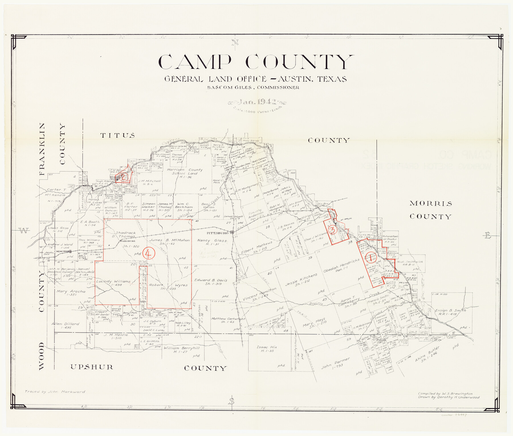
Camp County Working Sketch Graphic Index
-
Map/Doc
76487
-
Collection
General Map Collection
-
Object Dates
1/1942 (Creation Date)
-
Counties
Camp
-
Subjects
County Surveying Working Sketch
-
Height x Width
25.1 x 29.7 inches
63.8 x 75.4 cm
-
Scale
1" = 2000 varas
Part of: General Map Collection
Midland County Boundary File 4a

Print $40.00
- Digital $50.00
Midland County Boundary File 4a
Size 36.2 x 54.5 inches
Map/Doc 57185
Knox County Rolled Sketch 22

Print $20.00
- Digital $50.00
Knox County Rolled Sketch 22
1968
Size 25.4 x 37.6 inches
Map/Doc 6562
Matagorda County

Print $40.00
- Digital $50.00
Matagorda County
1920
Size 40.6 x 48.6 inches
Map/Doc 73232
Limestone County Working Sketch 10

Print $20.00
- Digital $50.00
Limestone County Working Sketch 10
1922
Size 21.1 x 10.0 inches
Map/Doc 70560
Chart showing the relative positions of the lights in the Eighth Light House District extending from Cedar Keys, Florida to Rio Grande, Texas

Print $20.00
- Digital $50.00
Chart showing the relative positions of the lights in the Eighth Light House District extending from Cedar Keys, Florida to Rio Grande, Texas
1876
Size 24.7 x 18.2 inches
Map/Doc 72680
Jasper County Working Sketch 9

Print $20.00
- Digital $50.00
Jasper County Working Sketch 9
1917
Size 21.0 x 14.3 inches
Map/Doc 66471
McClennan County Robertson District East of the Brazos Milam District West of the Brazos

Print $20.00
- Digital $50.00
McClennan County Robertson District East of the Brazos Milam District West of the Brazos
1877
Size 21.9 x 24.5 inches
Map/Doc 3864
Lamb County Sketch File 14

Print $6.00
- Digital $50.00
Lamb County Sketch File 14
1914
Size 7.3 x 8.7 inches
Map/Doc 29374
Colorado River, Brackenridge Tract

Print $20.00
- Digital $50.00
Colorado River, Brackenridge Tract
1927
Size 43.6 x 32.1 inches
Map/Doc 65325
Hardin County Rolled Sketch 19

Print $20.00
- Digital $50.00
Hardin County Rolled Sketch 19
1953
Size 41.2 x 33.8 inches
Map/Doc 10677
Hardin County Sketch File 66

Print $20.00
- Digital $50.00
Hardin County Sketch File 66
1948
Size 19.5 x 35.8 inches
Map/Doc 11639
Waller County

Print $40.00
- Digital $50.00
Waller County
1945
Size 48.5 x 28.9 inches
Map/Doc 73315
You may also like
Flight Mission No. DIX-10P, Frame 64, Aransas County

Print $20.00
- Digital $50.00
Flight Mission No. DIX-10P, Frame 64, Aransas County
1956
Size 18.7 x 22.3 inches
Map/Doc 83925
Matagorda County Rolled Sketch 22

Print $20.00
- Digital $50.00
Matagorda County Rolled Sketch 22
Size 30.7 x 23.9 inches
Map/Doc 6689
Flight Mission No. DQO-2K, Frame 135, Galveston County

Print $20.00
- Digital $50.00
Flight Mission No. DQO-2K, Frame 135, Galveston County
1952
Size 18.7 x 22.5 inches
Map/Doc 85032
Wilson County Sketch File 11

Print $27.00
- Digital $50.00
Wilson County Sketch File 11
Size 19.5 x 23.6 inches
Map/Doc 40419
Wheeler County Working Sketch 18

Print $20.00
- Digital $50.00
Wheeler County Working Sketch 18
1985
Size 38.0 x 41.8 inches
Map/Doc 72507
Collingsworth County

Print $20.00
- Digital $50.00
Collingsworth County
1899
Size 42.7 x 39.7 inches
Map/Doc 4915

Duval County Sketch File 36a

Print $10.00
- Digital $50.00
Duval County Sketch File 36a
1935
Size 11.4 x 8.8 inches
Map/Doc 21380
Live Oak County

Print $40.00
- Digital $50.00
Live Oak County
1899
Size 52.1 x 37.5 inches
Map/Doc 78423
Sutton County Working Sketch 40

Print $20.00
- Digital $50.00
Sutton County Working Sketch 40
1948
Size 34.9 x 28.3 inches
Map/Doc 62383
Foard County Working Sketch 6

Print $20.00
- Digital $50.00
Foard County Working Sketch 6
1944
Size 43.4 x 31.4 inches
Map/Doc 69197
Freestone County Working Sketch 20

Print $40.00
- Digital $50.00
Freestone County Working Sketch 20
1980
Size 52.4 x 39.6 inches
Map/Doc 69262