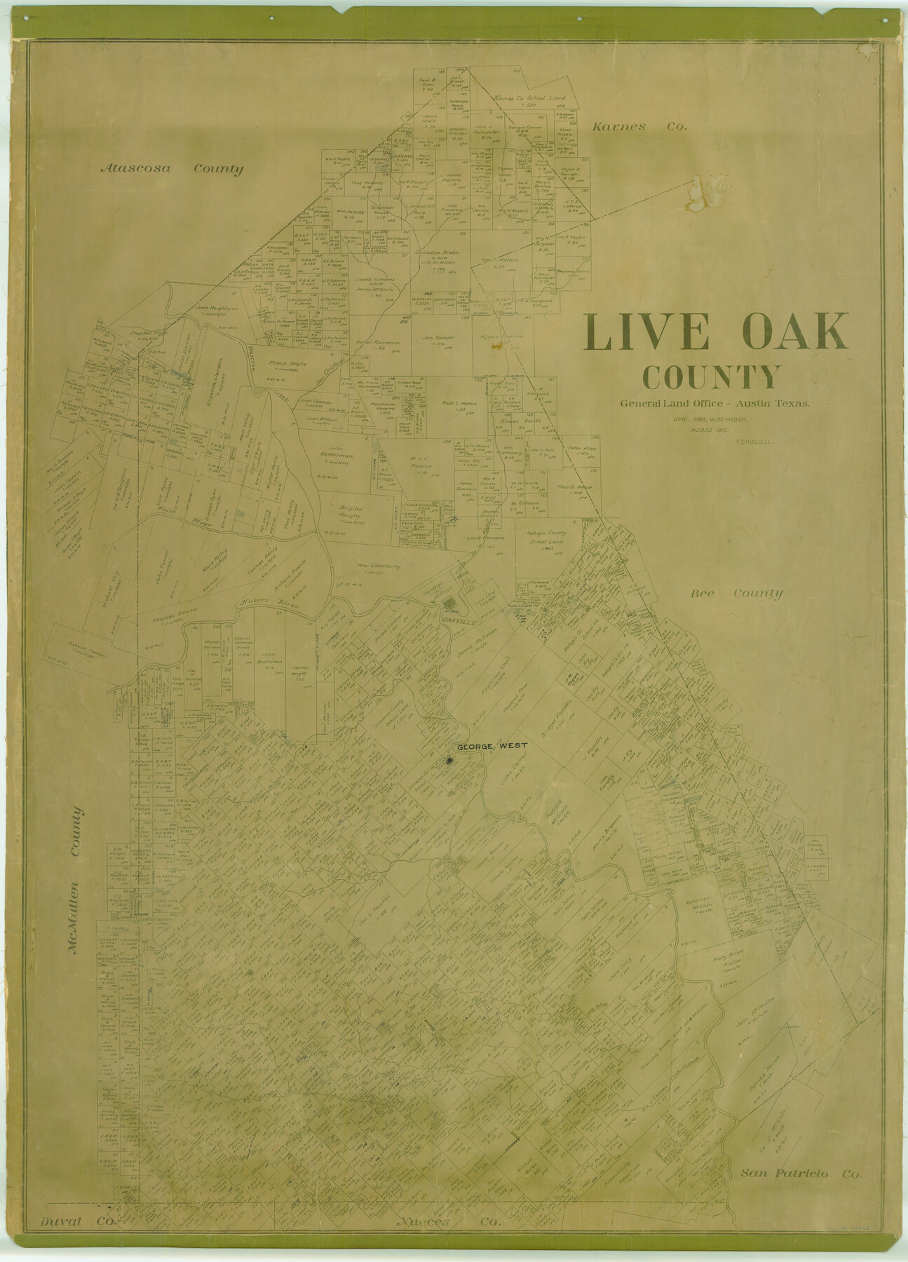
Live Oak County
-
Map/Doc
78423
-
Collection
General Map Collection
-
Object Dates
1899 (Creation Date)
-
People and Organizations
Texas General Land Office (Publisher)
Wise - Hedick (Draftsman)
Wise-Hedick (Compiler)
-
Counties
Live Oak
-
Subjects
County
-
Height x Width
52.1 x 37.5 inches
132.3 x 95.3 cm
-
Features
Atascosa Creek
San Christoval Creek
Puerta de la Piedra [Creek]
Frio River
Three Rivers
Oakville
Nueces River
George West
Spring Creek
Lomo Blanco [Mountain]
Long Hollow [Creek]
Carrcuso Creek
Lagarto
Arroyo Lagardo
Part of: General Map Collection
Hill County Sketch File 8a

Print $4.00
- Digital $50.00
Hill County Sketch File 8a
1858
Size 10.2 x 8.1 inches
Map/Doc 26474
Concho County Sketch File 45

Print $6.00
- Digital $50.00
Concho County Sketch File 45
1958
Size 11.2 x 8.8 inches
Map/Doc 19210
Comanche County Working Sketch 16

Print $20.00
- Digital $50.00
Comanche County Working Sketch 16
1969
Size 16.5 x 23.8 inches
Map/Doc 68150
Pass Cavallo, Entrance to Matagorda Bay, Texas

Print $20.00
- Digital $50.00
Pass Cavallo, Entrance to Matagorda Bay, Texas
1882
Size 24.3 x 18.7 inches
Map/Doc 73375

Matagorda County Rolled Sketch 18

Print $20.00
- Digital $50.00
Matagorda County Rolled Sketch 18
1838
Size 35.7 x 30.8 inches
Map/Doc 6685
Hemphill County Working Sketch 30

Print $40.00
- Digital $50.00
Hemphill County Working Sketch 30
1974
Size 52.5 x 26.7 inches
Map/Doc 66125
Fractional Township No. 8 South Range No. 23 East of the Indian Meridian, Indian Territory

Print $20.00
- Digital $50.00
Fractional Township No. 8 South Range No. 23 East of the Indian Meridian, Indian Territory
1898
Size 19.1 x 24.3 inches
Map/Doc 75249
Montgomery County Working Sketch 16

Print $20.00
- Digital $50.00
Montgomery County Working Sketch 16
1934
Size 28.9 x 33.7 inches
Map/Doc 71123
Travis County Working Sketch 11

Print $20.00
- Digital $50.00
Travis County Working Sketch 11
1919
Size 28.3 x 22.3 inches
Map/Doc 69395
Kleberg County Rolled Sketch 10-18

Print $20.00
- Digital $50.00
Kleberg County Rolled Sketch 10-18
1952
Size 37.3 x 38.2 inches
Map/Doc 9364
Tarrant County Working Sketch 23

Print $20.00
- Digital $50.00
Tarrant County Working Sketch 23
2001
Size 15.9 x 15.6 inches
Map/Doc 62440
You may also like
Nacogdoches County Sketch File 14

Print $42.00
- Digital $50.00
Nacogdoches County Sketch File 14
1926
Size 8.8 x 11.3 inches
Map/Doc 32259
Shelby County Rolled Sketch 8

Print $20.00
- Digital $50.00
Shelby County Rolled Sketch 8
Size 40.4 x 45.5 inches
Map/Doc 9923
Starr County Working Sketch 11

Print $20.00
- Digital $50.00
Starr County Working Sketch 11
1944
Size 18.1 x 17.7 inches
Map/Doc 63927
Hall County Sketch File 32

Print $14.00
- Digital $50.00
Hall County Sketch File 32
1911
Size 11.2 x 8.8 inches
Map/Doc 24839
Right of Way and Track Map - Houston & Texas Central R.R. operated by the T. and N. O. R.R. Co. - Main Line

Print $40.00
- Digital $50.00
Right of Way and Track Map - Houston & Texas Central R.R. operated by the T. and N. O. R.R. Co. - Main Line
1918
Size 25.0 x 57.5 inches
Map/Doc 82857
Wise County Working Sketch 20

Print $20.00
- Digital $50.00
Wise County Working Sketch 20
1979
Size 22.8 x 27.3 inches
Map/Doc 72634
Garza County Sketch File 15

Print $20.00
- Digital $50.00
Garza County Sketch File 15
1902
Size 16.8 x 14.7 inches
Map/Doc 11545
Coke County Working Sketch 1

Print $20.00
- Digital $50.00
Coke County Working Sketch 1
Size 16.3 x 36.2 inches
Map/Doc 68038
Culberson County Sketch File 10a

Print $20.00
- Digital $50.00
Culberson County Sketch File 10a
1926
Size 11.9 x 18.3 inches
Map/Doc 11264
Maps of Gulf Intracoastal Waterway, Texas - Sabine River to the Rio Grande and connecting waterways including ship channels

Print $20.00
- Digital $50.00
Maps of Gulf Intracoastal Waterway, Texas - Sabine River to the Rio Grande and connecting waterways including ship channels
1966
Size 14.6 x 21.7 inches
Map/Doc 61981
Flight Mission No. DAG-21K, Frame 87, Matagorda County

Print $20.00
- Digital $50.00
Flight Mission No. DAG-21K, Frame 87, Matagorda County
1952
Size 18.5 x 22.4 inches
Map/Doc 86416
Gray County Sketch File B3

Print $8.00
- Digital $50.00
Gray County Sketch File B3
1880
Size 13.0 x 8.5 inches
Map/Doc 24411