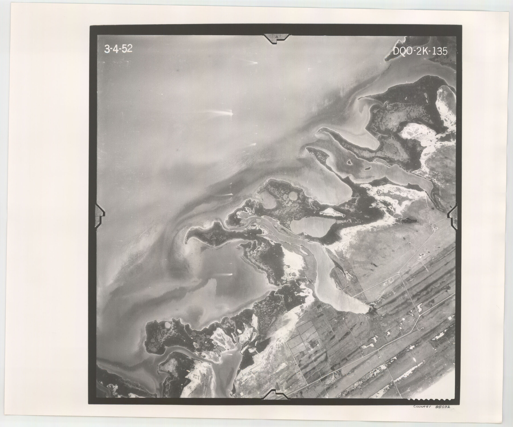
Flight Mission No. DQO-2K, Frame 135, Galveston County
DQO-2K-135
- 
                          Map/Doc
85032
 - 
                            Collection
General Map Collection
 - 
                            Object Dates
1952/3/4 (Creation Date)
 - 
                            People and Organizations
U. S. Department of Agriculture (Publisher)
 - 
                            Counties
Galveston
 - 
                            Subjects
Aerial Photograph
 - 
                            Height x Width
18.7 x 22.5 inches
47.5 x 57.2 cm
 - 
                            Comments
Flown by Aero Exploration Company of Tulsa, Oklahoma.
 
Part of: General Map Collection
            Reeves County Working Sketch 17


                                            Print $20.00                    
                                             -                         Digital $50.00                                    
                Reeves County Working Sketch 17
1961
Size 30.2 x 30.9 inches
                                Map/Doc 63460
            
            Map of Lee County Texas


                                            Print $20.00                    
                                             -                         Digital $50.00                                    
                Map of Lee County Texas
1879
Size 26.2 x 18.0 inches
                                Map/Doc 4578
            
            Brazoria County Sketch File 52


                                            Print $6.00                    
                                             -                         Digital $50.00                                    
                Brazoria County Sketch File 52
Size 14.5 x 8.0 inches
                                Map/Doc 15313
            
            [Surveys between the Lavaca River and Arenosa Creek]


                                            Print $20.00                    
                                             -                         Digital $50.00                                    
                [Surveys between the Lavaca River and Arenosa Creek]
1840
Size 25.6 x 18.9 inches
                                Map/Doc 3184
            
            Current Miscellaneous File 111


                                            Print $8.00                    
                                             -                         Digital $50.00                                    
                Current Miscellaneous File 111
1996
Size 11.3 x 8.7 inches
                                Map/Doc 74714
            
            Flight Mission No. DCL-6C, Frame 8, Kenedy County


                                            Print $20.00                    
                                             -                         Digital $50.00                                    
                Flight Mission No. DCL-6C, Frame 8, Kenedy County
1943
Size 18.5 x 22.5 inches
                                Map/Doc 85868
            
            Terrell County Rolled Sketch 36


                                            Print $20.00                    
                                             -                         Digital $50.00                                    
                Terrell County Rolled Sketch 36
1940
Size 17.4 x 33.8 inches
                                Map/Doc 9989
            
            Nueces Bay and Adjoining Areas showing submerged Lands


                                            Print $40.00                    
                                             -                         Digital $50.00                                    
                Nueces Bay and Adjoining Areas showing submerged Lands
1946
Size 34.6 x 56.4 inches
                                Map/Doc 1916
            
            Marion County Sketch File 17


                                            Print $20.00                    
                                             -                         Digital $50.00                                    
                Marion County Sketch File 17
Size 32.7 x 19.0 inches
                                Map/Doc 12026
            
            Loving County Working Sketch 12


                                            Print $40.00                    
                                             -                         Digital $50.00                                    
                Loving County Working Sketch 12
1957
Size 48.1 x 37.1 inches
                                Map/Doc 70645
            
            Comanche County Rolled Sketch 1


                                            Print $20.00                    
                                             -                         Digital $50.00                                    
                Comanche County Rolled Sketch 1
1985
Size 24.1 x 18.7 inches
                                Map/Doc 5542
            You may also like
            Tarrant County Sketch File 17


                                            Print $8.00                    
                                             -                         Digital $50.00                                    
                Tarrant County Sketch File 17
1860
Size 8.3 x 8.1 inches
                                Map/Doc 37716
            
            Hardin County Sketch File 68


                                            Print $20.00                    
                                             -                         Digital $50.00                                    
                Hardin County Sketch File 68
1948
Size 23.9 x 21.4 inches
                                Map/Doc 11640
            
            [Map showing T&P Lands in El Paso County]


                                            Print $20.00                    
                                    
                [Map showing T&P Lands in El Paso County]
Size 22.3 x 17.3 inches
                                Map/Doc 88937
            
            Matagorda County Sketch File 17


                                            Print $20.00                    
                                             -                         Digital $50.00                                    
                Matagorda County Sketch File 17
1877
Size 16.4 x 14.5 inches
                                Map/Doc 12040
            
            Kimble County Working Sketch 50


                                            Print $20.00                    
                                             -                         Digital $50.00                                    
                Kimble County Working Sketch 50
1952
Size 34.8 x 22.1 inches
                                Map/Doc 70118
            
            Winkler County Sketch File 1 and 2


                                            Print $64.00                    
                                             -                         Digital $50.00                                    
                Winkler County Sketch File 1 and 2
1900
Size 8.4 x 9.2 inches
                                Map/Doc 40431
            
            Hutchinson County Sketch File 44


                                            Print $82.00                    
                                             -                         Digital $50.00                                    
                Hutchinson County Sketch File 44
1989
Size 11.2 x 9.0 inches
                                Map/Doc 27311
            
            Upton County Boundary File 1


                                            Print $5.00                    
                                             -                         Digital $50.00                                    
                Upton County Boundary File 1
Size 13.4 x 9.0 inches
                                Map/Doc 59506
            
            Hydrography of Sabine Pass and Lake, La. And Tex.


                                            Print $40.00                    
                                             -                         Digital $50.00                                    
                Hydrography of Sabine Pass and Lake, La. And Tex.
1885
Size 53.2 x 32.5 inches
                                Map/Doc 2085
            
            Williamson County Boundary File 4


                                            Print $40.00                    
                                             -                         Digital $50.00                                    
                Williamson County Boundary File 4
Size 8.3 x 13.3 inches
                                Map/Doc 60013
            
            Flight Mission No. DAG-24K, Frame 51, Matagorda County


                                            Print $20.00                    
                                             -                         Digital $50.00                                    
                Flight Mission No. DAG-24K, Frame 51, Matagorda County
1953
Size 16.0 x 15.9 inches
                                Map/Doc 86538
            
            City of Round Rock, Texas


                                            Print $20.00                    
                                    
                City of Round Rock, Texas
1958
Size 25.3 x 31.5 inches
                                Map/Doc 87359