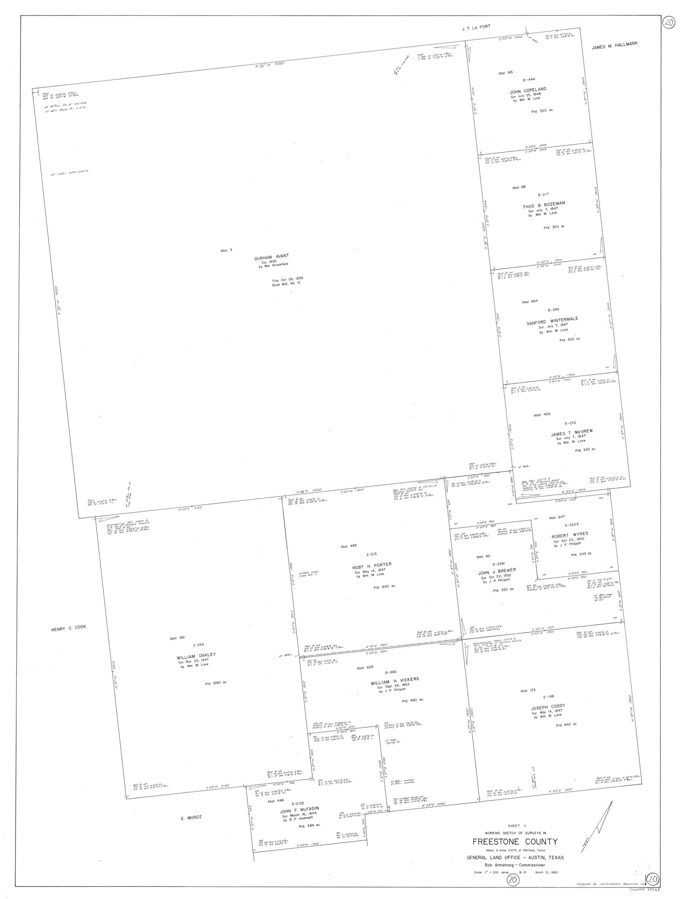
Freestone County Working Sketch 20
-
Map/Doc
69262
-
Collection
General Map Collection
-
Object Dates
3/12/1980 (Creation Date)
-
People and Organizations
Beverly Robison (Draftsman)
-
Counties
Freestone
-
Subjects
Surveying Working Sketch
-
Height x Width
52.4 x 39.6 inches
133.1 x 100.6 cm
-
Scale
1" = 200 varas
Part of: General Map Collection
Kinney County Working Sketch 56

Print $40.00
- Digital $50.00
Kinney County Working Sketch 56
1987
Size 40.5 x 62.8 inches
Map/Doc 70238
Crane County State of Texas

Print $20.00
- Digital $50.00
Crane County State of Texas
1889
Size 22.9 x 17.6 inches
Map/Doc 4524
Sutton County Sketch File 59

Print $20.00
- Digital $50.00
Sutton County Sketch File 59
Size 24.6 x 16.5 inches
Map/Doc 12394
Morris County Rolled Sketch 2

Print $40.00
- Digital $50.00
Morris County Rolled Sketch 2
1944
Size 59.4 x 43.5 inches
Map/Doc 9550

Pecos County Sketch File 37

Print $4.00
- Digital $50.00
Pecos County Sketch File 37
1911
Size 8.9 x 8.3 inches
Map/Doc 33718
Coke County Rolled Sketch 24

Print $20.00
- Digital $50.00
Coke County Rolled Sketch 24
Size 35.8 x 33.8 inches
Map/Doc 8633
Duval County Sketch File 51

Print $20.00
- Digital $50.00
Duval County Sketch File 51
Size 19.1 x 33.8 inches
Map/Doc 11401
Aransas County Rolled Sketch 19

Print $20.00
- Digital $50.00
Aransas County Rolled Sketch 19
1979
Size 24.8 x 36.7 inches
Map/Doc 82559
Flight Mission No. DQN-3K, Frame 63, Calhoun County

Print $20.00
- Digital $50.00
Flight Mission No. DQN-3K, Frame 63, Calhoun County
1953
Size 18.4 x 22.3 inches
Map/Doc 84354
A Map of Part of Matagorda Peninsula and the Main-land Opposite State of Texas

Print $40.00
- Digital $50.00
A Map of Part of Matagorda Peninsula and the Main-land Opposite State of Texas
1855
Size 32.4 x 62.7 inches
Map/Doc 69979
W. M. Kuykendall Ranch, Matagorda County, Texas

Print $20.00
- Digital $50.00
W. M. Kuykendall Ranch, Matagorda County, Texas
1926
Size 24.3 x 39.6 inches
Map/Doc 3028
You may also like
Knox County Sketch File 28

Print $20.00
- Digital $50.00
Knox County Sketch File 28
Size 43.4 x 38.3 inches
Map/Doc 10516

Flight Mission No. CGI-4N, Frame 159, Cameron County

Print $20.00
- Digital $50.00
Flight Mission No. CGI-4N, Frame 159, Cameron County
1955
Size 18.7 x 22.2 inches
Map/Doc 84667
Map of Scurry County

Print $20.00
- Digital $50.00
Map of Scurry County
1899
Size 39.8 x 34.7 inches
Map/Doc 63029
Refugio County Working Sketch 4

Print $20.00
- Digital $50.00
Refugio County Working Sketch 4
1937
Size 33.2 x 31.4 inches
Map/Doc 63513
Harris County Working Sketch 72

Print $20.00
- Digital $50.00
Harris County Working Sketch 72
1958
Size 24.9 x 43.6 inches
Map/Doc 65964
Flight Mission No. CGI-3N, Frame 100, Cameron County

Print $20.00
- Digital $50.00
Flight Mission No. CGI-3N, Frame 100, Cameron County
1954
Size 18.6 x 22.3 inches
Map/Doc 84580
City of Austin, Texas Use District Map

Print $20.00
- Digital $50.00
City of Austin, Texas Use District Map
1939
Size 42.9 x 32.2 inches
Map/Doc 452
General Highway Map, Denton County, Texas

Print $20.00
General Highway Map, Denton County, Texas
1939
Size 18.5 x 25.3 inches
Map/Doc 79074
Kinney County Working Sketch 37

Print $20.00
- Digital $50.00
Kinney County Working Sketch 37
1971
Size 25.7 x 21.7 inches
Map/Doc 70219
North Sulphur River, Ben Franklin Sheet

Print $40.00
- Digital $50.00
North Sulphur River, Ben Franklin Sheet
1928
Size 24.6 x 57.4 inches
Map/Doc 65172
Map of Stephens County

Print $20.00
- Digital $50.00
Map of Stephens County
1897
Size 42.8 x 37.5 inches
Map/Doc 78394