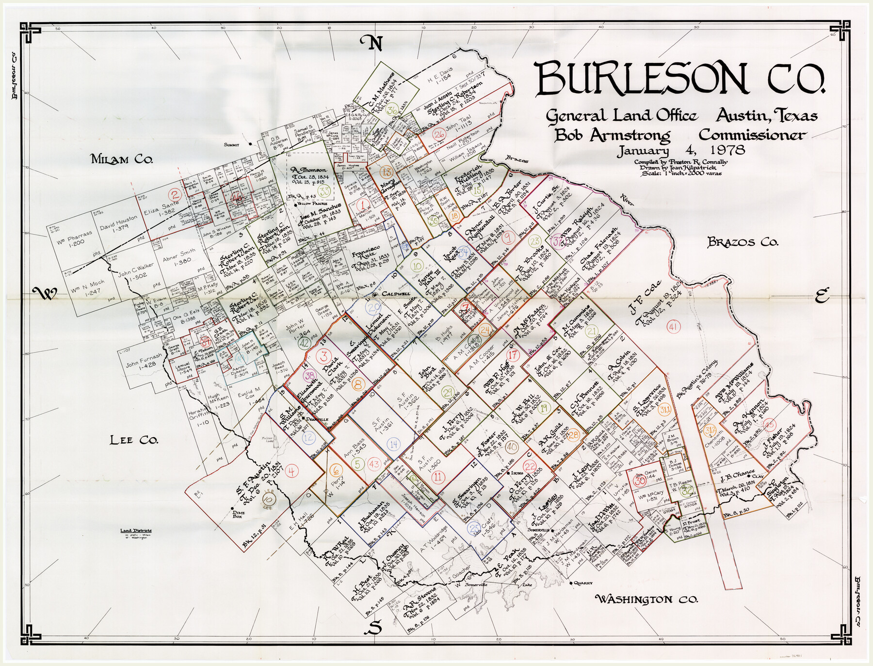
Burleson County Working Sketch Graphic Index
-
Map/Doc
76481
-
Collection
General Map Collection
-
Object Dates
1/4/1978 (Creation Date)
-
People and Organizations
Preston R. Connally (Compiler)
Joan Kilpatrick (Draftsman)
-
Counties
Burleson
-
Subjects
County Surveying Working Sketch
-
Height x Width
35.0 x 46.1 inches
88.9 x 117.1 cm
-
Scale
1" = 2000 varas
Part of: General Map Collection
Dimmit County Sketch File 38

Print $40.00
- Digital $50.00
Dimmit County Sketch File 38
1896
Size 14.8 x 16.9 inches
Map/Doc 21163
Baylor County Rolled Sketch 12

Print $20.00
- Digital $50.00
Baylor County Rolled Sketch 12
1986
Size 22.4 x 36.0 inches
Map/Doc 5129

Gulf Coast of the United States, Key West to Rio Grande

Print $20.00
- Digital $50.00
Gulf Coast of the United States, Key West to Rio Grande
1863
Size 27.4 x 18.3 inches
Map/Doc 72666
Upton County Rolled Sketch 36A

Print $40.00
- Digital $50.00
Upton County Rolled Sketch 36A
1952
Size 43.5 x 65.8 inches
Map/Doc 10661
Texas Intracoastal Waterway - Port O'Connor to San Antonio Bay, Including Pass Cavallo

Print $20.00
- Digital $50.00
Texas Intracoastal Waterway - Port O'Connor to San Antonio Bay, Including Pass Cavallo
1961
Size 26.4 x 38.8 inches
Map/Doc 73374
McMullen County Working Sketch 57

Print $20.00
- Digital $50.00
McMullen County Working Sketch 57
1983
Size 29.5 x 18.8 inches
Map/Doc 70758
Victoria County Sketch File 8

Print $2.00
- Digital $50.00
Victoria County Sketch File 8
Size 5.7 x 5.6 inches
Map/Doc 39524
San Augustine County Working Sketch 27

Print $20.00
- Digital $50.00
San Augustine County Working Sketch 27
2009
Size 30.4 x 31.3 inches
Map/Doc 89020
[Map of the City of South Padre Island]
![3212, [Map of the City of South Padre Island], General Map Collection](https://historictexasmaps.com/wmedia_w700/maps/3212-1.tif.jpg)
Print $20.00
- Digital $50.00
[Map of the City of South Padre Island]
1993
Size 12.5 x 36.5 inches
Map/Doc 3212
Angelina County, Nacogdoches District

Print $20.00
- Digital $50.00
Angelina County, Nacogdoches District
1882
Size 20.0 x 27.6 inches
Map/Doc 3234
Jefferson County Sketch File 54

Print $226.00
- Digital $50.00
Jefferson County Sketch File 54
1961
Size 11.0 x 8.5 inches
Map/Doc 28359
You may also like
Nolan County Sketch File 13

Print $20.00
- Digital $50.00
Nolan County Sketch File 13
1886
Size 17.8 x 29.9 inches
Map/Doc 42207
Rusk County Rolled Sketch OBS

Print $20.00
- Digital $50.00
Rusk County Rolled Sketch OBS
1937
Size 26.3 x 21.8 inches
Map/Doc 7550
Map of Wilbarger County Young Land District formerly Fannin Land District

Print $20.00
- Digital $50.00
Map of Wilbarger County Young Land District formerly Fannin Land District
1859
Size 22.7 x 20.6 inches
Map/Doc 4146
Map of Texas with Parts of the Adjoining States

Print $20.00
Map of Texas with Parts of the Adjoining States
1833
Size 29.3 x 23.3 inches
Map/Doc 79740
Reeves County Working Sketch 5

Print $20.00
- Digital $50.00
Reeves County Working Sketch 5
1938
Size 38.0 x 32.4 inches
Map/Doc 63448
[Surveys along the Frio River at the confluence of the Sabinal River]
![78372, [Surveys along the Frio River at the confluence of the Sabinal River], General Map Collection](https://historictexasmaps.com/wmedia_w700/maps/78372.tif.jpg)
Print $2.00
- Digital $50.00
[Surveys along the Frio River at the confluence of the Sabinal River]
1845
Size 6.2 x 8.9 inches
Map/Doc 78372
Liberty County Working Sketch 54

Print $20.00
- Digital $50.00
Liberty County Working Sketch 54
1962
Size 29.8 x 29.5 inches
Map/Doc 70514
Rusk County Sketch File 11

Print $4.00
Rusk County Sketch File 11
1849
Size 8.5 x 9.1 inches
Map/Doc 35509
Panola County Sketch File 18

Print $20.00
- Digital $50.00
Panola County Sketch File 18
1909
Size 24.2 x 18.7 inches
Map/Doc 12138
Flight Mission No. DQN-2K, Frame 140, Calhoun County

Print $20.00
- Digital $50.00
Flight Mission No. DQN-2K, Frame 140, Calhoun County
1953
Size 17.2 x 15.9 inches
Map/Doc 84309
Sterling County Rolled Sketch 37

Print $20.00
- Digital $50.00
Sterling County Rolled Sketch 37
Size 13.7 x 16.6 inches
Map/Doc 7862
McClennan County Robertson District East of the Brazos Milam District West of the Brazos

Print $20.00
- Digital $50.00
McClennan County Robertson District East of the Brazos Milam District West of the Brazos
1877
Size 21.9 x 24.5 inches
Map/Doc 3864