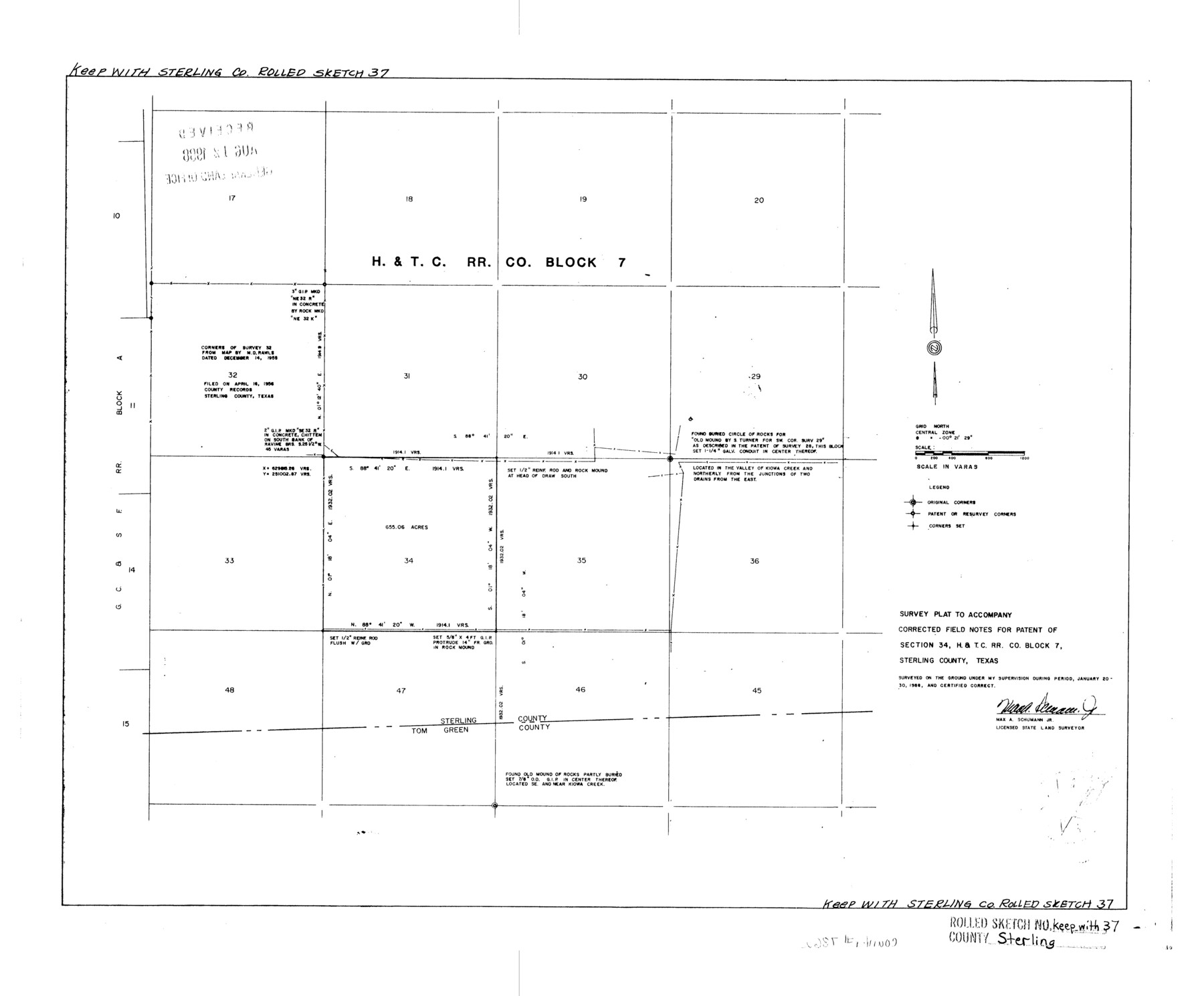
Sterling County Rolled Sketch 37
Survey plat to accompany corrected field notes for patent of section 34, H. & T. C. R.R. Co. Block 7, Sterling County, Texas
-
Map/Doc
7862
-
Collection
General Map Collection
-
Object Dates
1988/1/30 (Survey Date)
1988/8/12 (File Date)
-
People and Organizations
Max A. Schumann, Jr. (Surveyor/Engineer)
-
Counties
Sterling
-
Subjects
Surveying Rolled Sketch
-
Height x Width
13.7 x 16.6 inches
34.8 x 42.2 cm
-
Medium
mylar, print
Part of: General Map Collection
[Map of Upshur County]
![[Map of Upshur County]](https://historictexasmaps.com/wmedia_w700/maps/4651.tif.jpg)
Print $20.00
- Digital $50.00
[Map of Upshur County]
1850
Size 25.2 x 17.8 inches
Map/Doc 4651
Ward County Rolled Sketch 9

Print $40.00
- Digital $50.00
Ward County Rolled Sketch 9
1936
Size 51.5 x 41.9 inches
Map/Doc 10105
Gregg County Boundary File 7

Print $20.00
- Digital $50.00
Gregg County Boundary File 7
Size 5.2 x 8.6 inches
Map/Doc 54009
Nueces County Sketch File 80

Print $102.00
- Digital $50.00
Nueces County Sketch File 80
1997
Size 11.0 x 8.5 inches
Map/Doc 33104
Nueces County Sketch File 68

Print $8.00
- Digital $50.00
Nueces County Sketch File 68
Size 11.0 x 8.7 inches
Map/Doc 33000
San Patricio County Sketch File 50

Print $8.00
- Digital $50.00
San Patricio County Sketch File 50
1873
Size 14.4 x 8.8 inches
Map/Doc 36371
Rusk County Sketch File 10

Print $4.00
Rusk County Sketch File 10
1849
Size 8.1 x 7.3 inches
Map/Doc 35507
Lubbock County Working Sketch 4
Print $20.00
- Digital $50.00
Lubbock County Working Sketch 4
1947
Size 31.8 x 36.8 inches
Map/Doc 70664
Atascosa County Boundary File 3

Print $18.00
- Digital $50.00
Atascosa County Boundary File 3
Size 8.7 x 8.5 inches
Map/Doc 50168
Lampasas County Working Sketch 3

Print $20.00
- Digital $50.00
Lampasas County Working Sketch 3
1941
Size 25.0 x 14.6 inches
Map/Doc 70280
Liberty County Working Sketch 57

Print $40.00
- Digital $50.00
Liberty County Working Sketch 57
1967
Size 52.6 x 40.6 inches
Map/Doc 70517
Map of Jasper District

Print $20.00
- Digital $50.00
Map of Jasper District
1847
Size 32.8 x 29.6 inches
Map/Doc 3713
You may also like
Harris County Rolled Sketch 86

Print $20.00
- Digital $50.00
Harris County Rolled Sketch 86
1933
Size 33.5 x 32.4 inches
Map/Doc 73575
Hardin County

Print $20.00
- Digital $50.00
Hardin County
1940
Size 40.7 x 37.7 inches
Map/Doc 77303
San Luis Pass to East Matagorda Bay

Print $40.00
- Digital $50.00
San Luis Pass to East Matagorda Bay
1982
Size 35.6 x 49.3 inches
Map/Doc 69970
Knox County Sketch File 7

Print $40.00
- Digital $50.00
Knox County Sketch File 7
1885
Size 32.2 x 19.9 inches
Map/Doc 11955
Arlancy the Land of Plenty Farms

Print $20.00
- Digital $50.00
Arlancy the Land of Plenty Farms
1925
Size 10.8 x 16.6 inches
Map/Doc 96738
El Paso County Rolled Sketch 18

Print $20.00
- Digital $50.00
El Paso County Rolled Sketch 18
Size 30.0 x 33.4 inches
Map/Doc 5822

A Map of the British Empire in America with the French and Spanish Settlements adjacent thereto

Print $20.00
- Digital $50.00
A Map of the British Empire in America with the French and Spanish Settlements adjacent thereto
Size 20.7 x 20.6 inches
Map/Doc 95704
Val Verde County Working Sketch 28

Print $20.00
- Digital $50.00
Val Verde County Working Sketch 28
1937
Size 45.9 x 38.6 inches
Map/Doc 72163
Kerr County Rolled Sketch 19

Print $20.00
- Digital $50.00
Kerr County Rolled Sketch 19
1954
Size 43.4 x 28.4 inches
Map/Doc 6501
Zavala County Rolled Sketch 16

Print $20.00
- Digital $50.00
Zavala County Rolled Sketch 16
Size 19.4 x 25.4 inches
Map/Doc 8321
Edwards County Sketch File 23

Print $8.00
- Digital $50.00
Edwards County Sketch File 23
1881
Size 14.4 x 9.0 inches
Map/Doc 21747