Baylor County Rolled Sketch 12
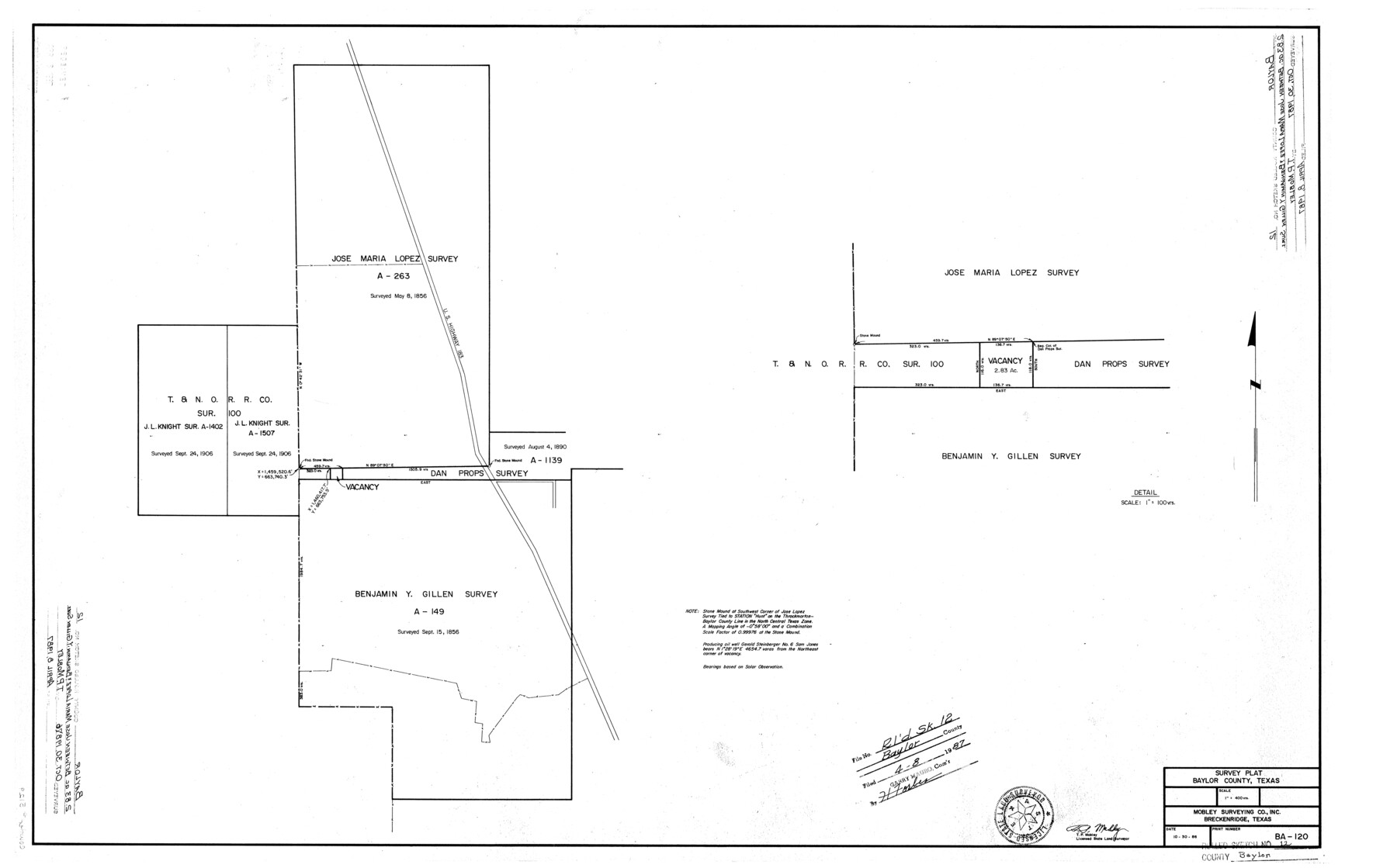
[Plat of 2.83 ac. between Jose Maria Lopez survey and Benjamin Y. Gillen survey - SF-16495]
-
Map/Doc
5129
-
Collection
General Map Collection
-
Object Dates
1986/10/30 (Creation Date)
1987/4/8 (File Date)
-
People and Organizations
T.P. Mobley (Surveyor/Engineer)
-
Counties
Baylor
-
Subjects
Surveying Rolled Sketch
-
Height x Width
22.4 x 36.0 inches
56.9 x 91.4 cm
-
Medium
mylar, print
-
Scale
1" = 400 varas
Part of: General Map Collection
Gaines County Rolled Sketch 9

Print $20.00
- Digital $50.00
Gaines County Rolled Sketch 9
Size 20.9 x 29.8 inches
Map/Doc 5929
Val Verde County Rolled Sketch 1

Print $40.00
- Digital $50.00
Val Verde County Rolled Sketch 1
1885
Size 69.8 x 39.1 inches
Map/Doc 10068
Val Verde County Rolled Sketch 67

Print $20.00
- Digital $50.00
Val Verde County Rolled Sketch 67
1958
Size 24.5 x 31.6 inches
Map/Doc 8130
Runnels County Working Sketch 15

Print $20.00
- Digital $50.00
Runnels County Working Sketch 15
1950
Size 22.8 x 18.5 inches
Map/Doc 63611
Floyd County Sketch File 22

Print $4.00
- Digital $50.00
Floyd County Sketch File 22
Size 8.8 x 8.0 inches
Map/Doc 22774
San Augustine County Working Sketch 11a

Print $20.00
- Digital $50.00
San Augustine County Working Sketch 11a
Size 18.8 x 24.4 inches
Map/Doc 63698
Flight Mission No. DIX-5P, Frame 118, Aransas County

Print $20.00
- Digital $50.00
Flight Mission No. DIX-5P, Frame 118, Aransas County
1956
Size 17.7 x 17.8 inches
Map/Doc 83797
Culberson County Rolled Sketch 64

Print $20.00
- Digital $50.00
Culberson County Rolled Sketch 64
1987
Size 24.3 x 19.4 inches
Map/Doc 5680
Gaines County Working Sketch 26

Print $20.00
- Digital $50.00
Gaines County Working Sketch 26
1983
Size 34.1 x 39.7 inches
Map/Doc 69326
Liberty County Working Sketch 81

Print $20.00
- Digital $50.00
Liberty County Working Sketch 81
1981
Size 8.0 x 24.2 inches
Map/Doc 70541
Live Oak County Sketch File 20

Print $14.00
- Digital $50.00
Live Oak County Sketch File 20
1898
Size 11.4 x 8.8 inches
Map/Doc 30290
Coke County Sketch File 25

Print $34.00
- Digital $50.00
Coke County Sketch File 25
1930
Size 14.2 x 8.9 inches
Map/Doc 18618
You may also like

Trinity River, Bazzette Sheet

Print $20.00
- Digital $50.00
Trinity River, Bazzette Sheet
1925
Size 27.9 x 23.8 inches
Map/Doc 78339
Goliad County Sketch File 8

Print $4.00
- Digital $50.00
Goliad County Sketch File 8
1848
Size 9.0 x 11.1 inches
Map/Doc 24221
Pas Kaart van de Golff van Mexico

Print $20.00
- Digital $50.00
Pas Kaart van de Golff van Mexico
1695
Size 21.4 x 25.4 inches
Map/Doc 94081
Old Miscellaneous File 10

Print $4.00
- Digital $50.00
Old Miscellaneous File 10
Size 9.6 x 8.2 inches
Map/Doc 75435
Liberty County Working Sketch 21

Print $20.00
- Digital $50.00
Liberty County Working Sketch 21
1940
Size 20.1 x 15.0 inches
Map/Doc 70480
Kimble County Sketch File A

Print $20.00
- Digital $50.00
Kimble County Sketch File A
1895
Size 17.9 x 18.7 inches
Map/Doc 11933
Flight Mission No. CRE-1R, Frame 134, Jackson County

Print $20.00
- Digital $50.00
Flight Mission No. CRE-1R, Frame 134, Jackson County
1956
Size 16.2 x 16.0 inches
Map/Doc 85342
S.B. Burnett's King County Ranch

Print $20.00
- Digital $50.00
S.B. Burnett's King County Ranch
1902
Size 32.3 x 30.6 inches
Map/Doc 4441
Map of Hidalgo County

Print $20.00
- Digital $50.00
Map of Hidalgo County
1880
Size 45.3 x 25.1 inches
Map/Doc 3667
Lee County Working Sketch 12

Print $20.00
- Digital $50.00
Lee County Working Sketch 12
1980
Size 12.3 x 16.3 inches
Map/Doc 70391
Coast Chart No. 211 - Padre I. and Laguna Madre Lat. 27° 12' to Lat. 26° 33' Texas

Print $20.00
- Digital $50.00
Coast Chart No. 211 - Padre I. and Laguna Madre Lat. 27° 12' to Lat. 26° 33' Texas
1890
Size 27.5 x 18.3 inches
Map/Doc 72823