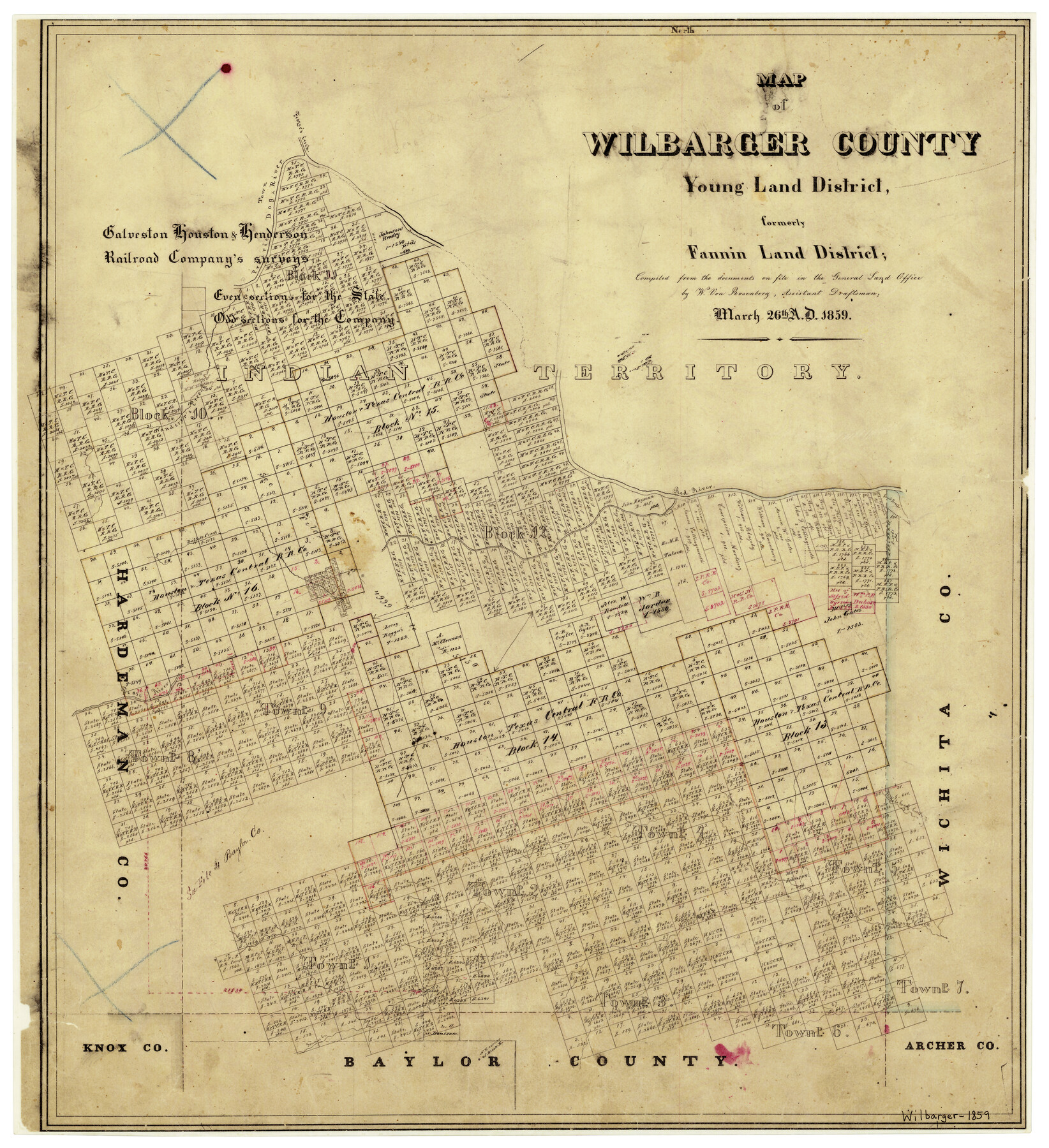
Map of Wilbarger County Young Land District formerly Fannin Land District
-
Map/Doc
4146
-
Collection
General Map Collection
-
Object Dates
3/26/1859 (Creation Date)
-
People and Organizations
W. von Rosenberg (Compiler)
-
Counties
Wilbarger
-
Subjects
County
-
Height x Width
22.7 x 20.6 inches
57.7 x 52.3 cm
-
Features
Frazer's Creek
Prairie Dog Town River
Wanderer's Creek
Buffalo Creek
Red River
Pease River
Buffalohead Creek
Minna's Creek
Jennie's Creek
Bennie's Creek
Emma's Creek
Beaver Creek
Part of: General Map Collection
Lee County Rolled Sketch 1

Print $40.00
- Digital $50.00
Lee County Rolled Sketch 1
1939
Size 71.1 x 45.2 inches
Map/Doc 9562
Hutchinson County Working Sketch 1

Print $3.00
- Digital $50.00
Hutchinson County Working Sketch 1
Size 9.5 x 17.0 inches
Map/Doc 66359
San Jacinto County Working Sketch 17

Print $40.00
- Digital $50.00
San Jacinto County Working Sketch 17
1934
Size 36.6 x 48.2 inches
Map/Doc 63730
Chart of the West Indies and Spanish Dominions in North America

Print $20.00
- Digital $50.00
Chart of the West Indies and Spanish Dominions in North America
1803
Size 25.5 x 38.9 inches
Map/Doc 97139
Colorado County

Print $20.00
- Digital $50.00
Colorado County
1847
Size 23.7 x 31.4 inches
Map/Doc 3424
Brewster County Rolled Sketch 114

Print $20.00
- Digital $50.00
Brewster County Rolled Sketch 114
1964
Size 12.0 x 18.4 inches
Map/Doc 5278
Brewster County Working Sketch 103

Print $40.00
- Digital $50.00
Brewster County Working Sketch 103
1980
Size 48.4 x 31.1 inches
Map/Doc 67703
Andrews County Rolled Sketch 15

Print $20.00
- Digital $50.00
Andrews County Rolled Sketch 15
1934
Size 27.9 x 22.4 inches
Map/Doc 77166
Flight Mission No. DCL-6C, Frame 173, Kenedy County

Print $20.00
- Digital $50.00
Flight Mission No. DCL-6C, Frame 173, Kenedy County
1943
Size 18.6 x 22.4 inches
Map/Doc 85985
Harris County Historic Topographic 22

Print $20.00
- Digital $50.00
Harris County Historic Topographic 22
1915
Size 29.2 x 22.7 inches
Map/Doc 65833
Wood County Boundary File 2a

Print $6.00
- Digital $50.00
Wood County Boundary File 2a
Size 10.0 x 8.0 inches
Map/Doc 60159
Right of Way and Track Map, Texas & New Orleans R.R. Co. operated by the T. & N. O. R.R. Co., Dallas-Sabine Branch

Print $40.00
- Digital $50.00
Right of Way and Track Map, Texas & New Orleans R.R. Co. operated by the T. & N. O. R.R. Co., Dallas-Sabine Branch
1918
Size 24.6 x 56.4 inches
Map/Doc 64631
You may also like
Frio County Working Sketch 25

Print $40.00
- Digital $50.00
Frio County Working Sketch 25
1989
Size 35.4 x 50.0 inches
Map/Doc 69299
Harris County Rolled Sketch 62

Print $20.00
- Digital $50.00
Harris County Rolled Sketch 62
1930
Size 29.9 x 28.7 inches
Map/Doc 6108
[Blocks XO3 and I]
![91167, [Blocks XO3 and I], Twichell Survey Records](https://historictexasmaps.com/wmedia_w700/maps/91167-1.tif.jpg)
Print $2.00
- Digital $50.00
[Blocks XO3 and I]
Size 6.5 x 11.8 inches
Map/Doc 91167
Duval County Sketch File 78

Print $2.00
- Digital $50.00
Duval County Sketch File 78
1984
Size 14.5 x 8.9 inches
Map/Doc 21468
Armstrong County Sketch File A-8

Print $80.00
- Digital $50.00
Armstrong County Sketch File A-8
Size 21.3 x 33.2 inches
Map/Doc 10850
Coleman County Sketch File 44

Print $17.00
- Digital $50.00
Coleman County Sketch File 44
Size 14.1 x 8.6 inches
Map/Doc 18783
Ladonia, Fannin County, Texas

Print $20.00
Ladonia, Fannin County, Texas
1891
Size 12.3 x 22.3 inches
Map/Doc 93475
Flight Mission No. CGI-3N, Frame 169, Cameron County

Print $20.00
- Digital $50.00
Flight Mission No. CGI-3N, Frame 169, Cameron County
1954
Size 18.6 x 22.3 inches
Map/Doc 84633
[Sketch for Mineral Application 26542 - Sabine River between Prairie and Hawkins Creek, F. B. Jackson, Jr.]
![65669, [Sketch for Mineral Application 26542 - Sabine River between Prairie and Hawkins Creek, F. B. Jackson, Jr.], General Map Collection](https://historictexasmaps.com/wmedia_w700/maps/65669.tif.jpg)
Print $40.00
- Digital $50.00
[Sketch for Mineral Application 26542 - Sabine River between Prairie and Hawkins Creek, F. B. Jackson, Jr.]
1931
Size 22.0 x 64.0 inches
Map/Doc 65669

Cooke County Working Sketch 3

Print $20.00
- Digital $50.00
Cooke County Working Sketch 3
1926
Size 27.5 x 39.9 inches
Map/Doc 68240
