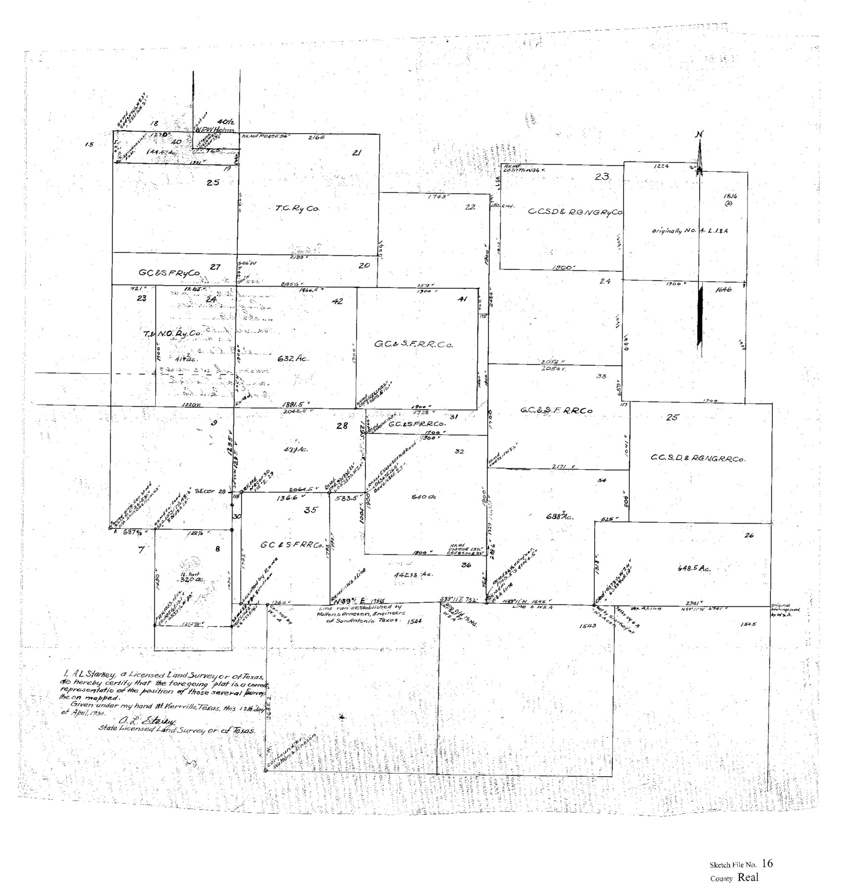
Real County Sketch File 16
[Sketch showing surveys in the central part of Real County near the southwest corner of Kerr County]
-
Map/Doc
12234
-
Collection
General Map Collection
-
Object Dates
4/12/1934 (Creation Date)
7/15/1934 (File Date)
-
People and Organizations
A.L. Starkey (Surveyor/Engineer)
-
Counties
Real Kerr
-
Subjects
Surveying Sketch File
-
Height x Width
23.1 x 22.1 inches
58.7 x 56.1 cm
-
Medium
paper, print
-
Comments
See Real County Sketch File 15 (35069) for surveyor's statement.
Related maps
Real County Sketch File 15

Print $8.00
- Digital $50.00
Real County Sketch File 15
1933
Size 14.3 x 8.6 inches
Map/Doc 35069
Part of: General Map Collection
Rusk County Working Sketch 11

Print $20.00
- Digital $50.00
Rusk County Working Sketch 11
1980
Size 33.3 x 32.0 inches
Map/Doc 63646
Sulphur River, Bassett Sheet

Print $20.00
- Digital $50.00
Sulphur River, Bassett Sheet
1939
Size 23.9 x 31.5 inches
Map/Doc 69683
Marion County Sketch File 1a

Print $3.00
- Digital $50.00
Marion County Sketch File 1a
1867
Size 17.4 x 7.7 inches
Map/Doc 30559
Matagorda County Rolled Sketch 23

Print $20.00
- Digital $50.00
Matagorda County Rolled Sketch 23
1942
Size 25.0 x 23.8 inches
Map/Doc 6690
Uvalde County Working Sketch 19

Print $20.00
- Digital $50.00
Uvalde County Working Sketch 19
1948
Size 25.8 x 39.8 inches
Map/Doc 72089
Flight Mission No. CRE-1R, Frame 121, Jackson County

Print $20.00
- Digital $50.00
Flight Mission No. CRE-1R, Frame 121, Jackson County
1956
Size 16.2 x 16.0 inches
Map/Doc 85332
Anderson County Working Sketch 30

Print $20.00
- Digital $50.00
Anderson County Working Sketch 30
1963
Size 29.8 x 41.6 inches
Map/Doc 67030
Sketch of surveys in Houston Co. on Pine Bayou

Print $2.00
- Digital $50.00
Sketch of surveys in Houston Co. on Pine Bayou
Size 7.7 x 7.6 inches
Map/Doc 69742
Cooke County Working Sketch 12

Print $20.00
- Digital $50.00
Cooke County Working Sketch 12
1944
Size 25.2 x 23.0 inches
Map/Doc 68249
Robertson County Sketch File 10

Print $22.00
Robertson County Sketch File 10
1846
Size 12.8 x 8.4 inches
Map/Doc 35392
Starr County Sketch File 48

Print $20.00
- Digital $50.00
Starr County Sketch File 48
1950
Size 22.3 x 10.8 inches
Map/Doc 12345
Flight Mission No. CGI-4N, Frame 181, Cameron County

Print $20.00
- Digital $50.00
Flight Mission No. CGI-4N, Frame 181, Cameron County
1955
Size 18.2 x 22.4 inches
Map/Doc 84684
You may also like
Lubbock County, Texas

Print $20.00
- Digital $50.00
Lubbock County, Texas
1892
Size 27.8 x 22.6 inches
Map/Doc 565

[Emile Snow Lands and vicinity]
![91147, [Emile Snow Lands and vicinity], Twichell Survey Records](https://historictexasmaps.com/wmedia_w700/maps/91147-1.tif.jpg)
Print $20.00
- Digital $50.00
[Emile Snow Lands and vicinity]
Size 10.7 x 18.9 inches
Map/Doc 91147
Flight Mission No. DCL-7C, Frame 134, Kenedy County

Print $20.00
- Digital $50.00
Flight Mission No. DCL-7C, Frame 134, Kenedy County
1943
Size 18.5 x 22.3 inches
Map/Doc 86091
The Judicial District/County of Madison. Created, February 2, 1842

Print $20.00
The Judicial District/County of Madison. Created, February 2, 1842
2020
Size 18.2 x 21.7 inches
Map/Doc 96333
Die Neüwen Inseln / so hinder Hispanien gegen Orient bey dem Landt Indie ligen

Print $20.00
- Digital $50.00
Die Neüwen Inseln / so hinder Hispanien gegen Orient bey dem Landt Indie ligen
1540
Size 12.3 x 15.6 inches
Map/Doc 93803
[Sketch from Burnet Co. to Baylor Co. tying center of counties to county site]
![1699, [Sketch from Burnet Co. to Baylor Co. tying center of counties to county site], General Map Collection](https://historictexasmaps.com/wmedia_w700/maps/1699.tif.jpg)
Print $40.00
- Digital $50.00
[Sketch from Burnet Co. to Baylor Co. tying center of counties to county site]
1900
Size 132.6 x 31.9 inches
Map/Doc 1699
Gillespie County Working Sketch 3

Print $20.00
- Digital $50.00
Gillespie County Working Sketch 3
1960
Size 23.0 x 21.7 inches
Map/Doc 63166
Kimble County Working Sketch 33

Print $20.00
- Digital $50.00
Kimble County Working Sketch 33
1945
Size 29.8 x 29.2 inches
Map/Doc 70101
Flight Mission No. BRA-16M, Frame 83, Jefferson County

Print $20.00
- Digital $50.00
Flight Mission No. BRA-16M, Frame 83, Jefferson County
1953
Size 18.5 x 22.3 inches
Map/Doc 85695

[Gulf, Colorado & Santa Fe]
![64576, [Gulf, Colorado & Santa Fe], General Map Collection](https://historictexasmaps.com/wmedia_w700/maps/64576.tif.jpg)
Print $40.00
- Digital $50.00
[Gulf, Colorado & Santa Fe]
Size 32.4 x 84.9 inches
Map/Doc 64576