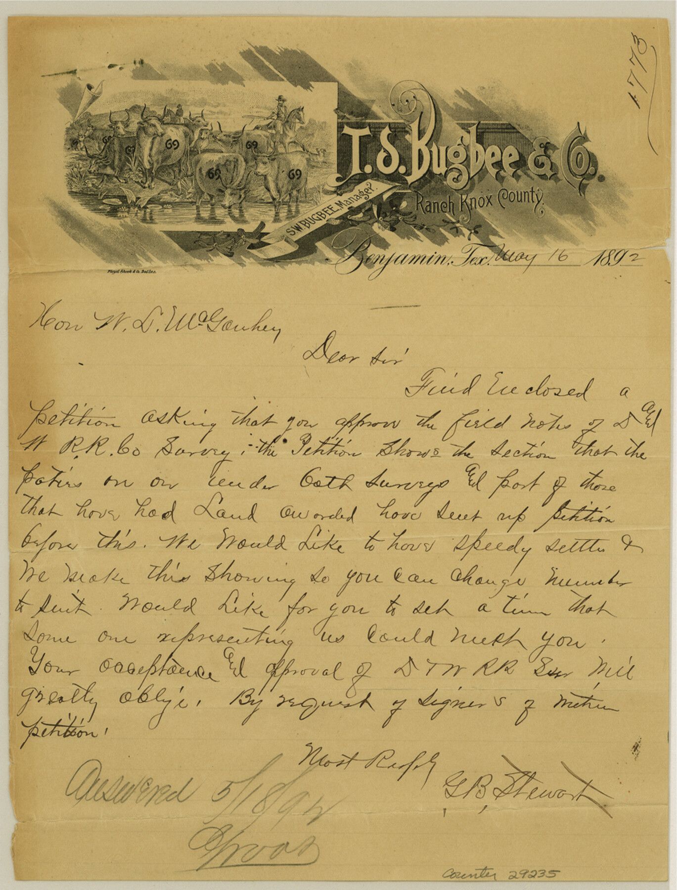
Knox County Sketch File 14
[Petition for a resurvey for J.A. Russell, et al of sections in Blocks 2 and 45 in the southeast corner of the county ]
-
Map/Doc
29235
-
Collection
General Map Collection
-
Object Dates
5/16/1892 (Creation Date)
5/18/1892 (File Date)
7/6/1892 (Correspondence Date)
-
People and Organizations
G.L. Crumm (Surveyor/Engineer)
J.A. Russell (Surveyor/Engineer)
-
Counties
Knox
-
Subjects
Surveying Sketch File
-
Height x Width
11.1 x 8.5 inches
28.2 x 21.6 cm
-
Medium
paper, manuscript
Part of: General Map Collection
Gaines County Boundary File 3

Print $5.00
- Digital $50.00
Gaines County Boundary File 3
Size 13.9 x 9.1 inches
Map/Doc 53654
[Sketch for Mineral Application 16787 - Pecos River Bed, A. T. Freet]
![65632, [Sketch for Mineral Application 16787 - Pecos River Bed, A. T. Freet], General Map Collection](https://historictexasmaps.com/wmedia_w700/maps/65632-1.tif.jpg)
Print $40.00
- Digital $50.00
[Sketch for Mineral Application 16787 - Pecos River Bed, A. T. Freet]
Size 70.8 x 18.9 inches
Map/Doc 65632
Brewster County Working Sketch 71a

Print $40.00
- Digital $50.00
Brewster County Working Sketch 71a
1962
Size 43.5 x 56.0 inches
Map/Doc 67869
Live Oak County Working Sketch 35

Print $20.00
- Digital $50.00
Live Oak County Working Sketch 35
2003
Size 36.4 x 34.7 inches
Map/Doc 82446
[F. W. & D. C. Ry. Co. Alignment and Right of Way Map, Clay County]
![64729, [F. W. & D. C. Ry. Co. Alignment and Right of Way Map, Clay County], General Map Collection](https://historictexasmaps.com/wmedia_w700/maps/64729-1.tif.jpg)
Print $20.00
- Digital $50.00
[F. W. & D. C. Ry. Co. Alignment and Right of Way Map, Clay County]
1927
Size 18.5 x 11.7 inches
Map/Doc 64729
Greer County Sketch File 7

Print $40.00
- Digital $50.00
Greer County Sketch File 7
Size 12.8 x 17.5 inches
Map/Doc 24526
Map of Eastland County, the portion on the waters of Colorado River, Travis - the balance, Milam Land District

Print $20.00
- Digital $50.00
Map of Eastland County, the portion on the waters of Colorado River, Travis - the balance, Milam Land District
1860
Size 23.8 x 21.5 inches
Map/Doc 3501
Territory served by the Galveston Bay Ports, Tex.

Print $20.00
- Digital $50.00
Territory served by the Galveston Bay Ports, Tex.
Size 17.1 x 16.0 inches
Map/Doc 97165
Gulf of Mexico

Print $20.00
- Digital $50.00
Gulf of Mexico
1900
Size 18.3 x 28.1 inches
Map/Doc 72650
Edwards County Working Sketch 63

Print $20.00
- Digital $50.00
Edwards County Working Sketch 63
1955
Size 32.5 x 46.4 inches
Map/Doc 68939
Texas showing Counties, Cities, Towns, Railroads and Water-courses. Completely indexed, showing locations with latest census population figures.

Print $20.00
- Digital $50.00
Texas showing Counties, Cities, Towns, Railroads and Water-courses. Completely indexed, showing locations with latest census population figures.
1950
Size 32.0 x 28.5 inches
Map/Doc 97097
Motley County Sketch File 6 (S)

Print $22.00
- Digital $50.00
Motley County Sketch File 6 (S)
Size 12.9 x 13.8 inches
Map/Doc 32145
You may also like
Harris County Boundary File 39 (22)

Print $40.00
- Digital $50.00
Harris County Boundary File 39 (22)
Size 12.6 x 16.1 inches
Map/Doc 54368
Map of the Texas & Pacific Railway and connections

Print $20.00
- Digital $50.00
Map of the Texas & Pacific Railway and connections
1892
Size 22.5 x 31.9 inches
Map/Doc 95761
Kimble County Rolled Sketch 19

Print $20.00
- Digital $50.00
Kimble County Rolled Sketch 19
Size 38.8 x 33.6 inches
Map/Doc 9339
Dallas County Sketch File 20

Print $4.00
- Digital $50.00
Dallas County Sketch File 20
Size 12.2 x 7.8 inches
Map/Doc 20441
Flight Mission No. CLL-3N, Frame 10, Willacy County

Print $20.00
- Digital $50.00
Flight Mission No. CLL-3N, Frame 10, Willacy County
1954
Size 18.5 x 22.2 inches
Map/Doc 87076
James Subdivision, NE/4 Section 1, Block E, G. C. & S. F. R.R. Co. Cert 3/360, Abstract 46

Print $20.00
- Digital $50.00
James Subdivision, NE/4 Section 1, Block E, G. C. & S. F. R.R. Co. Cert 3/360, Abstract 46
Size 17.8 x 19.4 inches
Map/Doc 92734
San Saba County Working Sketch 13

Print $20.00
- Digital $50.00
San Saba County Working Sketch 13
1995
Size 42.8 x 32.8 inches
Map/Doc 63801
Nueces County Sketch File 39

Print $8.00
- Digital $50.00
Nueces County Sketch File 39
1934
Size 11.0 x 8.5 inches
Map/Doc 32623
Upton County Rolled Sketch 20

Print $40.00
- Digital $50.00
Upton County Rolled Sketch 20
1933
Size 53.0 x 36.8 inches
Map/Doc 10041
[Sketch for Mineral Application 13436 - Cut-off Bayou]
![65675, [Sketch for Mineral Application 13436 - Cut-off Bayou], General Map Collection](https://historictexasmaps.com/wmedia_w700/maps/65675-1.tif.jpg)
Print $20.00
- Digital $50.00
[Sketch for Mineral Application 13436 - Cut-off Bayou]
1928
Size 21.3 x 44.3 inches
Map/Doc 65675
Burnet County Sketch File 18

Print $4.00
- Digital $50.00
Burnet County Sketch File 18
1873
Size 8.3 x 6.5 inches
Map/Doc 16708
Lamar County Boundary File 56

Print $60.00
- Digital $50.00
Lamar County Boundary File 56
Size 8.7 x 6.4 inches
Map/Doc 56000