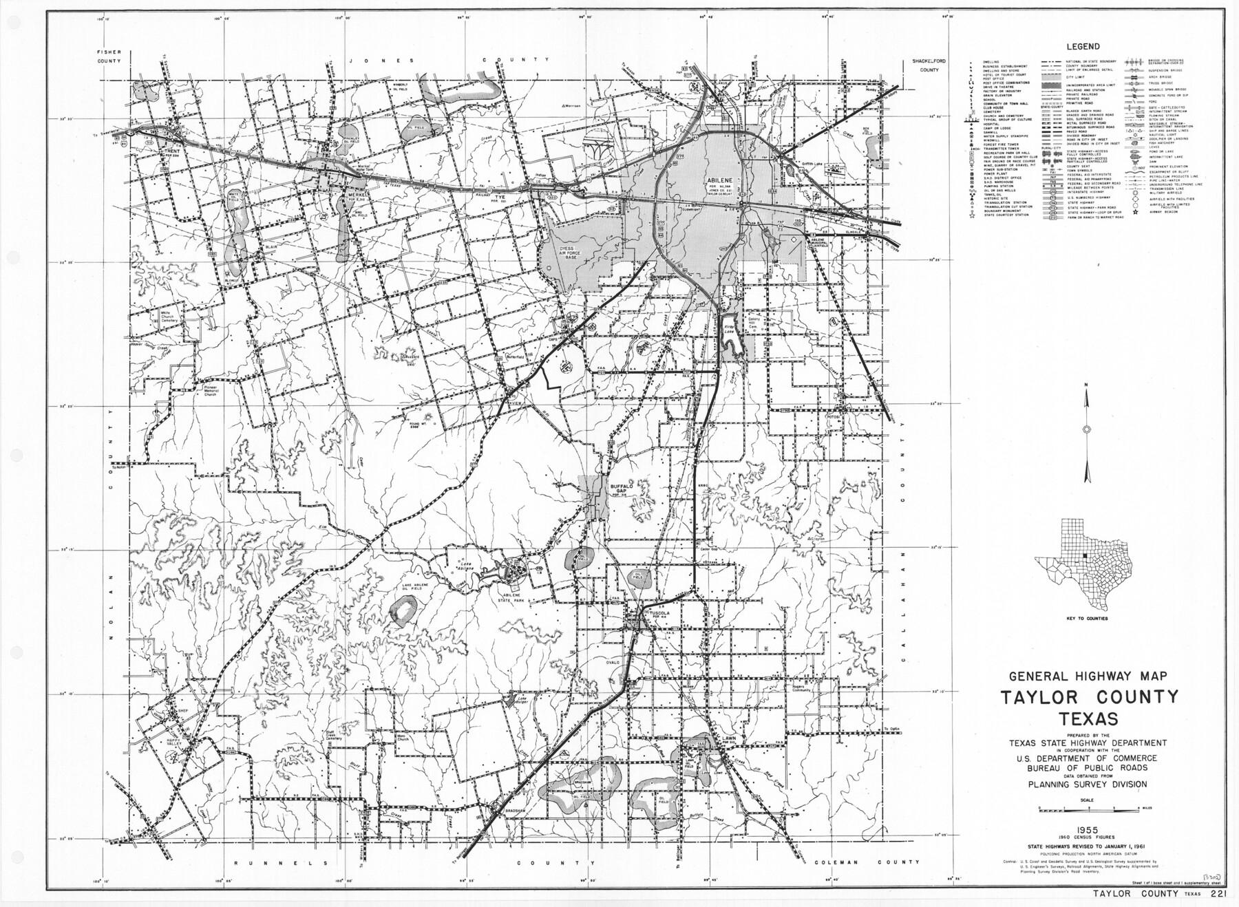
General Highway Map, Taylor County, Texas
-
Map/Doc
79672
-
Collection
Texas State Library and Archives
-
Object Dates
1961 (Creation Date)
-
People and Organizations
Texas State Highway Department (Publisher)
-
Counties
Taylor
-
Subjects
County
-
Height x Width
18.2 x 24.8 inches
46.2 x 63.0 cm
-
Comments
Prints available courtesy of the Texas State Library and Archives.
More info can be found here: TSLAC Map 05302
Part of: Texas State Library and Archives
General Highway Map, Wharton County, Texas

Print $20.00
General Highway Map, Wharton County, Texas
1940
Size 18.5 x 24.9 inches
Map/Doc 79274
General Highway Map, Smith County, Texas

Print $20.00
General Highway Map, Smith County, Texas
1961
Size 25.1 x 18.3 inches
Map/Doc 79654
General Highway Map, Tom Green County, Texas

Print $20.00
General Highway Map, Tom Green County, Texas
1961
Size 18.4 x 25.0 inches
Map/Doc 79678
General Highway Map. Detail of Cities and Towns in Dallas County, Texas [Dallas and vicinity]
![79432, General Highway Map. Detail of Cities and Towns in Dallas County, Texas [Dallas and vicinity], Texas State Library and Archives](https://historictexasmaps.com/wmedia_w700/maps/79432.tif.jpg)
Print $20.00
General Highway Map. Detail of Cities and Towns in Dallas County, Texas [Dallas and vicinity]
1961
Size 18.1 x 24.7 inches
Map/Doc 79432
General Highway Map, San Augustine County, Texas

Print $20.00
General Highway Map, San Augustine County, Texas
1940
Size 24.8 x 18.3 inches
Map/Doc 79235
Plat of Corpus Christi

Print $20.00
Plat of Corpus Christi
1850
Size 18.0 x 27.2 inches
Map/Doc 76269
General Highway Map, Kinney County, Uvalde County, Texas

Print $20.00
General Highway Map, Kinney County, Uvalde County, Texas
1940
Size 18.4 x 24.8 inches
Map/Doc 79162
General Highway Map, Brewster County, Texas

Print $20.00
General Highway Map, Brewster County, Texas
1940
Size 18.5 x 25.2 inches
Map/Doc 79027
Greater Fort Worth New City Map

Print $20.00
Greater Fort Worth New City Map
1925
Size 33.5 x 22.6 inches
Map/Doc 76286
General Highway Map, Brazoria County, Texas

Print $20.00
General Highway Map, Brazoria County, Texas
1939
Size 18.4 x 24.9 inches
Map/Doc 79025
General Highway Map, Guadalupe County, Texas

Print $20.00
General Highway Map, Guadalupe County, Texas
1940
Size 18.6 x 25.1 inches
Map/Doc 79107
General Highway Map, Cottle County, Texas

Print $20.00
General Highway Map, Cottle County, Texas
1940
Size 18.3 x 25.2 inches
Map/Doc 79060
You may also like
Crockett County Rolled Sketch 60

Print $20.00
- Digital $50.00
Crockett County Rolled Sketch 60
Size 18.7 x 18.9 inches
Map/Doc 5603
Fisher County Rolled Sketch 4

Print $20.00
- Digital $50.00
Fisher County Rolled Sketch 4
Size 32.4 x 37.5 inches
Map/Doc 8888
Liberty County Working Sketch Graphic Index - west part

Print $20.00
- Digital $50.00
Liberty County Working Sketch Graphic Index - west part
1977
Size 45.7 x 34.5 inches
Map/Doc 76619
Coke County Working Sketch 21

Print $20.00
- Digital $50.00
Coke County Working Sketch 21
1949
Size 22.9 x 29.4 inches
Map/Doc 68058
Rusk County Working Sketch 35

Print $20.00
- Digital $50.00
Rusk County Working Sketch 35
2005
Size 28.7 x 42.0 inches
Map/Doc 83584
Edwards County Sketch File 6

Print $20.00
- Digital $50.00
Edwards County Sketch File 6
1880
Size 11.7 x 19.6 inches
Map/Doc 11419
Panola County Rolled Sketch 6

Print $40.00
- Digital $50.00
Panola County Rolled Sketch 6
1956
Size 26.0 x 55.7 inches
Map/Doc 9679
Flight Mission No. CGI-3N, Frame 52, Cameron County

Print $20.00
- Digital $50.00
Flight Mission No. CGI-3N, Frame 52, Cameron County
1954
Size 18.7 x 22.2 inches
Map/Doc 84558
Neches River, Watershed of the Neches River

Print $6.00
- Digital $50.00
Neches River, Watershed of the Neches River
1925
Size 34.6 x 28.3 inches
Map/Doc 65085
Flight Mission No. BQR-20K, Frame 8, Brazoria County

Print $20.00
- Digital $50.00
Flight Mission No. BQR-20K, Frame 8, Brazoria County
1952
Size 18.6 x 22.3 inches
Map/Doc 84110
Goliad County Working Sketch 20

Print $20.00
- Digital $50.00
Goliad County Working Sketch 20
1955
Size 31.4 x 22.8 inches
Map/Doc 63210
Lands of the Eastern Mediterranean

Lands of the Eastern Mediterranean
1959
Size 25.5 x 19.5 inches
Map/Doc 92383