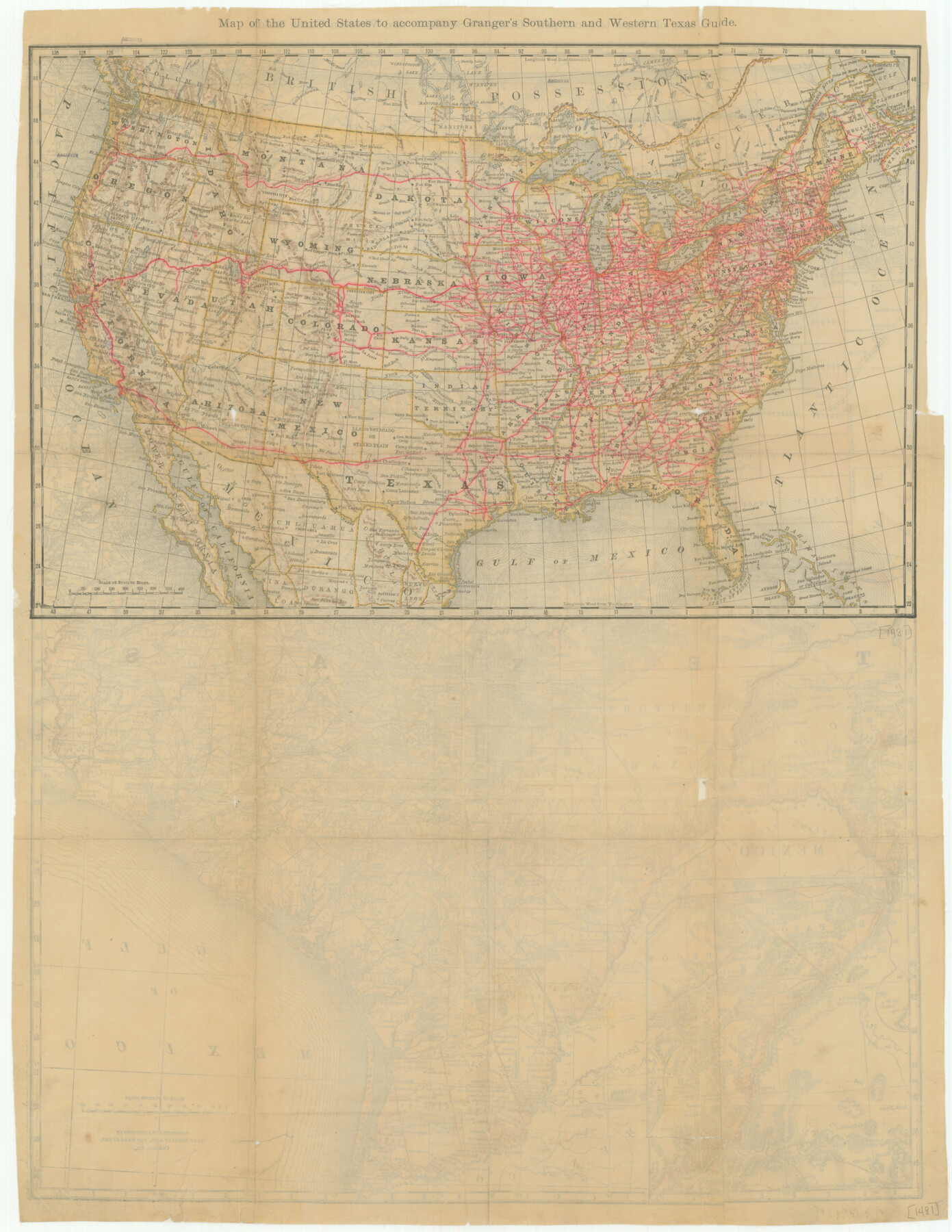
Map of the United States to accompany Granger's Southern and Western Texas Guide
-
Map/Doc
76236
-
Collection
Texas State Library and Archives
-
Object Dates
1878 (Creation Date)
-
People and Organizations
Rand McNally and Company (Publisher)
Rand McNally and Company (Printer)
-
Subjects
United States
-
Height x Width
26.4 x 20.4 inches
67.1 x 51.8 cm
-
Comments
Prints available courtesy of the Texas State Library and Archives.
More info can be found here: TSLAC Map 01481
Part of: Texas State Library and Archives
Preliminary Chart of the Northwestern Part of the Gulf of Mexico

Print $20.00
Preliminary Chart of the Northwestern Part of the Gulf of Mexico
1855
Size 32.3 x 41.6 inches
Map/Doc 79334
General Highway Map, Victoria County, Texas

Print $20.00
General Highway Map, Victoria County, Texas
1961
Size 25.0 x 18.3 inches
Map/Doc 79697
General Highway Map, Irion County, Texas

Print $20.00
General Highway Map, Irion County, Texas
1940
Size 18.3 x 24.8 inches
Map/Doc 79138

General Highway Map, Panola County, Texas

Print $20.00
General Highway Map, Panola County, Texas
1940
Size 18.2 x 24.6 inches
Map/Doc 79214
General Highway Map. Detail of Cities and Towns in McLennan County, Texas

Print $20.00
General Highway Map. Detail of Cities and Towns in McLennan County, Texas
1961
Size 18.2 x 24.6 inches
Map/Doc 79591
General Highway Map, Baylor County, Texas

Print $20.00
General Highway Map, Baylor County, Texas
1940
Size 18.3 x 25.1 inches
Map/Doc 79013
Stremme General Land Office Drawings, side view

Print $20.00
Stremme General Land Office Drawings, side view
Size 27.0 x 21.8 inches
Map/Doc 79739
General Highway Map, Bowie County, Texas

Print $20.00
General Highway Map, Bowie County, Texas
1940
Size 18.4 x 24.9 inches
Map/Doc 79023
General Highway Map. Detail of Cities and Towns in Williamson County, Texas [Round Rock, Taylor, Georgetown]
![79714, General Highway Map. Detail of Cities and Towns in Williamson County, Texas [Round Rock, Taylor, Georgetown], Texas State Library and Archives](https://historictexasmaps.com/wmedia_w700/maps/79714.tif.jpg)
Print $20.00
General Highway Map. Detail of Cities and Towns in Williamson County, Texas [Round Rock, Taylor, Georgetown]
1961
Size 18.2 x 24.8 inches
Map/Doc 79714
General Highway Map, Medina County, Texas

Print $20.00
General Highway Map, Medina County, Texas
1940
Size 18.3 x 24.6 inches
Map/Doc 79195
Oil and Gas Fields in the State of Texas

Print $40.00
Oil and Gas Fields in the State of Texas
1927
Size 58.2 x 38.1 inches
Map/Doc 76303
You may also like
Outer Continental Shelf Leasing Maps (Texas Offshore Operations)

Print $20.00
- Digital $50.00
Outer Continental Shelf Leasing Maps (Texas Offshore Operations)
Size 12.7 x 15.2 inches
Map/Doc 76169
Current Miscellaneous File 111

Print $8.00
- Digital $50.00
Current Miscellaneous File 111
1996
Size 11.3 x 8.7 inches
Map/Doc 74714

General Highway Map, San Jacinto County, Texas

Print $20.00
General Highway Map, San Jacinto County, Texas
1940
Size 24.9 x 18.4 inches
Map/Doc 79236
Flight Mission No. BRA-3M, Frame 127, Jefferson County

Print $20.00
- Digital $50.00
Flight Mission No. BRA-3M, Frame 127, Jefferson County
1953
Size 18.5 x 21.6 inches
Map/Doc 85401
Polk County Sketch File 27

Print $8.00
- Digital $50.00
Polk County Sketch File 27
1891
Size 14.1 x 8.7 inches
Map/Doc 34194
Shackelford County Working Sketch 7

Print $20.00
- Digital $50.00
Shackelford County Working Sketch 7
1963
Size 22.4 x 23.3 inches
Map/Doc 63847
Padre Island National Seashore

Print $4.00
- Digital $50.00
Padre Island National Seashore
Size 15.9 x 22.3 inches
Map/Doc 60539
Intracoastal Waterway in Texas - Corpus Christi to Point Isabel including Arroyo Colorado to Mo. Pac. R.R. Bridge Near Harlingen

Print $20.00
- Digital $50.00
Intracoastal Waterway in Texas - Corpus Christi to Point Isabel including Arroyo Colorado to Mo. Pac. R.R. Bridge Near Harlingen
1933
Size 28.0 x 40.7 inches
Map/Doc 61848
Oklahoma and Indian Territory Along the Frisco

Oklahoma and Indian Territory Along the Frisco
1905
Map/Doc 96771
Map of Main Line Houston & Tex. Centr. Railway from Dallas to Red River City

Print $40.00
- Digital $50.00
Map of Main Line Houston & Tex. Centr. Railway from Dallas to Red River City
Size 37.1 x 84.9 inches
Map/Doc 64089
Sterling County Sketch File 15

Print $8.00
- Digital $50.00
Sterling County Sketch File 15
1935
Size 11.1 x 8.8 inches
Map/Doc 37150