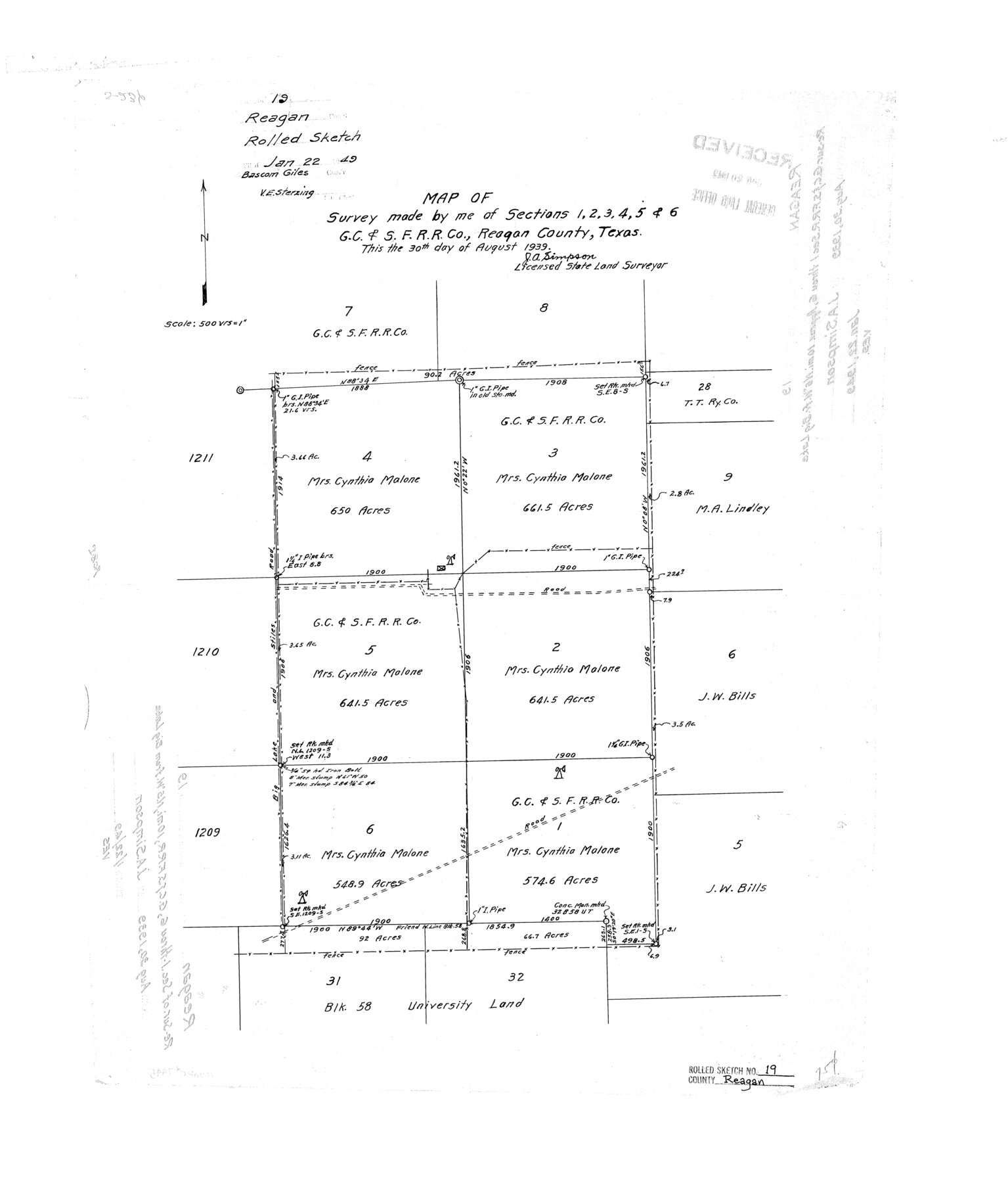
Reagan County Rolled Sketch 19
Map of survey made by me of sections 1, 2, 3, 4, 5, & 6, G. C. & S. F. R.R. Co., Reagan County, Texas
-
Map/Doc
7445
-
Collection
General Map Collection
-
Object Dates
1939/8/30 (Creation Date)
1949/1/22 (File Date)
-
People and Organizations
J.A. Simpson (Surveyor/Engineer)
-
Counties
Reagan
-
Subjects
Surveying Rolled Sketch
-
Height x Width
24.0 x 20.5 inches
61.0 x 52.1 cm
-
Scale
1" = 500 varas
Part of: General Map Collection

Castro County Sketch File 13

Print $4.00
- Digital $50.00
Castro County Sketch File 13
1962
Size 14.1 x 8.6 inches
Map/Doc 17509
Hardin County Sketch File 29

Print $4.00
- Digital $50.00
Hardin County Sketch File 29
Size 8.1 x 11.8 inches
Map/Doc 25155
Menard County Boundary File 3a

Print $4.00
- Digital $50.00
Menard County Boundary File 3a
Size 10.6 x 8.1 inches
Map/Doc 57074
Kinney County Working Sketch 37

Print $20.00
- Digital $50.00
Kinney County Working Sketch 37
1971
Size 25.7 x 21.7 inches
Map/Doc 70219
Wharton County Working Sketch 1

Print $20.00
- Digital $50.00
Wharton County Working Sketch 1
Size 23.3 x 21.4 inches
Map/Doc 72465
Aransas County Working Sketch 22

Print $20.00
- Digital $50.00
Aransas County Working Sketch 22
Size 24.3 x 18.2 inches
Map/Doc 67189
Aransas County

Print $20.00
- Digital $50.00
Aransas County
1871
Size 17.2 x 18.3 inches
Map/Doc 3235
Current Miscellaneous File 117

Print $8.00
- Digital $50.00
Current Miscellaneous File 117
2001
Size 11.2 x 8.8 inches
Map/Doc 74823
Mississippi River to Galveston

Print $40.00
- Digital $50.00
Mississippi River to Galveston
1973
Size 37.2 x 51.2 inches
Map/Doc 69946
Tyler County Sketch File 8

Print $4.00
- Digital $50.00
Tyler County Sketch File 8
Size 8.6 x 6.8 inches
Map/Doc 38642
Harris County Working Sketch 127

Print $20.00
- Digital $50.00
Harris County Working Sketch 127
1996
Size 20.7 x 26.0 inches
Map/Doc 66019
You may also like
Galveston County Rolled Sketch 28

Print $347.00
- Digital $50.00
Galveston County Rolled Sketch 28
Size 22.6 x 18.1 inches
Map/Doc 6068
Leon County Rolled Sketch 4

Print $20.00
- Digital $50.00
Leon County Rolled Sketch 4
1947
Size 34.6 x 35.4 inches
Map/Doc 9426
Sabine County Working Sketch 16

Print $20.00
- Digital $50.00
Sabine County Working Sketch 16
1984
Size 26.0 x 29.8 inches
Map/Doc 63687
Right of Way and Track Map Houston & Texas Central R.R. operated by the T. and N. O. R.R. Co., Fort Worth Branch

Print $40.00
- Digital $50.00
Right of Way and Track Map Houston & Texas Central R.R. operated by the T. and N. O. R.R. Co., Fort Worth Branch
1918
Size 31.1 x 57.4 inches
Map/Doc 64540
Moxley-McWhorter Irrigated Farm

Print $20.00
- Digital $50.00
Moxley-McWhorter Irrigated Farm
1946
Size 27.5 x 15.8 inches
Map/Doc 92338
Hood County Working Sketch 14

Print $20.00
- Digital $50.00
Hood County Working Sketch 14
1980
Size 24.1 x 24.6 inches
Map/Doc 66208
Edwards County Working Sketch 89

Print $40.00
- Digital $50.00
Edwards County Working Sketch 89
1966
Size 49.7 x 28.8 inches
Map/Doc 68965
Duval County Boundary File 3c

Print $12.00
- Digital $50.00
Duval County Boundary File 3c
Size 11.7 x 8.4 inches
Map/Doc 52732
Hays County Rolled Sketch 31

Print $20.00
- Digital $50.00
Hays County Rolled Sketch 31
2001
Size 24.0 x 34.7 inches
Map/Doc 76421
Pecos County Sketch File 114

Print $18.00
- Digital $50.00
Pecos County Sketch File 114
1912
Size 13.3 x 8.9 inches
Map/Doc 34074
Presidio County Working Sketch Graphic Index, West Part, Sheet 2 (Sketches 75 to Most Recent)

Print $20.00
- Digital $50.00
Presidio County Working Sketch Graphic Index, West Part, Sheet 2 (Sketches 75 to Most Recent)
1974
Size 40.7 x 31.9 inches
Map/Doc 76673
Jackson County Working Sketch 8

Print $20.00
- Digital $50.00
Jackson County Working Sketch 8
1980
Size 30.4 x 29.0 inches
Map/Doc 66456