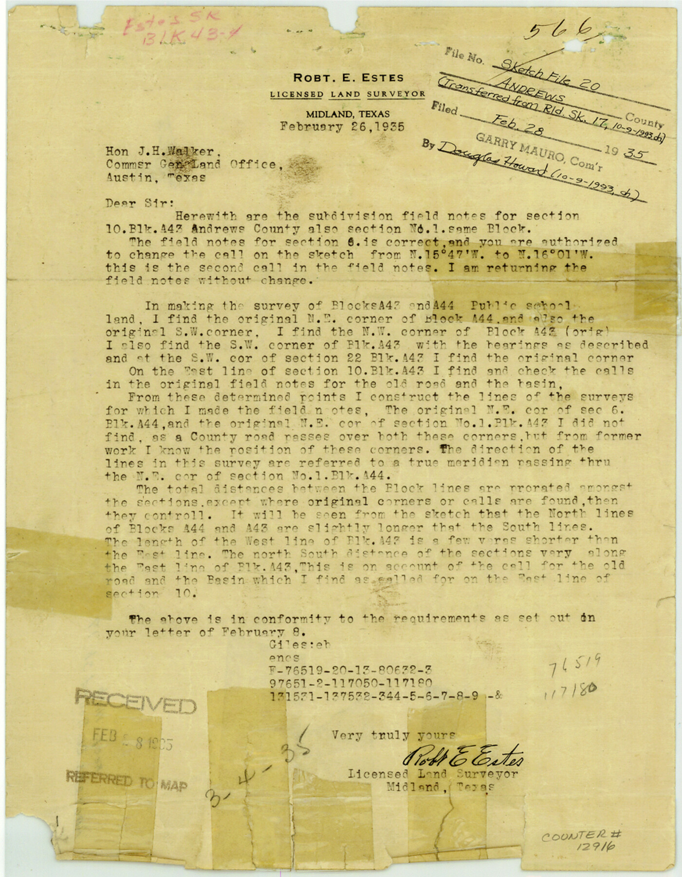
Andrews County Sketch File 20
[Report and sketch regarding sections in Block A-43]
Andrews County Rolled Sketch 17
-
Map/Doc
12916
-
Collection
General Map Collection
-
Object Dates
1935/2/26 (Correspondence Date)
1935/2/28 (File Date)
-
People and Organizations
Robt. E. Estes (Surveyor/Engineer)
-
Counties
Andrews
-
Subjects
Surveying Sketch File
-
Height x Width
11.2 x 8.7 inches
28.4 x 22.1 cm
-
Medium
multi-page, multi-format
-
Comments
See Andrews County Rolled Sketch 17 (8393) for sketch
Related maps
Andrews County Rolled Sketch 17

Print $40.00
- Digital $50.00
Andrews County Rolled Sketch 17
1934
Size 30.9 x 48.9 inches
Map/Doc 8393
Part of: General Map Collection
Palo Pinto County

Print $20.00
- Digital $50.00
Palo Pinto County
1898
Size 44.8 x 38.0 inches
Map/Doc 66964
Maverick County Working Sketch 20

Print $4.00
- Digital $50.00
Maverick County Working Sketch 20
1977
Size 26.1 x 22.0 inches
Map/Doc 70912
Hill County Sketch file 28

Print $33.00
- Digital $50.00
Hill County Sketch file 28
1987
Size 11.3 x 8.9 inches
Map/Doc 26530

Motley County Sketch File 30 (S)

Print $40.00
- Digital $50.00
Motley County Sketch File 30 (S)
1905
Size 16.1 x 17.1 inches
Map/Doc 42147
Gulf Coast of the United States, Key West to Rio Grande

Print $20.00
- Digital $50.00
Gulf Coast of the United States, Key West to Rio Grande
1863
Size 27.5 x 18.2 inches
Map/Doc 72665
Map of Texas in 1836

Print $20.00
- Digital $50.00
Map of Texas in 1836
1936
Size 32.1 x 24.4 inches
Map/Doc 2110
Clay County Working Sketch 11
Print $20.00
- Digital $50.00
Clay County Working Sketch 11
1941
Size 27.7 x 27.1 inches
Map/Doc 68034
Lynn County Rolled Sketch 12

Print $20.00
- Digital $50.00
Lynn County Rolled Sketch 12
1956
Size 35.0 x 24.5 inches
Map/Doc 6648
Flight Mission No. CGI-3N, Frame 132, Cameron County

Print $20.00
- Digital $50.00
Flight Mission No. CGI-3N, Frame 132, Cameron County
1954
Size 18.4 x 22.2 inches
Map/Doc 84605
Marion County Working Sketch Graphic Index, Sheet 1 (Sketches 1 to 26)

Print $20.00
- Digital $50.00
Marion County Working Sketch Graphic Index, Sheet 1 (Sketches 1 to 26)
1943
Size 26.8 x 45.1 inches
Map/Doc 76629
Nueces County Rolled Sketch 36

Print $199.00
- Digital $50.00
Nueces County Rolled Sketch 36
Size 10.7 x 15.2 inches
Map/Doc 47617
You may also like
Comanche County Working Sketch 17

Print $20.00
- Digital $50.00
Comanche County Working Sketch 17
1972
Size 39.5 x 37.4 inches
Map/Doc 68151
Brewster County Rolled Sketch 14

Print $20.00
- Digital $50.00
Brewster County Rolled Sketch 14
1889
Size 31.5 x 27.3 inches
Map/Doc 8469
[Township 3 North, Blocks 31 and 32]
![91213, [Township 3 North, Blocks 31 and 32], Twichell Survey Records](https://historictexasmaps.com/wmedia_w700/maps/91213-1.tif.jpg)
Print $3.00
- Digital $50.00
[Township 3 North, Blocks 31 and 32]
Size 12.5 x 10.8 inches
Map/Doc 91213
Map and Profile No. 1 from the Red River to the Rio Grande; from Explorations and surveys made under the direction of the Hon. Jeffeson Davis, Secretary of War

Print $40.00
- Digital $50.00
Map and Profile No. 1 from the Red River to the Rio Grande; from Explorations and surveys made under the direction of the Hon. Jeffeson Davis, Secretary of War
1856
Size 30.5 x 57.0 inches
Map/Doc 4330

Harris County Working Sketch 18

Print $20.00
- Digital $50.00
Harris County Working Sketch 18
1919
Size 12.1 x 14.8 inches
Map/Doc 65910
The Republic County of Nacogdoches. December 6, 1841

Print $20.00
The Republic County of Nacogdoches. December 6, 1841
2020
Size 15.9 x 21.8 inches
Map/Doc 96246

Swisher County Boundary File 2

Print $106.00
- Digital $50.00
Swisher County Boundary File 2
Size 14.3 x 9.0 inches
Map/Doc 59093
Refugio County Boundary File 2a

Print $8.00
- Digital $50.00
Refugio County Boundary File 2a
Size 14.5 x 9.1 inches
Map/Doc 58240
Laguna Madre, Texas from Triangulation Station Singer to Latitude 26° 20'

Print $40.00
- Digital $50.00
Laguna Madre, Texas from Triangulation Station Singer to Latitude 26° 20'
1880
Size 31.9 x 53.4 inches
Map/Doc 73493
Uvalde County Rolled Sketch 10

Print $20.00
- Digital $50.00
Uvalde County Rolled Sketch 10
Size 23.5 x 16.1 inches
Map/Doc 8095