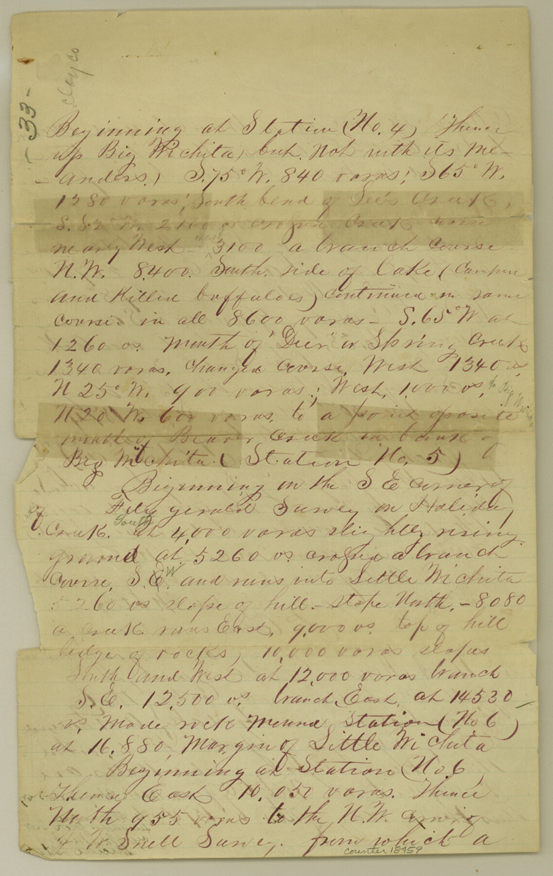
Clay County Sketch File 33
[Explanation of surveys on Big Wichita]
-
Map/Doc
18459
-
Collection
General Map Collection
-
Object Dates
1874 (Survey Date)
-
People and Organizations
Dennis Corwin (Surveyor/Engineer)
-
Counties
Clay
-
Subjects
Surveying Sketch File
-
Height x Width
12.0 x 7.6 inches
30.5 x 19.3 cm
-
Medium
paper, manuscript
-
Features
Big Wichita River
Lee's Creek
Deer Creek
Spring Creek
Little Wichita River
Post Oak Creek
Part of: General Map Collection
Young County Working Sketch 17

Print $20.00
- Digital $50.00
Young County Working Sketch 17
1958
Size 20.7 x 28.6 inches
Map/Doc 62040
Nueces County Aerial Photograph Index Sheet 2

Print $20.00
- Digital $50.00
Nueces County Aerial Photograph Index Sheet 2
1956
Size 19.5 x 23.3 inches
Map/Doc 83737
Red River County Rolled Sketch 7A

Print $20.00
- Digital $50.00
Red River County Rolled Sketch 7A
Size 28.3 x 33.1 inches
Map/Doc 7472
Martin County Sketch File 5

Print $4.00
- Digital $50.00
Martin County Sketch File 5
1913
Size 11.4 x 8.7 inches
Map/Doc 30640
Upton County Rolled Sketch 18

Print $40.00
- Digital $50.00
Upton County Rolled Sketch 18
1933
Size 38.3 x 55.5 inches
Map/Doc 10039

Pecos County Rolled Sketch 118

Print $20.00
- Digital $50.00
Pecos County Rolled Sketch 118
1941
Size 42.0 x 30.3 inches
Map/Doc 7260
Orange County Sketch File 17a

Print $4.00
- Digital $50.00
Orange County Sketch File 17a
Size 9.9 x 8.3 inches
Map/Doc 33342
Midland County Working Sketch 32

Print $40.00
- Digital $50.00
Midland County Working Sketch 32
1971
Size 51.3 x 35.5 inches
Map/Doc 71013
Limestone County Sketch File 5

Print $44.00
- Digital $50.00
Limestone County Sketch File 5
1848
Size 9.7 x 7.6 inches
Map/Doc 30160
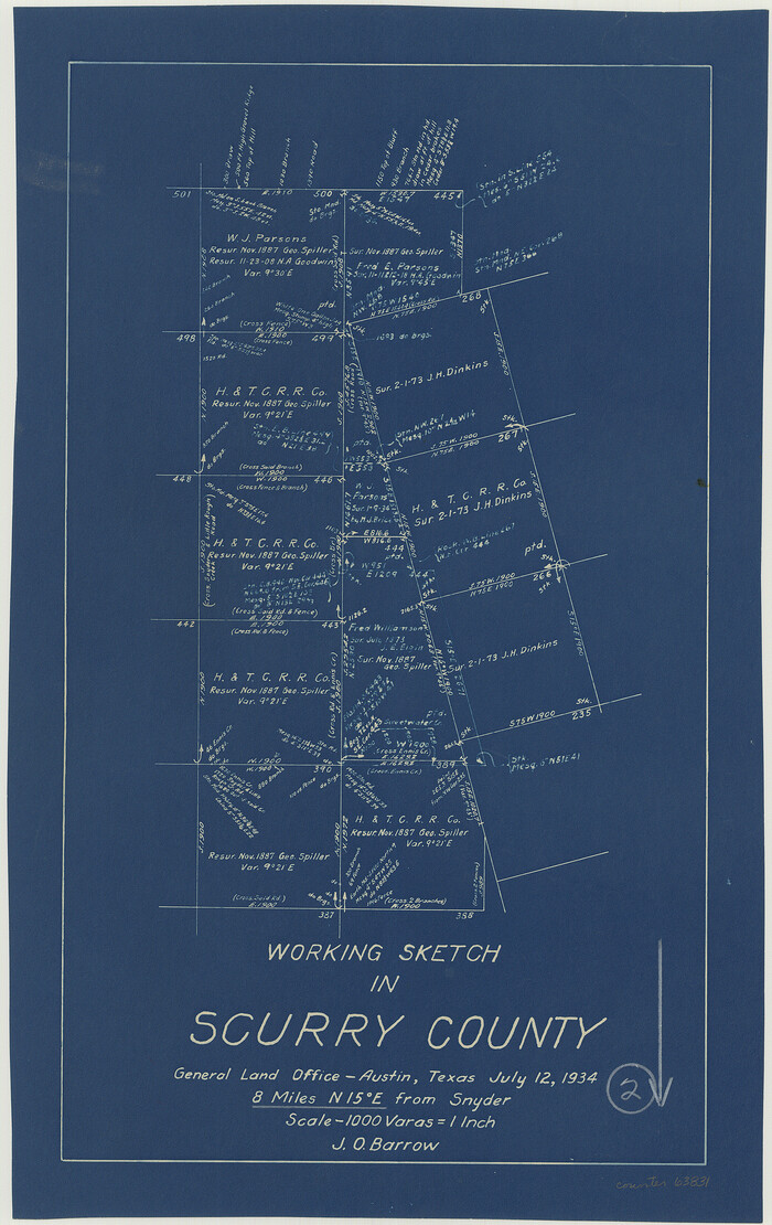
Scurry County Working Sketch 2
Print $3.00
- Digital $50.00
Scurry County Working Sketch 2
1934
Size 16.2 x 10.2 inches
Map/Doc 63831
Webb County Working Sketch 34

Print $20.00
- Digital $50.00
Webb County Working Sketch 34
1938
Size 23.8 x 24.3 inches
Map/Doc 72399
You may also like
Garza County Rolled Sketch 14

Print $41.00
- Digital $50.00
Garza County Rolled Sketch 14
1913
Size 10.0 x 15.2 inches
Map/Doc 45234
St. Marks to Galveston - Sheet II

Print $20.00
- Digital $50.00
St. Marks to Galveston - Sheet II
1846
Size 26.5 x 40.5 inches
Map/Doc 97397
Frio County Sketch File 2a

Print $6.00
- Digital $50.00
Frio County Sketch File 2a
1861
Size 16.0 x 11.0 inches
Map/Doc 23107
Upton County Sketch File 20

Print $40.00
- Digital $50.00
Upton County Sketch File 20
1927
Size 18.5 x 29.2 inches
Map/Doc 12516
Scurry County Rolled Sketch 6

Print $20.00
- Digital $50.00
Scurry County Rolled Sketch 6
1944
Size 29.0 x 28.8 inches
Map/Doc 7766
Galveston County NRC Article 33.136 Sketch 33

Print $20.00
- Digital $50.00
Galveston County NRC Article 33.136 Sketch 33
2003
Size 42.5 x 30.9 inches
Map/Doc 83285
Cameron County Rolled Sketch 20E

Print $20.00
- Digital $50.00
Cameron County Rolled Sketch 20E
Size 13.0 x 12.5 inches
Map/Doc 5478
Flight Mission No. BRA-8M, Frame 88, Jefferson County

Print $20.00
- Digital $50.00
Flight Mission No. BRA-8M, Frame 88, Jefferson County
1953
Size 18.6 x 22.3 inches
Map/Doc 85608
Winkler County

Print $20.00
- Digital $50.00
Winkler County
1932
Size 40.3 x 40.1 inches
Map/Doc 77462
Pendleton-Baxter Addition to Shamrock, Texas

Print $20.00
- Digital $50.00
Pendleton-Baxter Addition to Shamrock, Texas
Size 13.0 x 14.0 inches
Map/Doc 92116
Flight Mission No. DIX-8P, Frame 58, Aransas County

Print $20.00
- Digital $50.00
Flight Mission No. DIX-8P, Frame 58, Aransas County
1956
Size 18.6 x 22.5 inches
Map/Doc 83889
McLennan County Sketch File 19

Print $18.00
- Digital $50.00
McLennan County Sketch File 19
1889
Size 12.8 x 7.9 inches
Map/Doc 31284