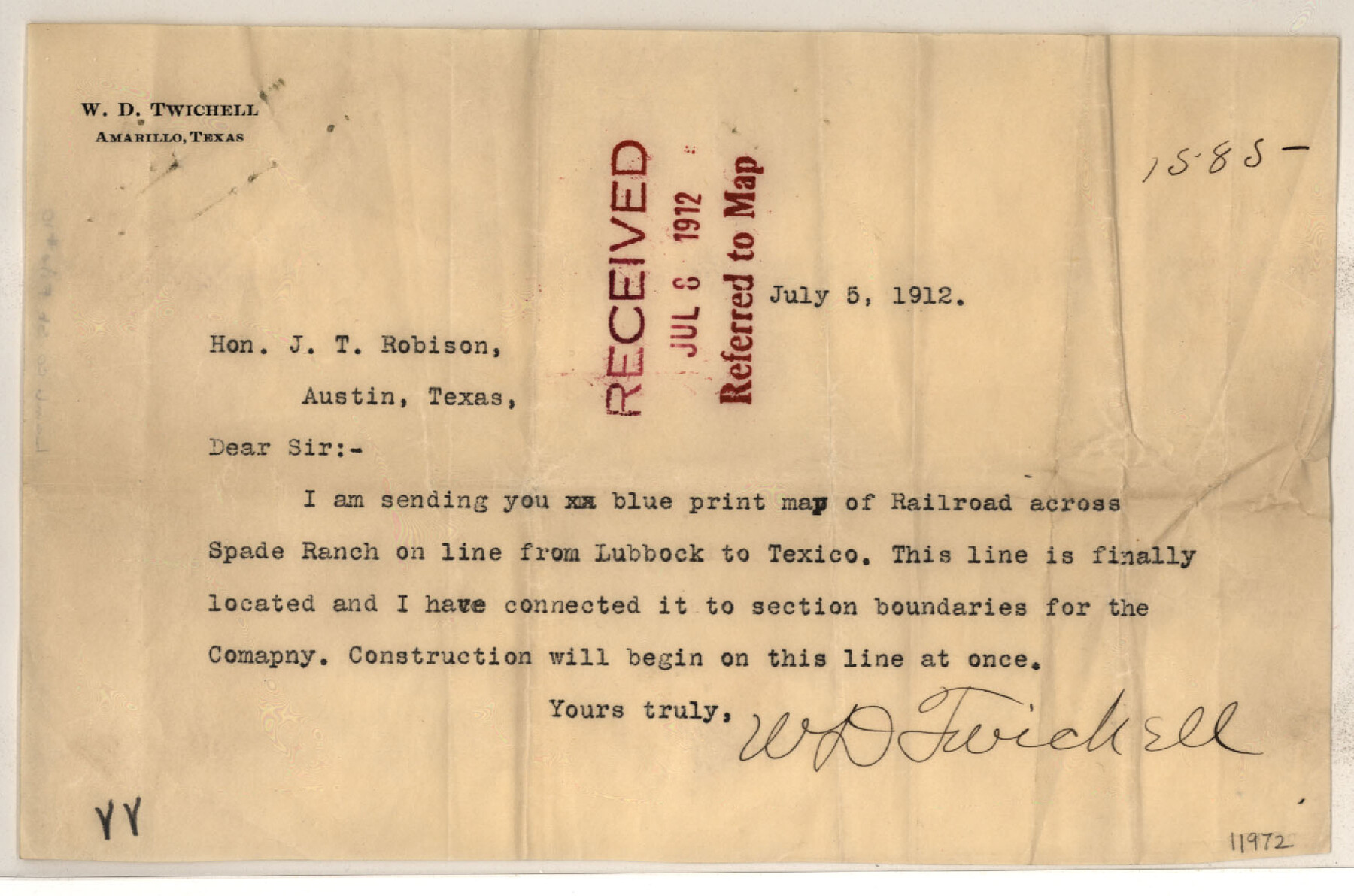
Lamb County Sketch File 10
[Sketch connecting section boundaries to railroad line across Spade Ranch in southeast corner of the county]
-
Map/Doc
11972
-
Collection
General Map Collection
-
Object Dates
7/5/1912 (Creation Date)
7/8/1912 (File Date)
-
People and Organizations
W.D. Twichell (Surveyor/Engineer)
-
Counties
Lamb Hockley Lubbock Hale
-
Subjects
Surveying Sketch File
-
Height x Width
20.0 x 31.2 inches
50.8 x 79.3 cm
-
Medium
multi-page, multi-format
-
Features
Spade Ranch
Lubbock
Texico
Yellow House Creek
P&NT
Part of: General Map Collection
McCulloch County Boundary File 1

Print $40.00
- Digital $50.00
McCulloch County Boundary File 1
Size 9.2 x 33.6 inches
Map/Doc 56906
Sketch H No. V Showing the observed and computed Tidal Curves at Cat Island, Mississippi Sound in 1848 & 1849

Print $20.00
- Digital $50.00
Sketch H No. V Showing the observed and computed Tidal Curves at Cat Island, Mississippi Sound in 1848 & 1849
1852
Size 12.3 x 19.5 inches
Map/Doc 97226
Medina County

Print $40.00
- Digital $50.00
Medina County
1915
Size 50.1 x 42.1 inches
Map/Doc 66924
Tyler County Sketch File 19

Print $4.00
- Digital $50.00
Tyler County Sketch File 19
Size 3.5 x 6.1 inches
Map/Doc 38670
Fractional Township No. 8 South Range No. 8 East of the Indian Meridian, Indian Territory

Print $20.00
- Digital $50.00
Fractional Township No. 8 South Range No. 8 East of the Indian Meridian, Indian Territory
1898
Size 19.2 x 24.2 inches
Map/Doc 75214
Trinity River, Eagle Ford Sheet/Trinity and Elm Fork of Trinity River

Print $20.00
- Digital $50.00
Trinity River, Eagle Ford Sheet/Trinity and Elm Fork of Trinity River
1917
Size 29.5 x 23.2 inches
Map/Doc 69685
Edwards County Working Sketch 10

Print $20.00
- Digital $50.00
Edwards County Working Sketch 10
1920
Size 21.9 x 18.3 inches
Map/Doc 68886
Brewster County Sketch File NS-15

Print $40.00
- Digital $50.00
Brewster County Sketch File NS-15
1977
Size 16.7 x 14.4 inches
Map/Doc 16298
Crane County Sketch File 29

Print $6.00
- Digital $50.00
Crane County Sketch File 29
1930
Size 12.8 x 10.4 inches
Map/Doc 19608
Coleman County Sketch File 42

Print $24.00
- Digital $50.00
Coleman County Sketch File 42
1891
Size 5.8 x 8.9 inches
Map/Doc 18763
[T&P Land Reserve, Blocks 33, 34 & 35, Tsps. 2, 3, 4, & 5, Dawson & Martin Counties, Texas

Print $20.00
- Digital $50.00
[T&P Land Reserve, Blocks 33, 34 & 35, Tsps. 2, 3, 4, & 5, Dawson & Martin Counties, Texas
1875
Size 29.6 x 34.9 inches
Map/Doc 2223
La Salle County Working Sketch 42

Print $20.00
- Digital $50.00
La Salle County Working Sketch 42
1976
Size 33.4 x 33.3 inches
Map/Doc 70343
You may also like
Amistad International Reservoir on Rio Grande 94

Print $20.00
- Digital $50.00
Amistad International Reservoir on Rio Grande 94
1950
Size 28.6 x 41.0 inches
Map/Doc 75524
Throckmorton County Rolled Sketch 4

Print $20.00
- Digital $50.00
Throckmorton County Rolled Sketch 4
1993
Size 23.0 x 35.0 inches
Map/Doc 7990
Red River County Sketch File 16

Print $4.00
- Digital $50.00
Red River County Sketch File 16
1866
Size 8.7 x 7.8 inches
Map/Doc 35139
Fort Bend County Sketch File 4a

Print $40.00
- Digital $50.00
Fort Bend County Sketch File 4a
1887
Size 15.8 x 12.3 inches
Map/Doc 22887
Flight Mission No. DCL-7C, Frame 146, Kenedy County

Print $20.00
- Digital $50.00
Flight Mission No. DCL-7C, Frame 146, Kenedy County
1943
Size 18.8 x 22.4 inches
Map/Doc 86103
Atascosa County Working Sketch 39

Print $20.00
- Digital $50.00
Atascosa County Working Sketch 39
2011
Size 43.2 x 34.8 inches
Map/Doc 90068
Flight Mission No. CUG-2P, Frame 21, Kleberg County

Print $20.00
- Digital $50.00
Flight Mission No. CUG-2P, Frame 21, Kleberg County
1956
Size 18.5 x 22.3 inches
Map/Doc 86185
Chambers County Sketch File 55

Print $10.00
- Digital $50.00
Chambers County Sketch File 55
1935
Size 14.3 x 8.6 inches
Map/Doc 18094
Gray County Sketch File 6

Print $20.00
- Digital $50.00
Gray County Sketch File 6
1882
Size 26.3 x 21.4 inches
Map/Doc 11575

Anderson County Sketch File 26

Print $40.00
- Digital $50.00
Anderson County Sketch File 26
1954
Size 22.7 x 17.4 inches
Map/Doc 10805
Fisher County Sketch File 17

Print $6.00
- Digital $50.00
Fisher County Sketch File 17
Size 11.0 x 12.5 inches
Map/Doc 22587