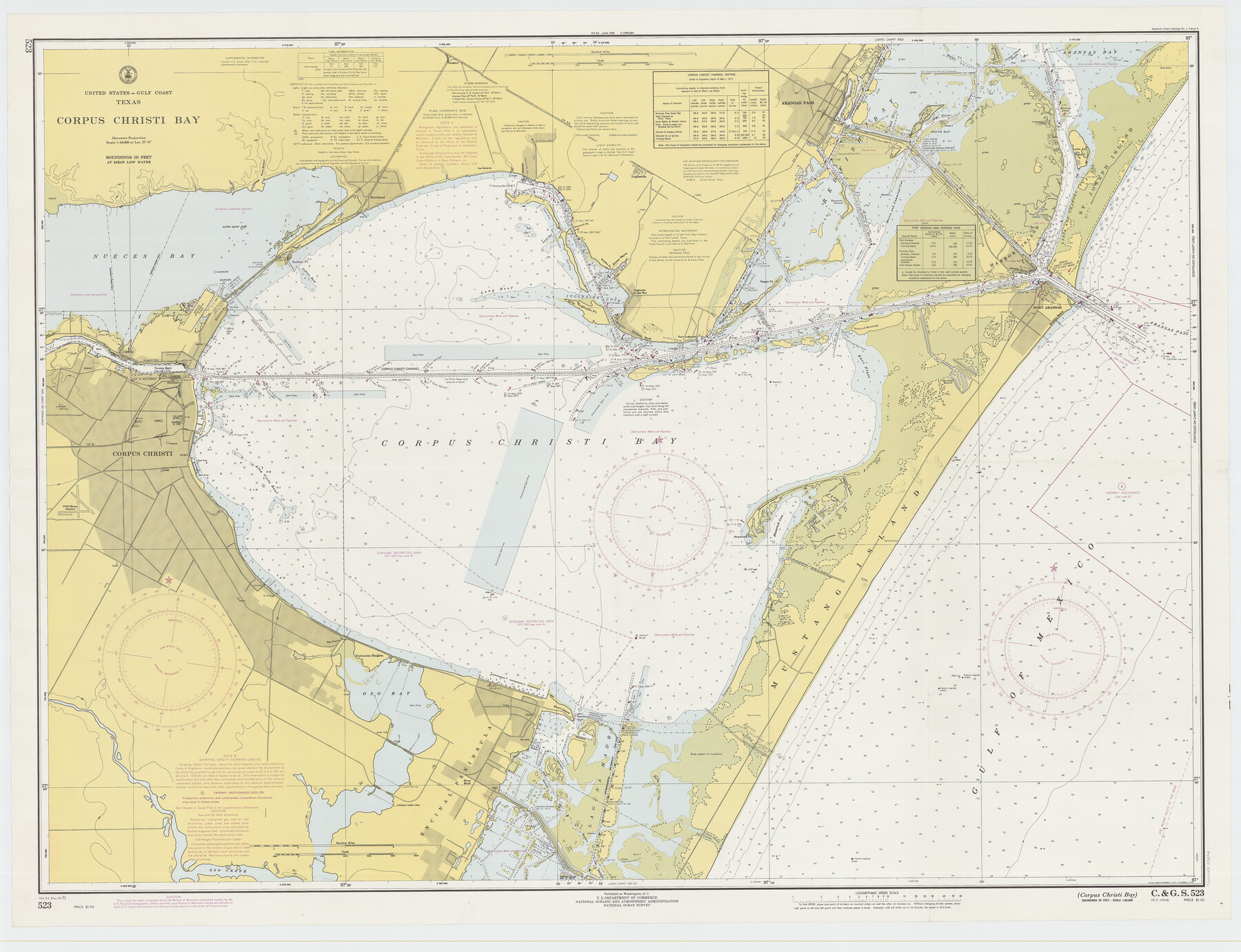
Corpus Christi Bay
-
Map/Doc
73472
-
Collection
General Map Collection
-
Object Dates
1971/5/29 (Creation Date)
-
Counties
Nueces San Patricio
-
Subjects
Nautical Charts
-
Height x Width
36.4 x 47.4 inches
92.5 x 120.4 cm
Part of: General Map Collection
Gaines County Sketch File 1

Print $20.00
- Digital $50.00
Gaines County Sketch File 1
Size 19.1 x 30.7 inches
Map/Doc 11521
Culberson County Working Sketch 26

Print $20.00
- Digital $50.00
Culberson County Working Sketch 26
1951
Size 42.7 x 28.3 inches
Map/Doc 68479
Glasscock County Working Sketch 1

Print $20.00
- Digital $50.00
Glasscock County Working Sketch 1
Size 26.6 x 43.0 inches
Map/Doc 63174
Red River County Working Sketch 33

Print $20.00
- Digital $50.00
Red River County Working Sketch 33
1963
Size 47.0 x 22.2 inches
Map/Doc 72016
La Salle County Sketch File 36

Print $40.00
- Digital $50.00
La Salle County Sketch File 36
1898
Size 12.2 x 12.6 inches
Map/Doc 29589
Morris County Rolled Sketch 2A

Print $20.00
- Digital $50.00
Morris County Rolled Sketch 2A
Size 24.0 x 18.8 inches
Map/Doc 10254
Kendall County

Print $20.00
- Digital $50.00
Kendall County
1946
Size 40.8 x 35.4 inches
Map/Doc 73203
Palo Pinto County Rolled Sketch 2

Print $20.00
- Digital $50.00
Palo Pinto County Rolled Sketch 2
1917
Size 37.5 x 43.8 inches
Map/Doc 9669
Hood County Sketch File 23

Print $20.00
- Digital $50.00
Hood County Sketch File 23
Size 24.5 x 18.6 inches
Map/Doc 11780
Coke County Rolled Sketch 14C

Print $20.00
- Digital $50.00
Coke County Rolled Sketch 14C
Size 25.8 x 18.4 inches
Map/Doc 5517
Mason County Working Sketch 4

Print $20.00
- Digital $50.00
Mason County Working Sketch 4
1932
Size 16.6 x 22.2 inches
Map/Doc 70840
Wilbarger County Sketch File 14

Print $4.00
- Digital $50.00
Wilbarger County Sketch File 14
1885
Size 14.2 x 8.7 inches
Map/Doc 40203
You may also like
Travis County Rolled Sketch 47

Print $40.00
- Digital $50.00
Travis County Rolled Sketch 47
1923
Size 57.3 x 26.5 inches
Map/Doc 10626
Jack County Working Sketch 22

Print $20.00
- Digital $50.00
Jack County Working Sketch 22
1995
Size 23.9 x 36.7 inches
Map/Doc 66448
Houston County Rolled Sketch 7

Print $40.00
- Digital $50.00
Houston County Rolled Sketch 7
Size 43.2 x 50.1 inches
Map/Doc 9183
Navarro County Working Sketch 7

Print $20.00
- Digital $50.00
Navarro County Working Sketch 7
1950
Size 28.2 x 23.4 inches
Map/Doc 71237
Nueces County Rolled Sketch 120

Print $100.00
Nueces County Rolled Sketch 120
1989
Size 11.2 x 10.7 inches
Map/Doc 9636
Presidio County Working Sketch 111

Print $20.00
- Digital $50.00
Presidio County Working Sketch 111
1981
Size 17.1 x 20.4 inches
Map/Doc 71788
Map of San Antonio, Texas, Postal Delivery Units showing all boundary lines / Tourist Map of San Antonio showing points of interest and places of amusements, main thoroughfares and highways in and out of city and where they go / Business Section Map

Map of San Antonio, Texas, Postal Delivery Units showing all boundary lines / Tourist Map of San Antonio showing points of interest and places of amusements, main thoroughfares and highways in and out of city and where they go / Business Section Map
Size 18.0 x 24.0 inches
Map/Doc 95160
Right of Way & Track Map, St. Louis, Brownsville & Mexico Ry. operated by St. Louis, Brownsville & Mexico Ry. Co.

Print $40.00
- Digital $50.00
Right of Way & Track Map, St. Louis, Brownsville & Mexico Ry. operated by St. Louis, Brownsville & Mexico Ry. Co.
1919
Size 25.8 x 56.9 inches
Map/Doc 64620
Flight Mission No. DCL-7C, Frame 96, Kenedy County

Print $20.00
- Digital $50.00
Flight Mission No. DCL-7C, Frame 96, Kenedy County
1943
Size 15.4 x 15.2 inches
Map/Doc 86068
Scurry County Working Sketch 9

Print $20.00
- Digital $50.00
Scurry County Working Sketch 9
1982
Size 37.8 x 43.5 inches
Map/Doc 63838
Edwards County Working Sketch 34

Print $20.00
- Digital $50.00
Edwards County Working Sketch 34
1948
Size 39.2 x 23.3 inches
Map/Doc 68910
Borden County Rolled Sketch 3

Print $20.00
- Digital $50.00
Borden County Rolled Sketch 3
1908
Size 29.0 x 33.6 inches
Map/Doc 5155