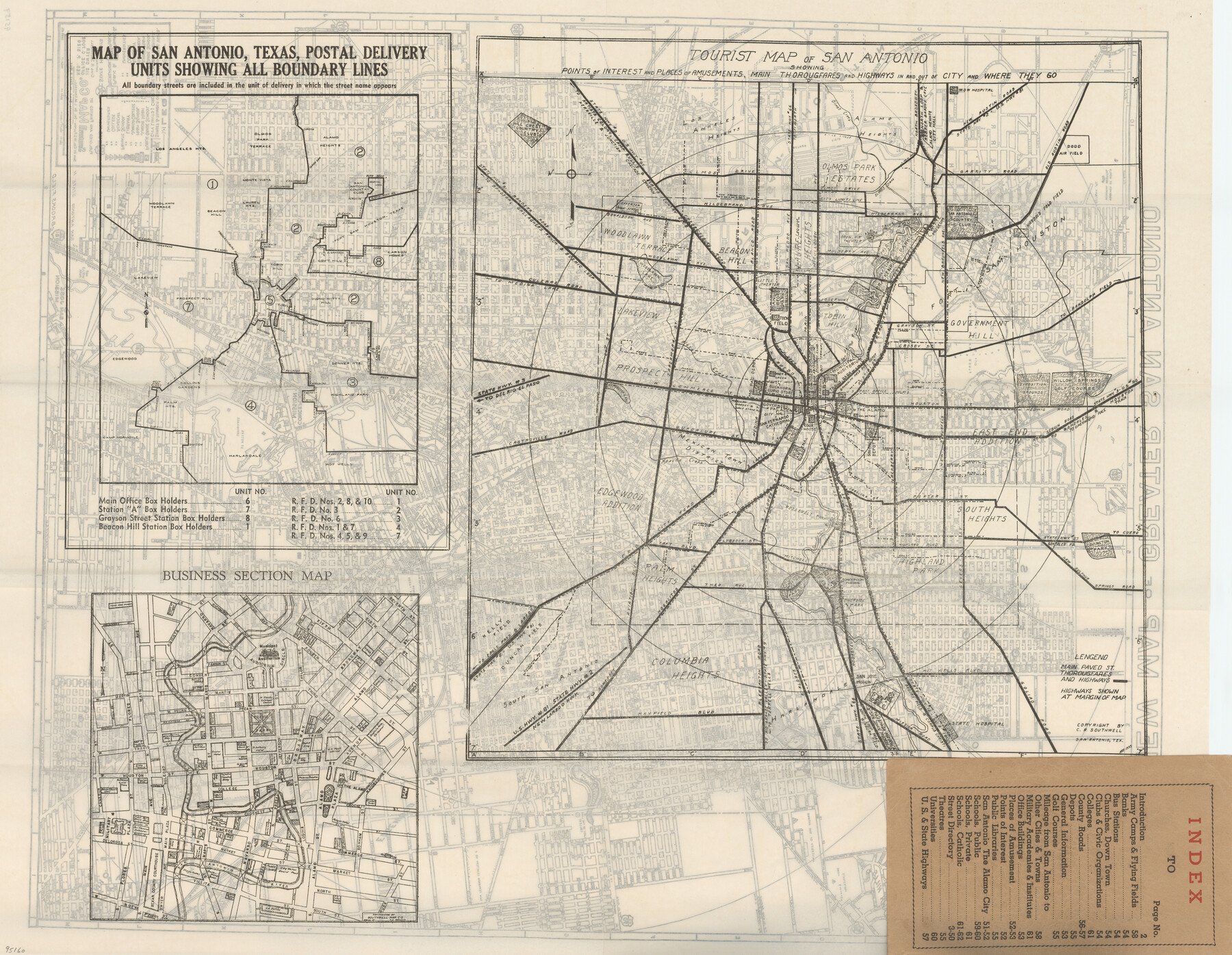
Map of San Antonio, Texas, Postal Delivery Units showing all boundary lines / Tourist Map of San Antonio showing points of interest and places of amusements, main thoroughfares and highways in and out of city and where they go / Business Section Map
-
Map/Doc
95160
-
Collection
General Map Collection
-
Object Dates
1944 (Publication Date)
-
People and Organizations
Southwell Map Company (Publisher)
-
Height x Width
18.0 x 24.0 inches
45.7 x 61.0 cm
-
Medium
paper, etching/engraving/lithograph
-
Comments
Map was originally part of the "New Street Guide of Greater San Antonio with Key Map".
Recto (Map 95159) contains "New Map of Greater San Antonio".
Map copyrighted and unavailable for duplication - for research only.
Related maps

Part of: General Map Collection
Upton County Working Sketch 40

Print $40.00
- Digital $50.00
Upton County Working Sketch 40
1959
Size 37.5 x 63.7 inches
Map/Doc 69536
Live Oak County Working Sketch 37

Print $40.00
- Digital $50.00
Live Oak County Working Sketch 37
2012
Size 34.4 x 48.7 inches
Map/Doc 93363
Duval County Sketch File 63

Print $4.00
- Digital $50.00
Duval County Sketch File 63
Size 14.5 x 8.9 inches
Map/Doc 21436
Galveston County Working Sketch 3

Print $20.00
- Digital $50.00
Galveston County Working Sketch 3
1915
Size 21.4 x 19.5 inches
Map/Doc 69340
Victoria County Rolled Sketch 9

Print $20.00
- Digital $50.00
Victoria County Rolled Sketch 9
Size 24.1 x 36.2 inches
Map/Doc 95399
Map of the City of Aransas Pass

Print $20.00
- Digital $50.00
Map of the City of Aransas Pass
1905
Size 28.3 x 21.4 inches
Map/Doc 97266
Upshur County Rolled Sketch 6

Print $20.00
- Digital $50.00
Upshur County Rolled Sketch 6
2003
Size 37.0 x 25.1 inches
Map/Doc 81941
Flight Mission No. DCL-7C, Frame 75, Kenedy County

Print $20.00
- Digital $50.00
Flight Mission No. DCL-7C, Frame 75, Kenedy County
1943
Size 15.3 x 15.2 inches
Map/Doc 86061
Johnson County Working Sketch 9

Print $20.00
- Digital $50.00
Johnson County Working Sketch 9
1953
Size 20.4 x 15.2 inches
Map/Doc 66622
Brewster County Working Sketch 4

Print $20.00
- Digital $50.00
Brewster County Working Sketch 4
1908
Size 15.7 x 20.5 inches
Map/Doc 67537
Hansford County

Print $20.00
- Digital $50.00
Hansford County
1932
Size 39.7 x 39.0 inches
Map/Doc 95519
No. 3 Chart of Channel connecting Corpus Christi Bay with Aransas Bay, Texas

Print $20.00
- Digital $50.00
No. 3 Chart of Channel connecting Corpus Christi Bay with Aransas Bay, Texas
1878
Size 18.4 x 28.0 inches
Map/Doc 72771
You may also like
Harris County Sketch File 61

Print $20.00
- Digital $50.00
Harris County Sketch File 61
1927
Size 19.4 x 16.7 inches
Map/Doc 11659
Map of Africa designed to accompany Smith's Geography for Schools

Print $20.00
- Digital $50.00
Map of Africa designed to accompany Smith's Geography for Schools
1850
Size 9.7 x 12.0 inches
Map/Doc 93897
[WWI Topographic Planning Map of the Ardennes department] - Verso
![94130, [WWI Topographic Planning Map of the Ardennes department] - Verso, Non-GLO Digital Images](https://historictexasmaps.com/wmedia_w700/maps/94130-1.tif.jpg)
Print $20.00
[WWI Topographic Planning Map of the Ardennes department] - Verso
1918
Size 35.9 x 20.4 inches
Map/Doc 94130
Concho County Rolled Sketch 2

Print $20.00
- Digital $50.00
Concho County Rolled Sketch 2
1887
Size 39.2 x 38.6 inches
Map/Doc 8647
Flight Mission No. CRC-5R, Frame 26, Chambers County

Print $20.00
- Digital $50.00
Flight Mission No. CRC-5R, Frame 26, Chambers County
1956
Size 18.6 x 22.5 inches
Map/Doc 84948
The Yellow Rose Compass

Price $20.00
The Yellow Rose Compass
2025
Size 3.5 x 2.8 inches
Map/Doc 97508
General Highway Map, Hale County, Texas

Print $20.00
General Highway Map, Hale County, Texas
1940
Size 24.8 x 18.4 inches
Map/Doc 79108
[Surveys in Southeast part of Stephens County]
![91909, [Surveys in Southeast part of Stephens County], Twichell Survey Records](https://historictexasmaps.com/wmedia_w700/maps/91909-1.tif.jpg)
Print $2.00
- Digital $50.00
[Surveys in Southeast part of Stephens County]
Size 9.1 x 7.0 inches
Map/Doc 91909
San Augustine County Sketch File 7

Print $4.00
San Augustine County Sketch File 7
1858
Size 7.0 x 8.2 inches
Map/Doc 35646
Mills County Sketch File 6

Print $4.00
- Digital $50.00
Mills County Sketch File 6
Size 9.0 x 9.8 inches
Map/Doc 31655
Map of San Gabriel & Lampassas [sic] Surveys
![58, Map of San Gabriel & Lampassas [sic] Surveys, General Map Collection](https://historictexasmaps.com/wmedia_w700/maps/58.tif.jpg)
Print $20.00
- Digital $50.00
Map of San Gabriel & Lampassas [sic] Surveys
1841
Size 29.0 x 20.0 inches
Map/Doc 58
Flight Mission No. DAG-19K, Frame 56, Matagorda County

Print $20.00
- Digital $50.00
Flight Mission No. DAG-19K, Frame 56, Matagorda County
1952
Size 18.5 x 22.3 inches
Map/Doc 86383