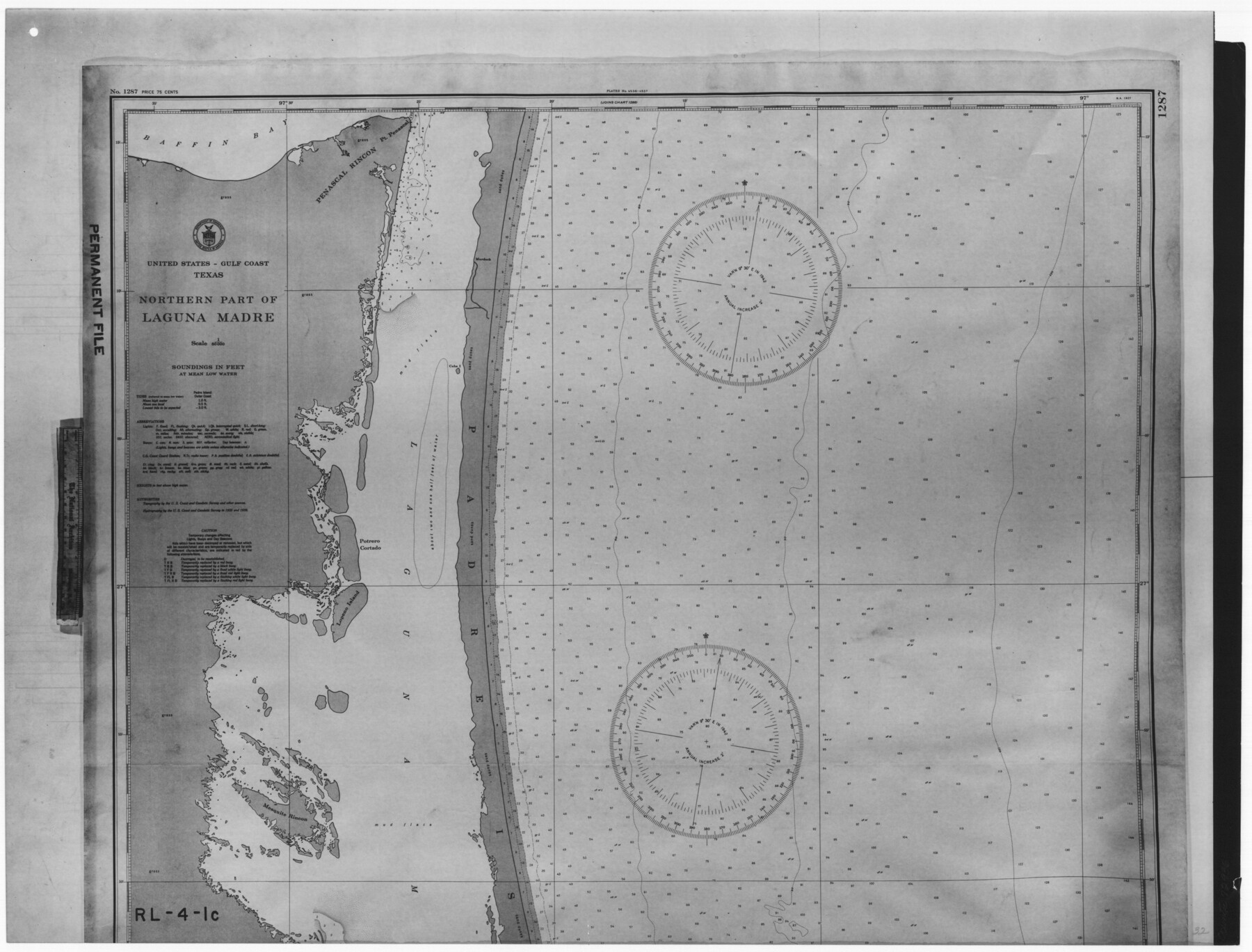
United States - Gulf Coast Texas - Northern part of Laguna Madre
RL-4-1c
-
Map/Doc
72936
-
Collection
General Map Collection
-
Object Dates
1941 (Creation Date)
-
People and Organizations
U. S. Coast and Geodetic Survey (Publisher)
U. S. Coast and Geodetic Survey (Author)
-
Subjects
Nautical Charts
-
Height x Width
18.4 x 24.2 inches
46.7 x 61.5 cm
-
Comments
B/W photostat copy from National Archives in multiple pieces.
Part of: General Map Collection
Chambers County Rolled Sketch 17

Print $20.00
- Digital $50.00
Chambers County Rolled Sketch 17
1936
Size 38.0 x 32.8 inches
Map/Doc 5425
Hudspeth County Working Sketch 41

Print $20.00
- Digital $50.00
Hudspeth County Working Sketch 41
1981
Size 18.3 x 37.1 inches
Map/Doc 66326
Flight Mission No. CRC-3R, Frame 91, Chambers County

Print $20.00
- Digital $50.00
Flight Mission No. CRC-3R, Frame 91, Chambers County
1956
Size 18.7 x 22.4 inches
Map/Doc 84829
Intracoastal Waterway, Houma, LA to Corpus Christi, TX

Print $4.00
- Digital $50.00
Intracoastal Waterway, Houma, LA to Corpus Christi, TX
Size 23.8 x 22.0 inches
Map/Doc 61910
Ashburn's 1951 Austin City Map

Ashburn's 1951 Austin City Map
1951
Size 22.5 x 17.4 inches
Map/Doc 97142
Coast Chart No. 210 Aransas Pass and Corpus Christi Bay with the coast to latitude 27° 12' Texas

Print $20.00
- Digital $50.00
Coast Chart No. 210 Aransas Pass and Corpus Christi Bay with the coast to latitude 27° 12' Texas
1913
Size 26.8 x 18.2 inches
Map/Doc 72808
Sutton County Working Sketch 66

Print $20.00
- Digital $50.00
Sutton County Working Sketch 66
1972
Size 29.0 x 39.3 inches
Map/Doc 62409
South Sulphur River, Harpers Crossing Sheet

Print $20.00
- Digital $50.00
South Sulphur River, Harpers Crossing Sheet
1925
Size 42.2 x 29.2 inches
Map/Doc 65169
Maps of Gulf Intracoastal Waterway, Texas - Sabine River to the Rio Grande and connecting waterways including ship channels

Print $20.00
- Digital $50.00
Maps of Gulf Intracoastal Waterway, Texas - Sabine River to the Rio Grande and connecting waterways including ship channels
1966
Size 14.6 x 21.0 inches
Map/Doc 61988
The Military History of Texas Map!

The Military History of Texas Map!
1996
Size 24.2 x 35.1 inches
Map/Doc 96827
Edwards County Working Sketch 23

Print $20.00
- Digital $50.00
Edwards County Working Sketch 23
1940
Size 24.0 x 25.6 inches
Map/Doc 68899
Matagorda County Sketch File 7c

Print $8.00
- Digital $50.00
Matagorda County Sketch File 7c
1890
Size 14.3 x 8.8 inches
Map/Doc 30746
You may also like
[Maps of surveys in Reeves & Culberson Cos]
![61140, [Maps of surveys in Reeves & Culberson Cos], General Map Collection](https://historictexasmaps.com/wmedia_w700/maps/61140.tif.jpg)
Print $20.00
- Digital $50.00
[Maps of surveys in Reeves & Culberson Cos]
1937
Size 30.6 x 24.9 inches
Map/Doc 61140
Fort Bend County

Print $20.00
- Digital $50.00
Fort Bend County
1892
Size 29.3 x 25.7 inches
Map/Doc 3551
Aransas County Sketch File 16

Print $40.00
- Digital $50.00
Aransas County Sketch File 16
1877
Size 16.4 x 12.8 inches
Map/Doc 13147
Flight Mission No. DQO-7K, Frame 82, Galveston County

Print $20.00
- Digital $50.00
Flight Mission No. DQO-7K, Frame 82, Galveston County
1952
Size 18.8 x 22.5 inches
Map/Doc 85109
Shackelford County Sketch File 4

Print $40.00
- Digital $50.00
Shackelford County Sketch File 4
Size 38.5 x 53.7 inches
Map/Doc 10600
Flight Mission No. CRC-4R, Frame 179, Chambers County

Print $20.00
- Digital $50.00
Flight Mission No. CRC-4R, Frame 179, Chambers County
1956
Size 18.6 x 22.3 inches
Map/Doc 84930
[Texas & Pacific Railway through Callahan County]
![64239, [Texas & Pacific Railway through Callahan County], General Map Collection](https://historictexasmaps.com/wmedia_w700/maps/64239.tif.jpg)
Print $20.00
- Digital $50.00
[Texas & Pacific Railway through Callahan County]
1918
Size 21.1 x 9.3 inches
Map/Doc 64239
Trace d'une partie Chemin de Fer de Galveston à Houston et Henderson, Texas, Etats unis d'Amérique

Print $20.00
- Digital $50.00
Trace d'une partie Chemin de Fer de Galveston à Houston et Henderson, Texas, Etats unis d'Amérique
1857
Size 17.1 x 21.8 inches
Map/Doc 93905
Colorado County Working Sketch 30

Print $20.00
- Digital $50.00
Colorado County Working Sketch 30
1980
Size 22.2 x 19.8 inches
Map/Doc 68130
Foard County Boundary File 5a

Print $40.00
- Digital $50.00
Foard County Boundary File 5a
Size 18.2 x 44.4 inches
Map/Doc 53546
Duval County Sketch File 35b

Print $6.00
- Digital $50.00
Duval County Sketch File 35b
1935
Size 14.4 x 8.8 inches
Map/Doc 21374
Maverick County Sketch File 28

Print $4.00
- Digital $50.00
Maverick County Sketch File 28
1893
Size 11.0 x 8.9 inches
Map/Doc 31163