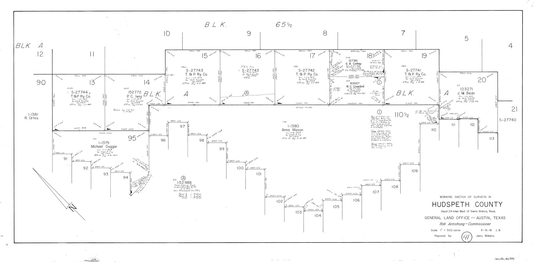
Hudspeth County Working Sketch 41
-
Map/Doc
66326
-
Collection
General Map Collection
-
Object Dates
4/15/1981 (Creation Date)
-
People and Organizations
Jana Brod (Draftsman)
-
Counties
Hudspeth
-
Subjects
Surveying Working Sketch
-
Height x Width
18.3 x 37.1 inches
46.5 x 94.2 cm
-
Scale
1" = 500 varas
Part of: General Map Collection
Gaines County Boundary File 1

Print $90.00
- Digital $50.00
Gaines County Boundary File 1
Size 14.4 x 9.0 inches
Map/Doc 53626
Crockett County Working Sketch 20

Print $20.00
- Digital $50.00
Crockett County Working Sketch 20
1920
Size 43.7 x 27.6 inches
Map/Doc 68353
Erforschung von Nordwest-Texas

Print $20.00
- Digital $50.00
Erforschung von Nordwest-Texas
Size 11.4 x 9.4 inches
Map/Doc 95144
Red River County Sketch File 17b

Print $4.00
- Digital $50.00
Red River County Sketch File 17b
1875
Size 12.9 x 8.1 inches
Map/Doc 35147
Castro County Working Sketch 5

Print $20.00
- Digital $50.00
Castro County Working Sketch 5
1943
Size 11.9 x 18.3 inches
Map/Doc 67900
Stephens County Sketch File 10

Print $4.00
- Digital $50.00
Stephens County Sketch File 10
Size 10.8 x 8.4 inches
Map/Doc 37042
Hill County Sketch File 26

Print $12.00
- Digital $50.00
Hill County Sketch File 26
1892
Size 8.9 x 8.5 inches
Map/Doc 26522
Galveston to Rio Grande

Print $20.00
- Digital $50.00
Galveston to Rio Grande
1946
Size 44.8 x 36.9 inches
Map/Doc 69953
Montgomery County Working Sketch 57

Print $20.00
- Digital $50.00
Montgomery County Working Sketch 57
1961
Size 24.2 x 26.6 inches
Map/Doc 71164
Crockett County Sketch File 58a

Print $20.00
- Digital $50.00
Crockett County Sketch File 58a
1923
Size 21.1 x 25.8 inches
Map/Doc 5601
Galveston County Aerial Photograph Index Sheet 4

Print $20.00
- Digital $50.00
Galveston County Aerial Photograph Index Sheet 4
1953
Size 23.5 x 19.4 inches
Map/Doc 83695
Uvalde County Working Sketch 56

Print $20.00
- Digital $50.00
Uvalde County Working Sketch 56
1985
Size 44.8 x 40.6 inches
Map/Doc 72126
You may also like
Presidio County Sketch File 47

Print $16.00
- Digital $50.00
Presidio County Sketch File 47
1918
Size 7.2 x 8.1 inches
Map/Doc 34574
Map of The Surveyed Part of Peters Colony Texas

Print $40.00
- Digital $50.00
Map of The Surveyed Part of Peters Colony Texas
1852
Size 54.0 x 28.8 inches
Map/Doc 3155
[Block A, Greer County, Texas]
![384, [Block A, Greer County, Texas], Maddox Collection](https://historictexasmaps.com/wmedia_w700/maps/384.tif.jpg)
Print $20.00
- Digital $50.00
[Block A, Greer County, Texas]
Size 16.9 x 15.8 inches
Map/Doc 384
Armstrong County Sketch File A-2

Print $40.00
- Digital $50.00
Armstrong County Sketch File A-2
1918
Size 27.0 x 36.6 inches
Map/Doc 10843
Map of a part of Laguna Madre showing subdivision for mineral development

Print $20.00
- Digital $50.00
Map of a part of Laguna Madre showing subdivision for mineral development
1948
Size 37.4 x 27.7 inches
Map/Doc 2914
Gonzales County Sketch File 11

Print $4.00
- Digital $50.00
Gonzales County Sketch File 11
1842
Size 12.8 x 7.9 inches
Map/Doc 24392
Map of Surveys on Harbor Island

Print $40.00
- Digital $50.00
Map of Surveys on Harbor Island
1912
Size 57.3 x 42.2 inches
Map/Doc 594
Presidio County Sketch File 27 1/2

Print $6.00
- Digital $50.00
Presidio County Sketch File 27 1/2
1890
Size 11.0 x 13.5 inches
Map/Doc 34466
Presidio County Boundary File 3b

Print $14.00
- Digital $50.00
Presidio County Boundary File 3b
Size 13.4 x 8.2 inches
Map/Doc 58076
Map No. 1 - Rio Bravo del Norte section of boundary between the United States & Mexico agreed upon by the Joint Commission under the Treaty of Guadalupe Hidalgo

Print $20.00
- Digital $50.00
Map No. 1 - Rio Bravo del Norte section of boundary between the United States & Mexico agreed upon by the Joint Commission under the Treaty of Guadalupe Hidalgo
1852
Size 18.4 x 27.0 inches
Map/Doc 72866
Jackson County Sketch File 6

Print $4.00
- Digital $50.00
Jackson County Sketch File 6
1897
Size 13.1 x 8.9 inches
Map/Doc 27632
La Salle County Working Sketch 53

Print $20.00
- Digital $50.00
La Salle County Working Sketch 53
Size 14.3 x 15.9 inches
Map/Doc 67362