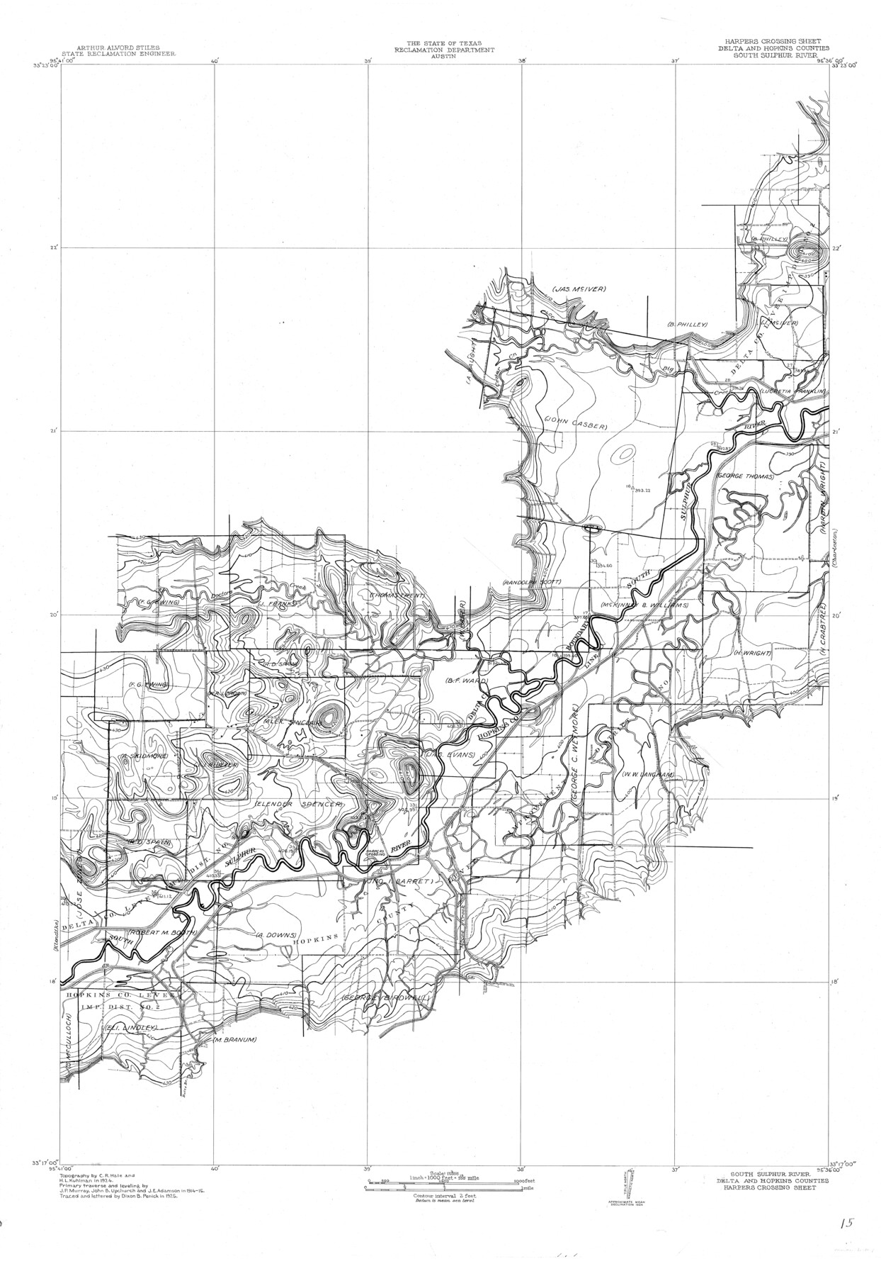
South Sulphur River, Harpers Crossing Sheet
-
Map/Doc
65169
-
Collection
General Map Collection
-
Object Dates
1925 (Creation Date)
-
People and Organizations
Texas State Reclamation Department (Publisher)
Dixon B. Penick (Compiler)
Dixon B. Penick (Draftsman)
Curtis R. Hale (Surveyor/Engineer)
H.L. Kuhllman (Surveyor/Engineer)
-
Counties
Delta Hopkins
-
Subjects
River Surveys Topographic
-
Height x Width
42.2 x 29.2 inches
107.2 x 74.2 cm
-
Comments
Harper's Crossing Sheet located between the Klondike Sheet and the Charleston sheet.
Part of: General Map Collection
Brown County Working Sketch 13

Print $20.00
- Digital $50.00
Brown County Working Sketch 13
1985
Size 34.1 x 30.4 inches
Map/Doc 67778
Controlled Mosaic by Jack Amman Photogrammetric Engineers, Inc - Sheet 53

Print $20.00
- Digital $50.00
Controlled Mosaic by Jack Amman Photogrammetric Engineers, Inc - Sheet 53
1954
Size 20.0 x 24.0 inches
Map/Doc 83512
Real County Working Sketch 17

Print $20.00
- Digital $50.00
Real County Working Sketch 17
1941
Size 18.8 x 24.3 inches
Map/Doc 71909
Map of DeWitt County

Print $20.00
- Digital $50.00
Map of DeWitt County
1853
Size 21.5 x 25.5 inches
Map/Doc 3479
Comanche County Rolled Sketch 1

Print $20.00
- Digital $50.00
Comanche County Rolled Sketch 1
1985
Size 24.1 x 18.7 inches
Map/Doc 5542
Uvalde County Rolled Sketch 7

Print $20.00
- Digital $50.00
Uvalde County Rolled Sketch 7
1946
Size 23.8 x 15.7 inches
Map/Doc 8092
Austin County Sketch File 2

Print $4.00
- Digital $50.00
Austin County Sketch File 2
Size 8.2 x 6.3 inches
Map/Doc 13855
Brewster County Rolled Sketch 24A

Print $20.00
- Digital $50.00
Brewster County Rolled Sketch 24A
1910
Size 19.8 x 26.1 inches
Map/Doc 5208
Wharton County Rolled Sketch 3

Print $20.00
- Digital $50.00
Wharton County Rolled Sketch 3
Size 28.9 x 31.4 inches
Map/Doc 8228
Cochran County Boundary File 5

Print $12.00
- Digital $50.00
Cochran County Boundary File 5
Size 4.2 x 8.8 inches
Map/Doc 51556
Map of section no. 7 of a survey of Padre Island made for the Office of the Attorney General of the State of Texas

Print $40.00
- Digital $50.00
Map of section no. 7 of a survey of Padre Island made for the Office of the Attorney General of the State of Texas
1941
Size 56.3 x 41.2 inches
Map/Doc 2263
Coast Chart No. 212 - From Latitude 26° 33' to the Rio Grande Texas

Print $20.00
- Digital $50.00
Coast Chart No. 212 - From Latitude 26° 33' to the Rio Grande Texas
1886
Size 27.7 x 18.3 inches
Map/Doc 72828
You may also like
Flight Mission No. DCL-7C, Frame 47, Kenedy County

Print $20.00
- Digital $50.00
Flight Mission No. DCL-7C, Frame 47, Kenedy County
1943
Size 15.3 x 15.3 inches
Map/Doc 86035
Upshur County Sketch File 8

Print $22.00
- Digital $50.00
Upshur County Sketch File 8
1857
Size 20.4 x 8.2 inches
Map/Doc 38746
Cottle County

Print $20.00
- Digital $50.00
Cottle County
1971
Size 43.4 x 36.0 inches
Map/Doc 95467
Flight Mission No. CRK-3P, Frame 62, Refugio County

Print $20.00
- Digital $50.00
Flight Mission No. CRK-3P, Frame 62, Refugio County
1956
Size 18.6 x 22.6 inches
Map/Doc 86904
Zavala County Sketch File 44

Print $25.00
- Digital $50.00
Zavala County Sketch File 44
1915
Size 10.1 x 14.3 inches
Map/Doc 41416
Freestone County Working Sketch 3

Print $20.00
- Digital $50.00
Freestone County Working Sketch 3
1914
Size 18.8 x 16.2 inches
Map/Doc 69245
Mills County Sketch File 25

Print $8.00
- Digital $50.00
Mills County Sketch File 25
1949
Size 11.3 x 8.8 inches
Map/Doc 31674
Texas Coast, No. 17

Print $20.00
- Digital $50.00
Texas Coast, No. 17
Size 18.3 x 26.1 inches
Map/Doc 72713
[Southwest 1/4 of Northwest 1/4 of County in vicinity of surveys 1281, 1282, 1297 and 1302]
![90897, [Southwest 1/4 of Northwest 1/4 of County in vicinity of surveys 1281, 1282, 1297 and 1302], Twichell Survey Records](https://historictexasmaps.com/wmedia_w700/maps/90897-1.tif.jpg)
Print $20.00
- Digital $50.00
[Southwest 1/4 of Northwest 1/4 of County in vicinity of surveys 1281, 1282, 1297 and 1302]
Size 21.5 x 14.2 inches
Map/Doc 90897
Presidio County Rolled Sketch S2

Print $20.00
- Digital $50.00
Presidio County Rolled Sketch S2
1916
Size 14.2 x 12.0 inches
Map/Doc 7415
Upton County Sketch File 32

Print $20.00
- Digital $50.00
Upton County Sketch File 32
1938
Size 14.9 x 24.0 inches
Map/Doc 12523
Brazoria County Working Sketch 34

Print $20.00
- Digital $50.00
Brazoria County Working Sketch 34
1981
Size 15.8 x 19.0 inches
Map/Doc 67519