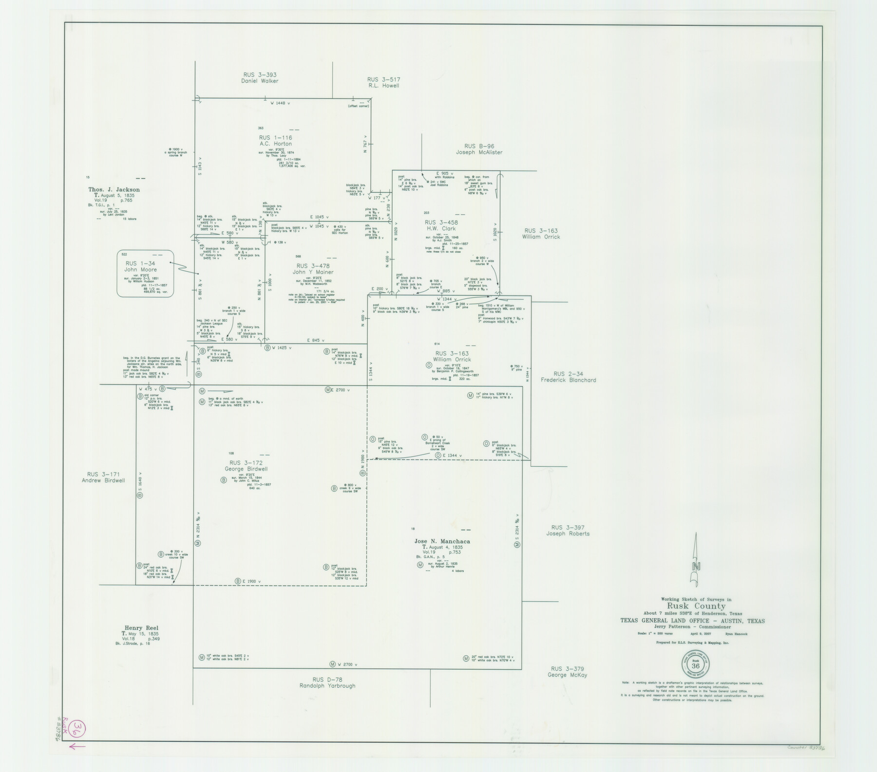
Rusk County Working Sketch 36
-
Map/Doc
83786
-
Collection
General Map Collection
-
Object Dates
4/9/2007 (Creation Date)
-
People and Organizations
Ryan Hancock (Draftsman)
-
Counties
Rusk
-
Subjects
Surveying Working Sketch
-
Height x Width
31.7 x 36.0 inches
80.5 x 91.4 cm
-
Scale
1" = 200 varas
-
Comments
Surveys located about seven miles South 38 degrees East of Henderson, Texas.
Part of: General Map Collection
Laguna Madre, T-9211

Print $20.00
- Digital $50.00
Laguna Madre, T-9211
Size 33.0 x 31.1 inches
Map/Doc 73602
Zapata County

Print $40.00
- Digital $50.00
Zapata County
1935
Size 56.2 x 41.9 inches
Map/Doc 95683
Reagan County Rolled Sketch R

Print $20.00
- Digital $50.00
Reagan County Rolled Sketch R
Size 33.0 x 31.0 inches
Map/Doc 10734
Kimble County Working Sketch 40

Print $40.00
- Digital $50.00
Kimble County Working Sketch 40
1948
Size 53.0 x 38.4 inches
Map/Doc 70108
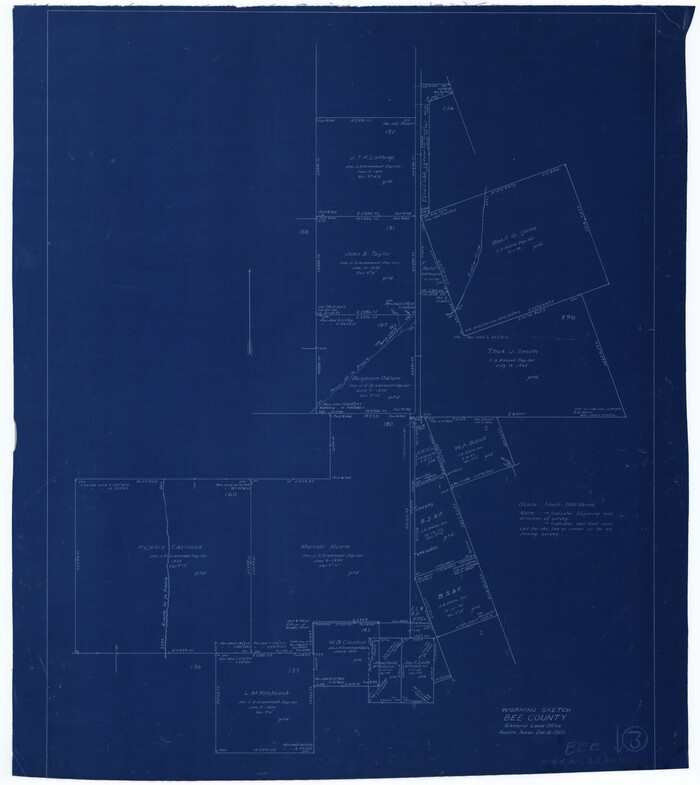
Bee County Working Sketch 3
Print $20.00
- Digital $50.00
Bee County Working Sketch 3
1915
Size 22.8 x 20.3 inches
Map/Doc 67253

Terrell County Working Sketch 33

Print $20.00
- Digital $50.00
Terrell County Working Sketch 33
1945
Size 16.1 x 31.6 inches
Map/Doc 62125
[Sketch for Mineral Application 26501 - Sabine River, T. A. Oldhausen]
![2832, [Sketch for Mineral Application 26501 - Sabine River, T. A. Oldhausen], General Map Collection](https://historictexasmaps.com/wmedia_w700/maps/2832.tif.jpg)
Print $20.00
- Digital $50.00
[Sketch for Mineral Application 26501 - Sabine River, T. A. Oldhausen]
1931
Size 24.0 x 36.0 inches
Map/Doc 2832
Presidio County Working Sketch 108

Print $20.00
- Digital $50.00
Presidio County Working Sketch 108
1980
Size 39.9 x 21.7 inches
Map/Doc 71785
Shelby County Working Sketch 28

Print $20.00
- Digital $50.00
Shelby County Working Sketch 28
2000
Size 28.8 x 29.8 inches
Map/Doc 63882
Railroad and County Map of Texas

Print $20.00
- Digital $50.00
Railroad and County Map of Texas
1906
Size 46.0 x 47.6 inches
Map/Doc 10748
Edwards County Working Sketch 127

Print $20.00
- Digital $50.00
Edwards County Working Sketch 127
1980
Size 21.0 x 24.1 inches
Map/Doc 69003
You may also like
Texas Hill Country Trail Region

Texas Hill Country Trail Region
Size 18.1 x 24.2 inches
Map/Doc 96872
Limestone County Sketch File 7

Print $4.00
- Digital $50.00
Limestone County Sketch File 7
1862
Size 13.3 x 7.9 inches
Map/Doc 30169
Real County Rolled Sketch 10

Print $20.00
- Digital $50.00
Real County Rolled Sketch 10
Size 43.7 x 34.3 inches
Map/Doc 9835
Railroad Track Map, H&TCRRCo., Falls County, Texas

Print $4.00
- Digital $50.00
Railroad Track Map, H&TCRRCo., Falls County, Texas
1918
Size 11.7 x 18.7 inches
Map/Doc 62845
Map of Texas Compiled from surveys recorded in the General Land Office

Print $20.00
Map of Texas Compiled from surveys recorded in the General Land Office
1851
Size 31.4 x 25.3 inches
Map/Doc 76209
General Highway Map, Starr County, Texas

Print $20.00
General Highway Map, Starr County, Texas
1940
Size 24.7 x 18.5 inches
Map/Doc 79245
Flight Mission No. DQN-1K, Frame 141, Calhoun County

Print $20.00
- Digital $50.00
Flight Mission No. DQN-1K, Frame 141, Calhoun County
1953
Size 18.5 x 22.1 inches
Map/Doc 84204
Maps of the new and popular St. Louis and Texas Short Line composed of the St. Louis, Iron Mountain & Southern, Texas & Pacific and International & Great Northern Railways

Print $20.00
- Digital $50.00
Maps of the new and popular St. Louis and Texas Short Line composed of the St. Louis, Iron Mountain & Southern, Texas & Pacific and International & Great Northern Railways
1874
Size 19.0 x 32.0 inches
Map/Doc 93638
Haskell County Working Sketch 7

Print $40.00
- Digital $50.00
Haskell County Working Sketch 7
1956
Size 52.1 x 39.0 inches
Map/Doc 66065
La Salle County Rolled Sketch 17

Print $20.00
- Digital $50.00
La Salle County Rolled Sketch 17
Size 26.5 x 29.9 inches
Map/Doc 6581
Stonewall County Rolled Sketch 31

Print $20.00
- Digital $50.00
Stonewall County Rolled Sketch 31
1982
Size 25.6 x 42.9 inches
Map/Doc 7875
Flight Mission No. CRC-4R, Frame 173, Chambers County

Print $20.00
- Digital $50.00
Flight Mission No. CRC-4R, Frame 173, Chambers County
1956
Size 18.7 x 22.3 inches
Map/Doc 84924