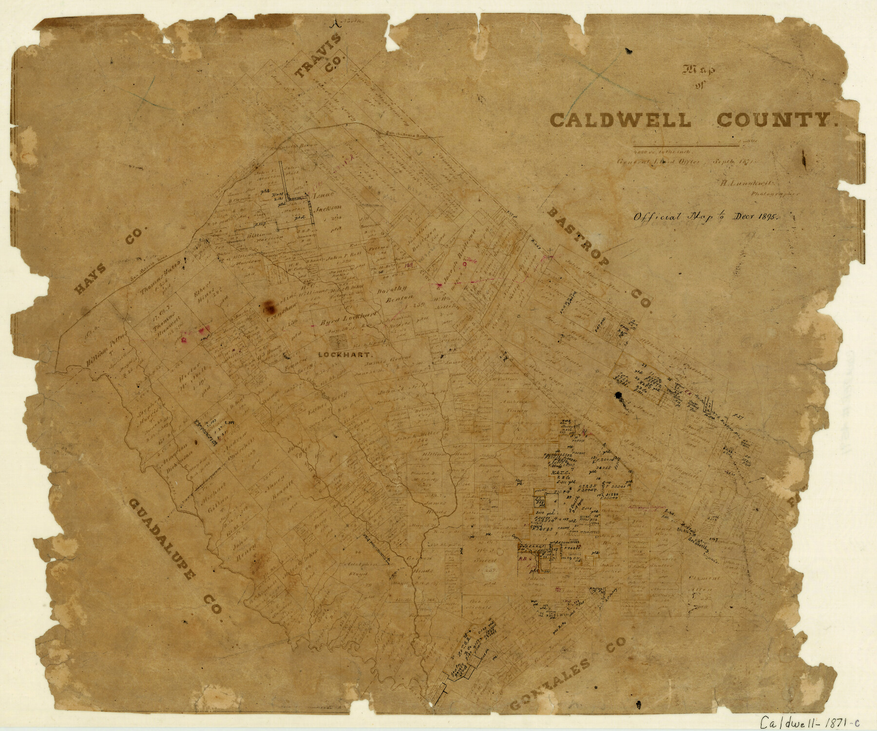
Map of Caldwell County
-
Map/Doc
4591
-
Collection
General Map Collection
-
Object Dates
9/1871 (Creation Date)
-
People and Organizations
Herman Lungkwitz (Draftsman)
-
Counties
Caldwell
-
Subjects
County
-
Height x Width
16.9 x 19.9 inches
42.9 x 50.6 cm
-
Comments
Note on map: "Official map to December 1895".
-
Features
San Antonio Road
Plum Creek
Lockhart
Clear Fork of San Marcos River
San Marcos River
West Fork of San Marcos River
Copperas Creek
Mule Creek
Part of: General Map Collection
Archer County Sketch File 23

Print $40.00
- Digital $50.00
Archer County Sketch File 23
1936
Size 25.3 x 23.4 inches
Map/Doc 10831
Grayson County

Print $20.00
- Digital $50.00
Grayson County
1935
Size 42.4 x 39.5 inches
Map/Doc 73162
El Paso County Rolled Sketch 52

Print $20.00
- Digital $50.00
El Paso County Rolled Sketch 52
1930
Size 18.5 x 24.4 inches
Map/Doc 5837
Loving County Working Sketch 21

Print $20.00
- Digital $50.00
Loving County Working Sketch 21
1984
Size 26.7 x 36.0 inches
Map/Doc 70655
Walker County Working Sketch 10

Print $20.00
- Digital $50.00
Walker County Working Sketch 10
1935
Size 19.3 x 19.9 inches
Map/Doc 72290
Leon County Rolled Sketch 19

Print $20.00
- Digital $50.00
Leon County Rolled Sketch 19
1982
Size 23.9 x 37.4 inches
Map/Doc 6605
Panola County Working Sketch 31

Print $20.00
- Digital $50.00
Panola County Working Sketch 31
1981
Map/Doc 71440
Dimmit County Boundary File 3

Print $12.00
- Digital $50.00
Dimmit County Boundary File 3
Size 14.4 x 8.9 inches
Map/Doc 52566
Flight Mission No. DQO-8K, Frame 135, Galveston County

Print $20.00
- Digital $50.00
Flight Mission No. DQO-8K, Frame 135, Galveston County
1952
Size 18.7 x 22.5 inches
Map/Doc 85200
Flight Mission No. DQO-8K, Frame 87, Galveston County

Print $20.00
- Digital $50.00
Flight Mission No. DQO-8K, Frame 87, Galveston County
1952
Size 18.6 x 22.4 inches
Map/Doc 85189
Texas Gulf Coast from the Sabine River to the Rio Grande Showing Location of Navigation Districts

Print $20.00
- Digital $50.00
Texas Gulf Coast from the Sabine River to the Rio Grande Showing Location of Navigation Districts
1954
Size 45.0 x 43.8 inches
Map/Doc 73596
Anderson County Sketch File 22

Print $40.00
- Digital $50.00
Anderson County Sketch File 22
1925
Size 38.0 x 37.5 inches
Map/Doc 10315
You may also like
San Jacinto County Working Sketch 41

Print $20.00
- Digital $50.00
San Jacinto County Working Sketch 41
1979
Size 44.6 x 35.2 inches
Map/Doc 63754
Hudspeth County Working Sketch 47

Print $20.00
- Digital $50.00
Hudspeth County Working Sketch 47
1984
Size 27.3 x 38.6 inches
Map/Doc 78211
Flight Mission No. CUG-1P, Frame 163, Kleberg County

Print $20.00
- Digital $50.00
Flight Mission No. CUG-1P, Frame 163, Kleberg County
1956
Size 18.6 x 22.2 inches
Map/Doc 86170
Flight Mission No. CRC-4R, Frame 162, Chambers County

Print $20.00
- Digital $50.00
Flight Mission No. CRC-4R, Frame 162, Chambers County
1956
Size 18.6 x 22.4 inches
Map/Doc 84921
Young County Working Sketch 22

Print $20.00
- Digital $50.00
Young County Working Sketch 22
1965
Size 26.5 x 32.3 inches
Map/Doc 62045
Wharton County Sketch File 10a

Print $20.00
- Digital $50.00
Wharton County Sketch File 10a
Size 11.0 x 19.0 inches
Map/Doc 12660
Mason County Boundary File 6

Print $28.00
- Digital $50.00
Mason County Boundary File 6
Size 14.3 x 8.9 inches
Map/Doc 56874
Flight Mission No. BRA-16M, Frame 169, Jefferson County

Print $20.00
- Digital $50.00
Flight Mission No. BRA-16M, Frame 169, Jefferson County
1953
Size 18.7 x 22.6 inches
Map/Doc 85767
Flight Mission No. DQN-2K, Frame 32, Calhoun County

Print $20.00
- Digital $50.00
Flight Mission No. DQN-2K, Frame 32, Calhoun County
1953
Size 18.7 x 22.3 inches
Map/Doc 84239

Amistad International Reservoir on Rio Grande 93

Print $20.00
- Digital $50.00
Amistad International Reservoir on Rio Grande 93
1950
Size 28.5 x 40.7 inches
Map/Doc 75523
A Map of Dallas County

Print $20.00
- Digital $50.00
A Map of Dallas County
1854
Size 20.9 x 16.6 inches
Map/Doc 4526