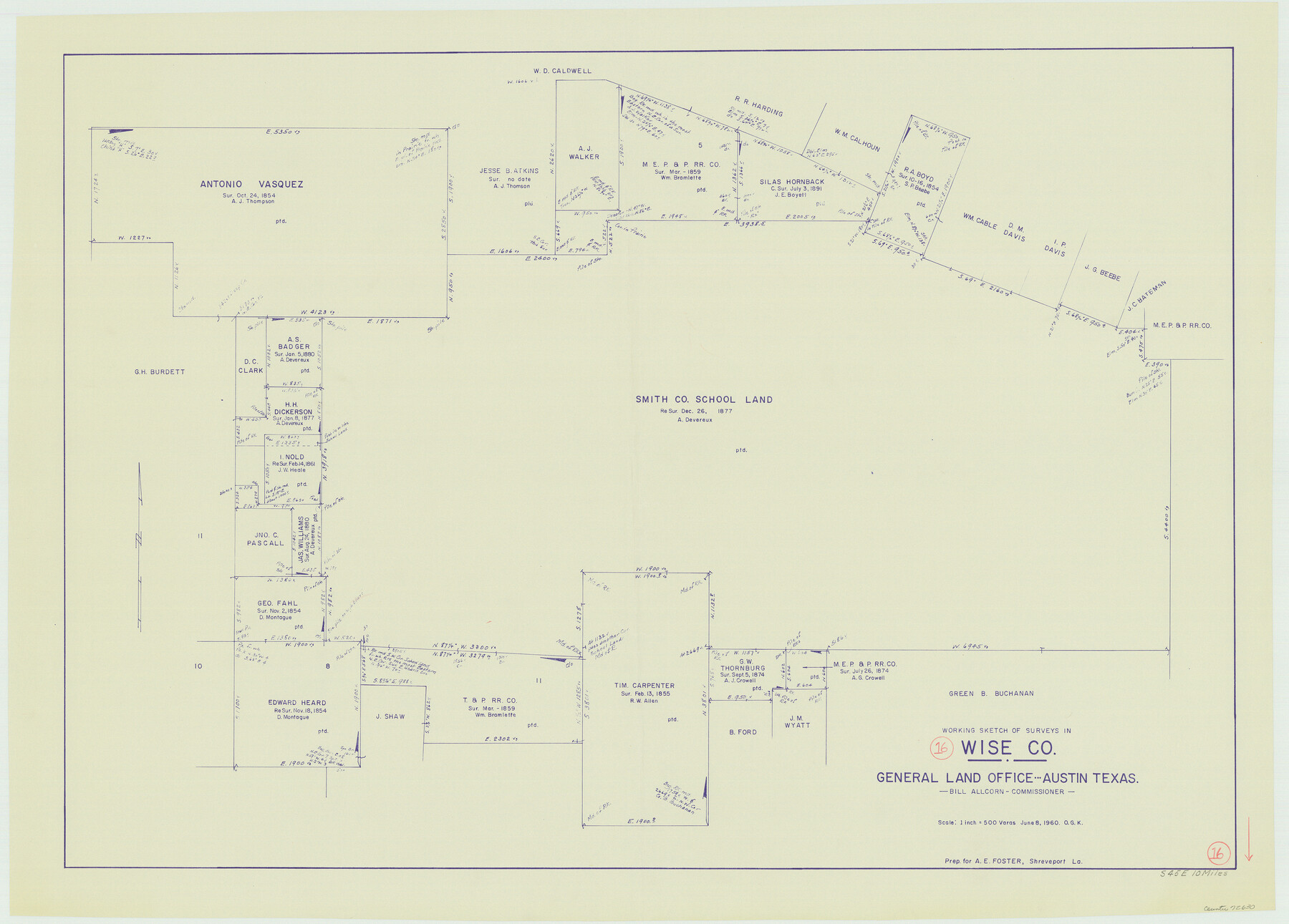
Wise County Working Sketch 16
-
Map/Doc
72630
-
Collection
General Map Collection
-
Object Dates
6/8/1960 (Creation Date)
-
People and Organizations
Otto G. Kurio (Draftsman)
-
Counties
Wise
-
Subjects
Surveying Working Sketch
-
Height x Width
28.0 x 39.0 inches
71.1 x 99.1 cm
-
Scale
1" = 500 varas
Part of: General Map Collection
Hardin County Sketch File 65

Print $15.00
- Digital $50.00
Hardin County Sketch File 65
Size 14.4 x 9.0 inches
Map/Doc 25245
Terry County Boundary File 4

Print $64.00
- Digital $50.00
Terry County Boundary File 4
Size 14.5 x 8.9 inches
Map/Doc 59236
Visitors' Map of Galveston also showing County Shell Road to Houston

Print $20.00
- Digital $50.00
Visitors' Map of Galveston also showing County Shell Road to Houston
Size 19.6 x 23.9 inches
Map/Doc 95319
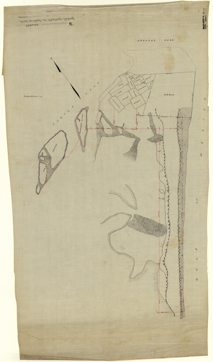
Nueces County Rolled Sketch 6
Print $20.00
- Digital $50.00
Nueces County Rolled Sketch 6
Size 37.8 x 22.2 inches
Map/Doc 6867
Cass County Sketch File 16

Print $4.00
- Digital $50.00
Cass County Sketch File 16
Size 8.5 x 12.8 inches
Map/Doc 17416
Jeff Davis County Sketch File 26 1/2

Print $10.00
- Digital $50.00
Jeff Davis County Sketch File 26 1/2
Size 9.0 x 10.4 inches
Map/Doc 27999
McMullen County

Print $40.00
- Digital $50.00
McMullen County
1918
Size 49.5 x 35.9 inches
Map/Doc 10788
Aransas County Rolled Sketch 1

Print $40.00
- Digital $50.00
Aransas County Rolled Sketch 1
1930
Size 12.5 x 50.0 inches
Map/Doc 8915

Cameron County Sketch File 10

Print $8.00
- Digital $50.00
Cameron County Sketch File 10
1989
Size 11.1 x 8.6 inches
Map/Doc 17205
Tarrant County Boundary File 4 and 4a

Print $14.00
- Digital $50.00
Tarrant County Boundary File 4 and 4a
Size 11.5 x 8.9 inches
Map/Doc 59154
Upshur County Sketch File 13

Print $4.00
- Digital $50.00
Upshur County Sketch File 13
1861
Size 8.2 x 8.3 inches
Map/Doc 38755
You may also like
Dimmit County Sketch File 24

Print $4.00
- Digital $50.00
Dimmit County Sketch File 24
1885
Size 13.0 x 8.7 inches
Map/Doc 21140
Denton County Working Sketch 23

Print $20.00
- Digital $50.00
Denton County Working Sketch 23
1982
Size 18.6 x 14.1 inches
Map/Doc 68628
Dickens County Sketch File 15

Print $4.00
- Digital $50.00
Dickens County Sketch File 15
Size 12.6 x 8.0 inches
Map/Doc 20973
Kleberg County Boundary File 1

Print $10.00
- Digital $50.00
Kleberg County Boundary File 1
Size 9.3 x 5.9 inches
Map/Doc 64961
Leon County Rolled Sketch 26

Print $40.00
- Digital $50.00
Leon County Rolled Sketch 26
Size 24.0 x 54.5 inches
Map/Doc 9435
General Highway Map, Young County, Texas

Print $20.00
General Highway Map, Young County, Texas
1940
Size 18.4 x 24.8 inches
Map/Doc 79286
Polk County Sketch File 28

Print $4.00
- Digital $50.00
Polk County Sketch File 28
Size 8.6 x 9.9 inches
Map/Doc 34198
Mitchell County Sketch File 18

Print $20.00
- Digital $50.00
Mitchell County Sketch File 18
Size 32.1 x 13.6 inches
Map/Doc 12103
General Highway Map Supplementary Sheet Showing Detail of Cities and Towns in Bexar County Texas

Print $20.00
General Highway Map Supplementary Sheet Showing Detail of Cities and Towns in Bexar County Texas
1936
Size 18.5 x 25.0 inches
Map/Doc 76290
Ellis County Boundary File 6

Print $22.00
- Digital $50.00
Ellis County Boundary File 6
Size 8.6 x 6.0 inches
Map/Doc 52992
Index for Texas Railroad ROW & track maps available on microfilm at THD & Archives and Records

Print $2.00
- Digital $50.00
Index for Texas Railroad ROW & track maps available on microfilm at THD & Archives and Records
1977
Size 11.3 x 8.6 inches
Map/Doc 60761
Brazoria County NRC Article 33.136 Sketch 16

Print $72.00
- Digital $50.00
Brazoria County NRC Article 33.136 Sketch 16
2014
Size 22.0 x 36.0 inches
Map/Doc 95037