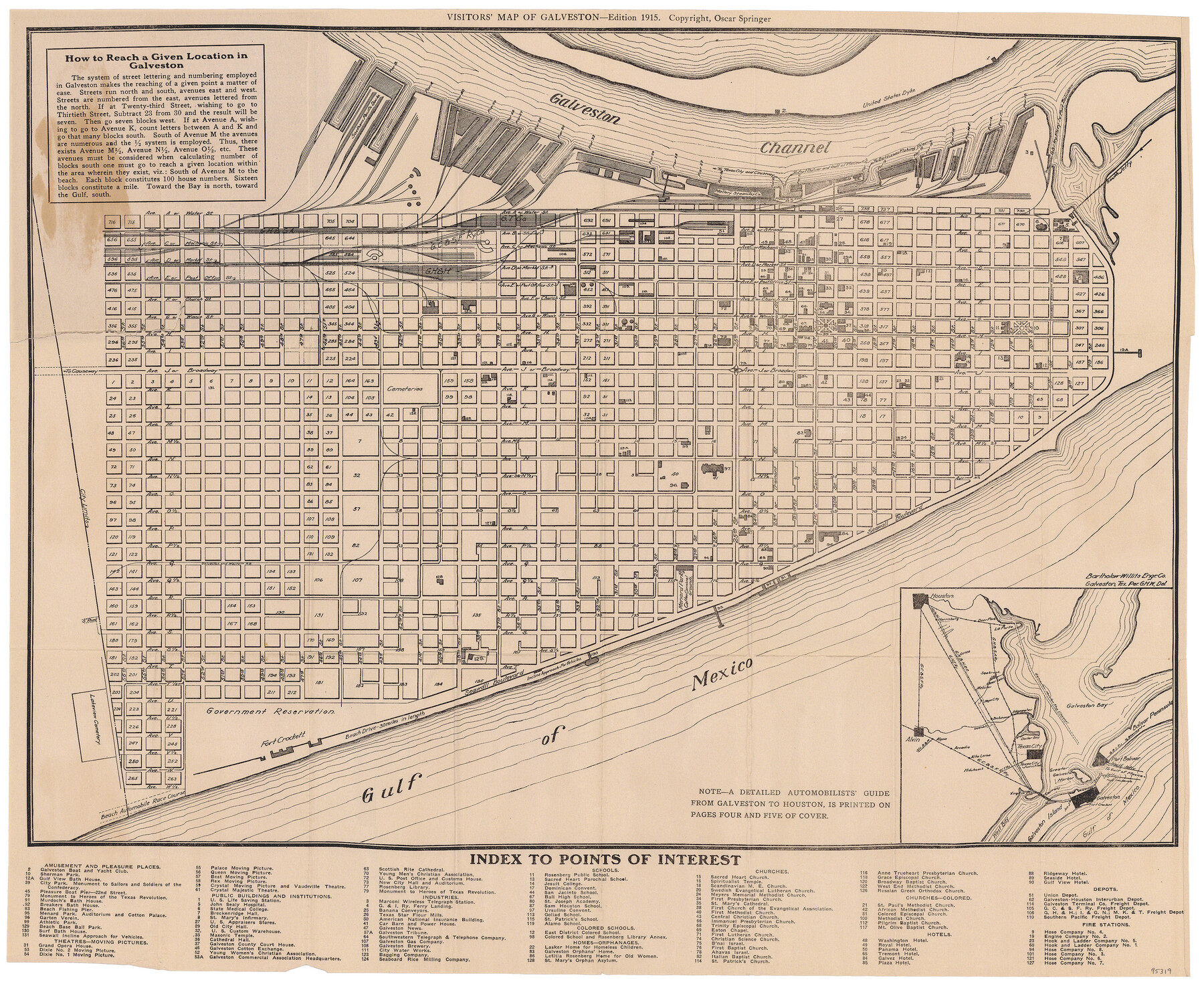
Visitors' Map of Galveston also showing County Shell Road to Houston
-
Map/Doc
95319
-
Collection
General Map Collection
-
Object Dates
1915 (Publication Date)
-
People and Organizations
Oscar Springer (Publisher)
Oscar Springer (Printer)
-
Counties
Galveston
-
Subjects
City
-
Height x Width
19.6 x 23.9 inches
49.8 x 60.7 cm
-
Medium
paper, etching/engraving/lithograph
-
Comments
To view original cover for this map, click "Download PDF" link above.
Part of: General Map Collection
Brazoria County Working Sketch 48

Print $20.00
- Digital $50.00
Brazoria County Working Sketch 48
1990
Size 25.2 x 29.5 inches
Map/Doc 67533
Flight Mission No. CRC-6R, Frame 37, Chambers County

Print $20.00
- Digital $50.00
Flight Mission No. CRC-6R, Frame 37, Chambers County
1956
Size 18.5 x 22.4 inches
Map/Doc 84970
Llano County Sketch File 19

Print $16.00
- Digital $50.00
Llano County Sketch File 19
1961
Size 14.2 x 8.7 inches
Map/Doc 30397
Sabine Pass and Lake

Print $20.00
- Digital $50.00
Sabine Pass and Lake
1925
Size 43.6 x 28.0 inches
Map/Doc 69821
Kimble County Working Sketch 17

Print $20.00
- Digital $50.00
Kimble County Working Sketch 17
1924
Size 27.8 x 22.5 inches
Map/Doc 70085
Jefferson County Sketch File 33

Print $32.00
- Digital $50.00
Jefferson County Sketch File 33
1934
Size 8.2 x 7.6 inches
Map/Doc 28197
Hill County Boundary File 1

Print $20.00
- Digital $50.00
Hill County Boundary File 1
Size 12.8 x 8.3 inches
Map/Doc 54722
[Galveston, Harrisburg & San Antonio Railway]
![64405, [Galveston, Harrisburg & San Antonio Railway], General Map Collection](https://historictexasmaps.com/wmedia_w700/maps/64405.tif.jpg)
Print $20.00
- Digital $50.00
[Galveston, Harrisburg & San Antonio Railway]
1892
Size 13.5 x 33.6 inches
Map/Doc 64405
Mills County Boundary File 6

Print $2.00
- Digital $50.00
Mills County Boundary File 6
Size 11.0 x 8.6 inches
Map/Doc 57311
Crockett County Sketch File 12

Print $20.00
- Digital $50.00
Crockett County Sketch File 12
Size 26.8 x 18.9 inches
Map/Doc 11216
La Salle County Working Sketch 30

Print $20.00
- Digital $50.00
La Salle County Working Sketch 30
1955
Size 34.6 x 28.9 inches
Map/Doc 70331
[Rio Grande & Eagle Pass - Stockdale to Cuero]
![64047, [Rio Grande & Eagle Pass - Stockdale to Cuero], General Map Collection](https://historictexasmaps.com/wmedia_w700/maps/64047.tif.jpg)
Print $40.00
- Digital $50.00
[Rio Grande & Eagle Pass - Stockdale to Cuero]
Size 20.6 x 121.5 inches
Map/Doc 64047
You may also like
Jack County Working Sketch Graphic Index

Print $20.00
- Digital $50.00
Jack County Working Sketch Graphic Index
1925
Size 45.4 x 37.3 inches
Map/Doc 76589
Flight Mission No. DAG-21K, Frame 107, Matagorda County

Print $20.00
- Digital $50.00
Flight Mission No. DAG-21K, Frame 107, Matagorda County
1952
Size 18.6 x 22.4 inches
Map/Doc 86435
Nueces County NRC Article 33.136 Location Key Sheet

Print $20.00
- Digital $50.00
Nueces County NRC Article 33.136 Location Key Sheet
1975
Size 27.0 x 23.0 inches
Map/Doc 88586
Montague County Sketch File 2

Print $24.00
- Digital $50.00
Montague County Sketch File 2
1856
Size 12.0 x 8.5 inches
Map/Doc 31711
Working Sketch Bastrop County

Print $20.00
- Digital $50.00
Working Sketch Bastrop County
1923
Size 16.9 x 13.3 inches
Map/Doc 90146
Map of East Texas Oil Field

Print $20.00
- Digital $50.00
Map of East Texas Oil Field
1933
Size 16.5 x 17.8 inches
Map/Doc 93949
Concho County Sketch File 8 1/2

Print $8.00
- Digital $50.00
Concho County Sketch File 8 1/2
1887
Size 8.4 x 10.6 inches
Map/Doc 19134
Anderson County Working Sketch 40

Print $20.00
- Digital $50.00
Anderson County Working Sketch 40
1986
Size 17.0 x 20.3 inches
Map/Doc 67040
Concho County Boundary File 4

Print $2.00
- Digital $50.00
Concho County Boundary File 4
Size 12.7 x 8.4 inches
Map/Doc 51825
Flight Mission No. BRA-9M, Frame 69, Jefferson County

Print $20.00
- Digital $50.00
Flight Mission No. BRA-9M, Frame 69, Jefferson County
1953
Size 18.5 x 22.3 inches
Map/Doc 85652
[I. Killough and Hiram Cates surveys and vicinity]
![91845, [I. Killough and Hiram Cates surveys and vicinity], Twichell Survey Records](https://historictexasmaps.com/wmedia_w700/maps/91845-1.tif.jpg)
Print $3.00
- Digital $50.00
[I. Killough and Hiram Cates surveys and vicinity]
Size 16.9 x 10.5 inches
Map/Doc 91845
Bow compass with ruling pen attachment

Bow compass with ruling pen attachment
Size 6.5 x 3.3 inches
Map/Doc 97316