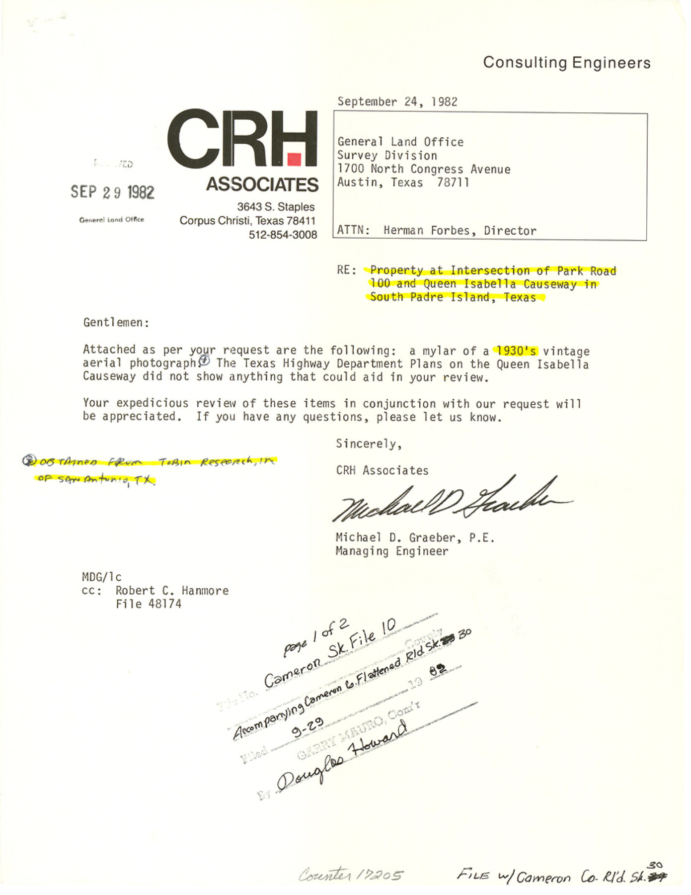
Cameron County Sketch File 10
[Letter regarding property at intersection of Park Road 100 and Queen Isabella Causeway in South Padre Island]
-
Map/Doc
17205
-
Collection
General Map Collection
-
Object Dates
1989/9/24 (Creation Date)
1989/9/29 (File Date)
-
People and Organizations
Michael D. Graeber (Surveyor/Engineer)
-
Counties
Cameron
-
Subjects
Surveying Sketch File
-
Height x Width
11.1 x 8.6 inches
28.2 x 21.8 cm
-
Medium
paper, print
-
Comments
See Cameron County Rolled Sketch 30 (5394) for aerial photograph.
-
Features
Park Road 100
Queen Isabella Causeway
South Padre Island
Gulf of Mexico
Padre Island
Isla Blanca
North Jetty
Brazos Santiago Pass
Isla Blanca Park
Back Bay
South Jetty
Ship Channel
U.S. Coast Guard Station
Related maps
Cameron County Rolled Sketch 30

Print $20.00
- Digital $50.00
Cameron County Rolled Sketch 30
1930
Size 36.3 x 24.4 inches
Map/Doc 5394
Part of: General Map Collection
Aransas County Rolled Sketch 2

Print $40.00
- Digital $50.00
Aransas County Rolled Sketch 2
1950
Size 54.7 x 50.5 inches
Map/Doc 73612
Nacogdoches County Working Sketch 4

Print $20.00
- Digital $50.00
Nacogdoches County Working Sketch 4
1946
Size 22.2 x 23.2 inches
Map/Doc 71220
Limestone County Working Sketch 17

Print $20.00
- Digital $50.00
Limestone County Working Sketch 17
1959
Size 42.2 x 33.1 inches
Map/Doc 70567
Railroad Track Map, T&PRRCo., Culberson County, Texas

Print $4.00
- Digital $50.00
Railroad Track Map, T&PRRCo., Culberson County, Texas
1910
Size 11.7 x 18.6 inches
Map/Doc 62829
Township No. 7 South Range No. 4 West of the Indian Meridian, Chickasaw Lands

Print $4.00
- Digital $50.00
Township No. 7 South Range No. 4 West of the Indian Meridian, Chickasaw Lands
1871
Size 18.2 x 22.4 inches
Map/Doc 75146
Chambers County Sketch File 48

Print $88.00
- Digital $50.00
Chambers County Sketch File 48
1925
Size 14.3 x 8.8 inches
Map/Doc 18002
Brewster County Sketch File N-23

Print $6.00
- Digital $50.00
Brewster County Sketch File N-23
1951
Size 14.4 x 9.0 inches
Map/Doc 15697
Montgomery County Working Sketch 17

Print $20.00
- Digital $50.00
Montgomery County Working Sketch 17
1934
Size 39.0 x 36.9 inches
Map/Doc 71124
Lampasas County Sketch File 2

Print $40.00
- Digital $50.00
Lampasas County Sketch File 2
1858
Size 15.6 x 12.7 inches
Map/Doc 29390
Starr County Sketch File 20a

Print $12.00
- Digital $50.00
Starr County Sketch File 20a
1892
Size 14.3 x 8.8 inches
Map/Doc 36883
Flight Mission No. DAG-17K, Frame 123, Matagorda County

Print $20.00
- Digital $50.00
Flight Mission No. DAG-17K, Frame 123, Matagorda County
1952
Size 18.6 x 22.3 inches
Map/Doc 86343
Washington County Working Sketch 1

Print $20.00
- Digital $50.00
Washington County Working Sketch 1
1957
Size 25.1 x 25.4 inches
Map/Doc 72362
You may also like
Working Sketch Patents & Field Notes, Sabine Lake Area

Print $20.00
- Digital $50.00
Working Sketch Patents & Field Notes, Sabine Lake Area
1959
Size 30.2 x 27.0 inches
Map/Doc 2455
Winkler County Working Sketch Graphic Index

Print $20.00
- Digital $50.00
Winkler County Working Sketch Graphic Index
1932
Size 36.4 x 36.4 inches
Map/Doc 76744
Controlled Mosaic by Jack Amman Photogrammetric Engineers, Inc - Sheet 10

Print $20.00
- Digital $50.00
Controlled Mosaic by Jack Amman Photogrammetric Engineers, Inc - Sheet 10
1954
Size 20.0 x 24.0 inches
Map/Doc 83454
Montgomery County Sketch File 21

Print $8.00
- Digital $50.00
Montgomery County Sketch File 21
1934
Size 9.0 x 13.2 inches
Map/Doc 31856
Jefferson Co.

Print $40.00
- Digital $50.00
Jefferson Co.
1978
Size 48.2 x 42.7 inches
Map/Doc 73196
Atascosa County Sketch File 15a

Print $5.00
- Digital $50.00
Atascosa County Sketch File 15a
1879
Size 17.4 x 8.2 inches
Map/Doc 13777
Packery Channel

Print $3.00
- Digital $50.00
Packery Channel
1962
Size 10.6 x 12.8 inches
Map/Doc 3006
Tom Green County Sketch File 50

Print $20.00
- Digital $50.00
Tom Green County Sketch File 50
1884
Size 25.4 x 34.5 inches
Map/Doc 12442
Flight Mission No. CRC-4R, Frame 185, Chambers County

Print $20.00
- Digital $50.00
Flight Mission No. CRC-4R, Frame 185, Chambers County
1956
Size 18.5 x 22.2 inches
Map/Doc 84936
McCulloch County Rolled Sketch 11

Print $20.00
- Digital $50.00
McCulloch County Rolled Sketch 11
1992
Size 46.3 x 40.3 inches
Map/Doc 9499
General Highway Map. Detail of Cities and Towns in Travis County, Texas. City Map, Austin and vicinity, Travis County, Texas

Print $20.00
General Highway Map. Detail of Cities and Towns in Travis County, Texas. City Map, Austin and vicinity, Travis County, Texas
1961
Size 18.1 x 24.7 inches
Map/Doc 79687
Wichita County Working Sketch 15

Print $20.00
- Digital $50.00
Wichita County Working Sketch 15
1919
Size 29.9 x 38.5 inches
Map/Doc 72525