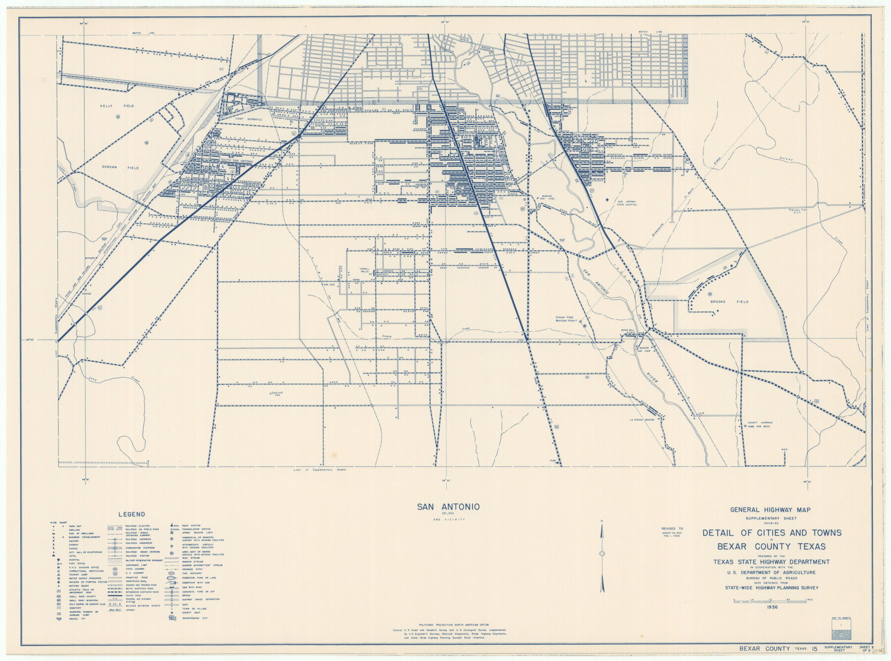
General Highway Map Supplementary Sheet Showing Detail of Cities and Towns in Bexar County Texas
-
Map/Doc
76290
-
Collection
Texas State Library and Archives
-
Object Dates
1936 (Creation Date)
-
People and Organizations
Texas State Highway Department (Publisher)
-
Counties
Bexar
-
Subjects
City County
-
Height x Width
18.5 x 25.0 inches
47.0 x 63.5 cm
-
Comments
Prints available courtesy of the Texas State Library and Archives.
More info can be found here: TSLAC Map 04796
Part of: Texas State Library and Archives
General Highway Map, Throckmorton County, Texas

Print $20.00
General Highway Map, Throckmorton County, Texas
1961
Size 18.2 x 24.8 inches
Map/Doc 79676
Map of the Country Upon Upper Red River Explored in 1852

Print $20.00
Map of the Country Upon Upper Red River Explored in 1852
1852
Size 17.2 x 34.9 inches
Map/Doc 79726
General Highway Map, Jasper County, Texas

Print $20.00
General Highway Map, Jasper County, Texas
1961
Size 18.2 x 24.8 inches
Map/Doc 79534
Mexico and Internal Provinces

Print $20.00
Mexico and Internal Provinces
1829
Size 12.9 x 14.5 inches
Map/Doc 79733
General Highway Map, Armstrong County, Texas

Print $20.00
General Highway Map, Armstrong County, Texas
1940
Size 18.1 x 25.0 inches
Map/Doc 79006
General Highway Map, Bell County, Texas

Print $20.00
General Highway Map, Bell County, Texas
1961
Size 18.3 x 25.1 inches
Map/Doc 79366
[Town Plat of Galveston]
![76258, [Town Plat of Galveston], Texas State Library and Archives](https://historictexasmaps.com/wmedia_w700/maps/76258.tif.jpg)
Print $20.00
[Town Plat of Galveston]
1877
Size 9.1 x 14.5 inches
Map/Doc 76258
General Highway Map. Detail of Cities and Towns in Taylor County, Texas [Abilene and vicinity]
![79255, General Highway Map. Detail of Cities and Towns in Taylor County, Texas [Abilene and vicinity], Texas State Library and Archives](https://historictexasmaps.com/wmedia_w700/maps/79255.tif.jpg)
Print $20.00
General Highway Map. Detail of Cities and Towns in Taylor County, Texas [Abilene and vicinity]
1940
Size 18.5 x 24.9 inches
Map/Doc 79255
General Highway Map, Polk County, Texas

Print $20.00
General Highway Map, Polk County, Texas
1961
Size 18.2 x 24.4 inches
Map/Doc 79629
General Highway Map, Austin County, Texas

Print $20.00
General Highway Map, Austin County, Texas
1939
Size 18.4 x 25.0 inches
Map/Doc 79009
General Highway Map. Detail of Cities and Towns in Dallas County, Texas [Dallas and vicinity]
![79070, General Highway Map. Detail of Cities and Towns in Dallas County, Texas [Dallas and vicinity], Texas State Library and Archives](https://historictexasmaps.com/wmedia_w700/maps/79070.tif.jpg)
Print $20.00
General Highway Map. Detail of Cities and Towns in Dallas County, Texas [Dallas and vicinity]
1936
Size 18.4 x 25.1 inches
Map/Doc 79070
General Highway Map, Tyler County, Texas

Print $20.00
General Highway Map, Tyler County, Texas
1961
Size 24.8 x 18.1 inches
Map/Doc 79690
You may also like
Flight Mission No. DCL-7C, Frame 123, Kenedy County

Print $20.00
- Digital $50.00
Flight Mission No. DCL-7C, Frame 123, Kenedy County
1943
Size 18.5 x 22.2 inches
Map/Doc 86088
The Judicial District/County of Smith. Created, February 1, 1842

Print $20.00
The Judicial District/County of Smith. Created, February 1, 1842
2020
Size 19.6 x 21.7 inches
Map/Doc 96346
Polk County Working Sketch 33b

Print $20.00
- Digital $50.00
Polk County Working Sketch 33b
1960
Size 14.9 x 24.8 inches
Map/Doc 71650
Flight Mission No. DQO-8K, Frame 113, Galveston County

Print $20.00
- Digital $50.00
Flight Mission No. DQO-8K, Frame 113, Galveston County
1952
Size 18.6 x 22.5 inches
Map/Doc 85195
Willacy County

Print $20.00
- Digital $50.00
Willacy County
1921
Size 23.5 x 31.0 inches
Map/Doc 77459
Bosque County

Print $40.00
- Digital $50.00
Bosque County
1945
Size 48.3 x 38.0 inches
Map/Doc 73083
Abandoned and Canceled Surveys - Volume 3 of 3, Counties L-Z

Abandoned and Canceled Surveys - Volume 3 of 3, Counties L-Z
Map/Doc 83250
Archer County Sketch File 19

Print $40.00
- Digital $50.00
Archer County Sketch File 19
1902
Size 23.8 x 26.8 inches
Map/Doc 10829
Dimmit County Working Sketch 12

Print $20.00
- Digital $50.00
Dimmit County Working Sketch 12
1941
Size 14.4 x 16.3 inches
Map/Doc 68673
Midland County

Print $20.00
- Digital $50.00
Midland County
1901
Size 43.7 x 40.3 inches
Map/Doc 66929
Gaines County Rolled Sketch 35

Print $20.00
- Digital $50.00
Gaines County Rolled Sketch 35
2014
Size 18.7 x 25.9 inches
Map/Doc 93695
Kleberg County Sketch File 2

Print $5.00
- Digital $50.00
Kleberg County Sketch File 2
1934
Size 11.1 x 8.8 inches
Map/Doc 29210