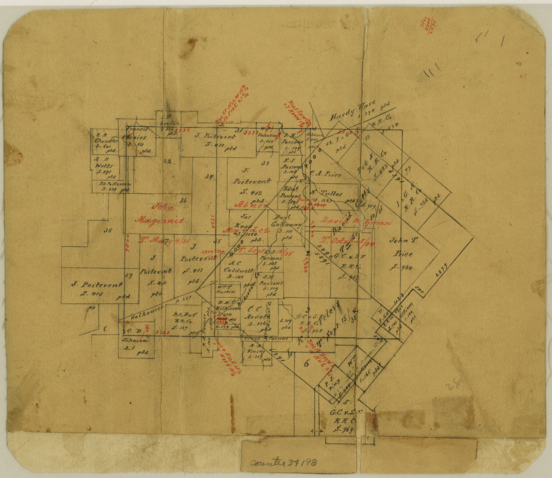
Polk County Sketch File 28
[Office sketch showing surveys in conflict with L. K. Peters and D. Cutts]
-
Map/Doc
34198
-
Collection
General Map Collection
-
People and Organizations
Pressler (Surveyor/Engineer)
-
Counties
Polk
-
Subjects
Surveying Sketch File
-
Height x Width
8.6 x 9.9 inches
21.8 x 25.1 cm
-
Medium
paper, manuscript
-
Features
Dickerson Creek
Part of: General Map Collection
Flight Mission No. CRC-3R, Frame 197, Chambers County

Print $20.00
- Digital $50.00
Flight Mission No. CRC-3R, Frame 197, Chambers County
1956
Size 18.5 x 22.3 inches
Map/Doc 84852
Fort Bend County Sketch File 3a

Print $6.00
- Digital $50.00
Fort Bend County Sketch File 3a
1874
Size 8.3 x 8.0 inches
Map/Doc 22882
Terry County Rolled Sketch 4

Print $20.00
- Digital $50.00
Terry County Rolled Sketch 4
Size 38.7 x 36.8 inches
Map/Doc 9994
Pecos County Working Sketch 130

Print $20.00
- Digital $50.00
Pecos County Working Sketch 130
1976
Size 27.6 x 36.5 inches
Map/Doc 71604
Upton County Working Sketch 12

Print $40.00
- Digital $50.00
Upton County Working Sketch 12
1937
Size 43.6 x 77.9 inches
Map/Doc 69508
Mills County Working Sketch 7

Print $20.00
- Digital $50.00
Mills County Working Sketch 7
1914
Size 12.8 x 13.0 inches
Map/Doc 71037
Right of Way and Track Map, the Missouri, Kansas and Texas Ry. of Texas - Henrietta Division

Print $20.00
- Digital $50.00
Right of Way and Track Map, the Missouri, Kansas and Texas Ry. of Texas - Henrietta Division
1918
Size 11.8 x 26.8 inches
Map/Doc 64755
Ochiltree County Boundary File 7

Print $20.00
- Digital $50.00
Ochiltree County Boundary File 7
Size 36.1 x 9.3 inches
Map/Doc 57715
Sterling County Rolled Sketch 38

Print $20.00
- Digital $50.00
Sterling County Rolled Sketch 38
1988
Size 25.0 x 31.7 inches
Map/Doc 7863
Pecos County Sketch File 89

Print $40.00
- Digital $50.00
Pecos County Sketch File 89
1949
Size 15.2 x 12.2 inches
Map/Doc 33986
Sutton County Sketch File 14

Print $20.00
- Digital $50.00
Sutton County Sketch File 14
1924
Size 17.8 x 20.0 inches
Map/Doc 12380
Newton County Sketch File 9

Print $4.00
- Digital $50.00
Newton County Sketch File 9
Size 9.8 x 8.3 inches
Map/Doc 32378
You may also like
Jasper County Sketch File 3

Print $6.00
- Digital $50.00
Jasper County Sketch File 3
Size 10.1 x 15.2 inches
Map/Doc 27768
Harris County Rolled Sketch 88

Print $20.00
- Digital $50.00
Harris County Rolled Sketch 88
1935
Size 19.2 x 22.5 inches
Map/Doc 6123


Lavaca County Working Sketch 12

Print $20.00
- Digital $50.00
Lavaca County Working Sketch 12
1954
Size 17.3 x 32.4 inches
Map/Doc 70365
Kleberg County Working Sketch 1

Print $20.00
- Digital $50.00
Kleberg County Working Sketch 1
1925
Size 21.9 x 43.8 inches
Map/Doc 70242
Burleson County Working Sketch 4

Print $20.00
- Digital $50.00
Burleson County Working Sketch 4
1979
Size 33.3 x 35.6 inches
Map/Doc 67723
Coke County Rolled Sketch 13

Print $40.00
- Digital $50.00
Coke County Rolled Sketch 13
Size 44.5 x 69.9 inches
Map/Doc 8627
Edwards County Working Sketch 2

Print $20.00
- Digital $50.00
Edwards County Working Sketch 2
Size 13.6 x 19.0 inches
Map/Doc 68878
Parker County Sketch File 37

Print $4.00
- Digital $50.00
Parker County Sketch File 37
Size 4.8 x 8.1 inches
Map/Doc 33581
Culberson County Rolled Sketch 68

Print $20.00
- Digital $50.00
Culberson County Rolled Sketch 68
1997
Size 32.0 x 32.9 inches
Map/Doc 76402
Controlled Mosaic by Jack Amman Photogrammetric Engineers, Inc - Sheet 31

Print $20.00
- Digital $50.00
Controlled Mosaic by Jack Amman Photogrammetric Engineers, Inc - Sheet 31
1954
Size 20.0 x 24.0 inches
Map/Doc 83484