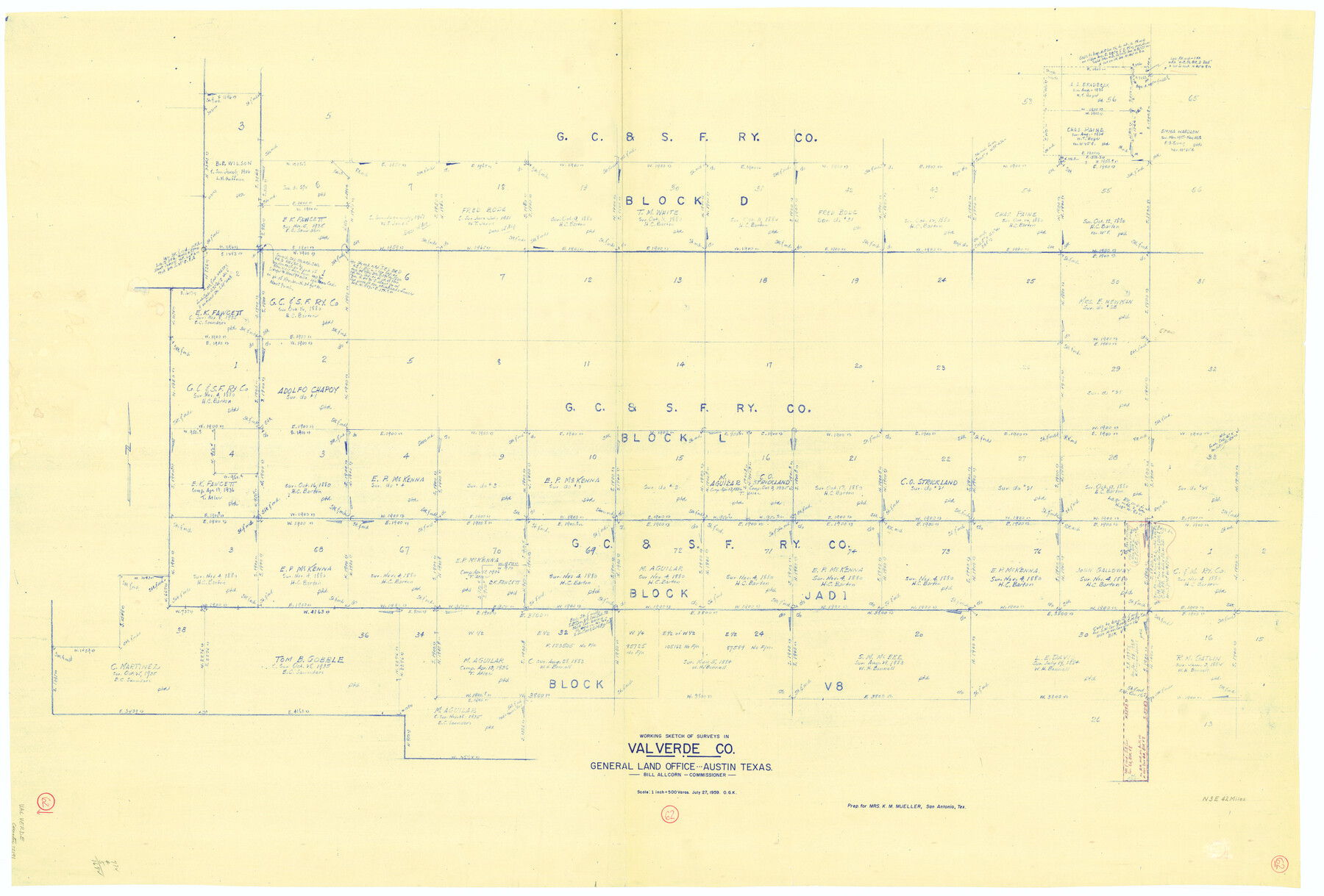
Val Verde County Working Sketch 62
-
Map/Doc
72197
-
Collection
General Map Collection
-
Object Dates
7/27/1959 (Creation Date)
-
People and Organizations
Otto G. Kurio (Draftsman)
-
Counties
Val Verde
-
Subjects
Surveying Working Sketch
-
Height x Width
38.3 x 56.6 inches
97.3 x 143.8 cm
-
Scale
1" = 500 varas
Part of: General Map Collection
Comal County Sketch File 6

Print $6.00
- Digital $50.00
Comal County Sketch File 6
Size 10.3 x 8.1 inches
Map/Doc 19008
Harris County Sketch File 23

Print $4.00
- Digital $50.00
Harris County Sketch File 23
Size 8.5 x 6.2 inches
Map/Doc 25377
[Galveston, Harrisburg & San Antonio Railroad from Cuero to Stockdale]
![64186, [Galveston, Harrisburg & San Antonio Railroad from Cuero to Stockdale], General Map Collection](https://historictexasmaps.com/wmedia_w700/maps/64186.tif.jpg)
Print $20.00
- Digital $50.00
[Galveston, Harrisburg & San Antonio Railroad from Cuero to Stockdale]
1906
Size 13.4 x 33.1 inches
Map/Doc 64186
Val Verde County Working Sketch 75

Print $40.00
- Digital $50.00
Val Verde County Working Sketch 75
1971
Size 31.4 x 49.2 inches
Map/Doc 72210
United States - Gulf Coast Texas - Southern part of Laguna Madre

Print $20.00
- Digital $50.00
United States - Gulf Coast Texas - Southern part of Laguna Madre
1941
Size 27.1 x 18.3 inches
Map/Doc 72954
Refugio County Rolled Sketch 4

Print $40.00
- Digital $50.00
Refugio County Rolled Sketch 4
1941
Size 55.7 x 46.4 inches
Map/Doc 9958
Van Zandt County Sketch File 38

Print $4.00
- Digital $50.00
Van Zandt County Sketch File 38
1871
Size 8.2 x 10.1 inches
Map/Doc 39482
Wilbarger County Boundary File 1b

Print $40.00
- Digital $50.00
Wilbarger County Boundary File 1b
Size 14.3 x 8.8 inches
Map/Doc 59943
San Patricio County Rolled Sketch 46E

Print $20.00
- Digital $50.00
San Patricio County Rolled Sketch 46E
1983
Size 17.4 x 46.3 inches
Map/Doc 8376
Presidio County Sketch File 85

Print $6.00
- Digital $50.00
Presidio County Sketch File 85
1950
Size 14.3 x 8.9 inches
Map/Doc 34745
Flight Mission No. BRA-16M, Frame 91, Jefferson County

Print $20.00
- Digital $50.00
Flight Mission No. BRA-16M, Frame 91, Jefferson County
1953
Size 18.7 x 22.5 inches
Map/Doc 85703
Frio County Sketch File 17

Print $6.00
- Digital $50.00
Frio County Sketch File 17
1955
Size 14.3 x 8.7 inches
Map/Doc 23152
You may also like
Jefferson County Rolled Sketch 25B

Print $20.00
- Digital $50.00
Jefferson County Rolled Sketch 25B
Size 23.2 x 28.3 inches
Map/Doc 6390
Map showing survey for proposed ship channel from Brownsville to Brazos Santiago Pass

Print $20.00
- Digital $50.00
Map showing survey for proposed ship channel from Brownsville to Brazos Santiago Pass
1912
Size 18.1 x 28.0 inches
Map/Doc 72899
Hutchinson County Sketch File 33

Print $20.00
- Digital $50.00
Hutchinson County Sketch File 33
1926
Size 26.5 x 24.5 inches
Map/Doc 11821
Upton County Rolled Sketch 43

Print $40.00
- Digital $50.00
Upton County Rolled Sketch 43
Size 27.1 x 54.2 inches
Map/Doc 10057
[Block C39, Sections 22, 23 Millican Estate, 24]
![92345, [Block C39, Sections 22, 23 Millican Estate, 24], Twichell Survey Records](https://historictexasmaps.com/wmedia_w700/maps/92345-1.tif.jpg)
Print $20.00
- Digital $50.00
[Block C39, Sections 22, 23 Millican Estate, 24]
1956
Size 11.4 x 31.2 inches
Map/Doc 92345
Map of Texas Compiled from surveys on record in the General Land Office of the Republic to the year 1839

Print $20.00
- Digital $50.00
Map of Texas Compiled from surveys on record in the General Land Office of the Republic to the year 1839
1891
Size 36.6 x 25.7 inches
Map/Doc 1891
Jefferson County, Texas

Print $20.00
- Digital $50.00
Jefferson County, Texas
1879
Size 21.7 x 18.8 inches
Map/Doc 521
Township 4 South Ranges 12 and 13 West, South Western District, Louisiana

Print $20.00
- Digital $50.00
Township 4 South Ranges 12 and 13 West, South Western District, Louisiana
1879
Size 18.3 x 24.1 inches
Map/Doc 65890
Shelby County

Print $40.00
- Digital $50.00
Shelby County
1897
Size 43.4 x 50.1 inches
Map/Doc 63033
Tom Green County Sketch File 35

Print $6.00
- Digital $50.00
Tom Green County Sketch File 35
Size 10.2 x 15.9 inches
Map/Doc 38192
Map of Fort Worth

Print $40.00
- Digital $50.00
Map of Fort Worth
1902
Size 61.3 x 34.8 inches
Map/Doc 93274
Original Town of Nadine, Lea County, New Mexico

Print $20.00
- Digital $50.00
Original Town of Nadine, Lea County, New Mexico
Size 27.1 x 33.5 inches
Map/Doc 92420