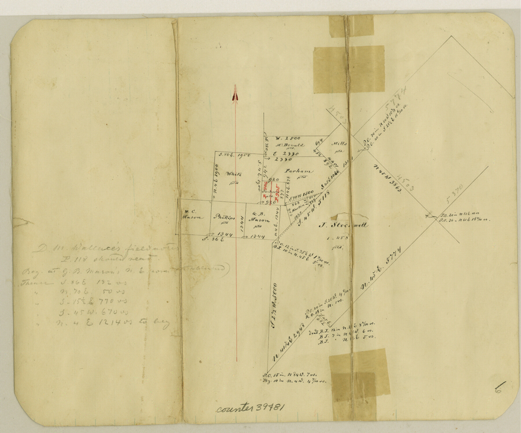
Van Zandt County Sketch File 38
[Office sketch of surveys around Canton]
-
Map/Doc
39482
-
Collection
General Map Collection
-
Object Dates
9/22/1871 (Creation Date)
-
People and Organizations
Thielepape (Draftsman)
-
Counties
Van Zandt
-
Subjects
Surveying Sketch File
-
Height x Width
8.2 x 10.1 inches
20.8 x 25.7 cm
-
Medium
paper, manuscript
Part of: General Map Collection
Brewster County Rolled Sketch 19A

Print $20.00
- Digital $50.00
Brewster County Rolled Sketch 19A
1881
Size 31.5 x 38.6 inches
Map/Doc 8471
Zapata County Working Sketch 22

Print $20.00
- Digital $50.00
Zapata County Working Sketch 22
1984
Size 31.8 x 40.1 inches
Map/Doc 62073
[Surveys in Austin's Colony along New Year's Creek and near the Brazos River]
![218, [Surveys in Austin's Colony along New Year's Creek and near the Brazos River], General Map Collection](https://historictexasmaps.com/wmedia_w700/maps/218.tif.jpg)
Print $20.00
- Digital $50.00
[Surveys in Austin's Colony along New Year's Creek and near the Brazos River]
1821
Size 17.4 x 14.9 inches
Map/Doc 218
Flight Mission No. CGI-4N, Frame 30, Cameron County

Print $20.00
- Digital $50.00
Flight Mission No. CGI-4N, Frame 30, Cameron County
1954
Size 18.6 x 22.3 inches
Map/Doc 84663
Lynn County Rolled Sketch 16

Print $20.00
- Digital $50.00
Lynn County Rolled Sketch 16
1991
Size 18.3 x 42.3 inches
Map/Doc 6652
Clay County Boundary File 8

Print $18.00
- Digital $50.00
Clay County Boundary File 8
Size 13.3 x 8.2 inches
Map/Doc 51384
Brazoria County Sketch File 9

Print $6.00
- Digital $50.00
Brazoria County Sketch File 9
Size 14.0 x 9.0 inches
Map/Doc 14936
King County Working Sketch 4

Print $20.00
- Digital $50.00
King County Working Sketch 4
1939
Size 42.9 x 25.7 inches
Map/Doc 70168
Menard County Sketch File 24

Print $20.00
- Digital $50.00
Menard County Sketch File 24
1932
Size 17.0 x 26.5 inches
Map/Doc 12077
Medina County Rolled Sketch 4

Print $20.00
- Digital $50.00
Medina County Rolled Sketch 4
1943
Size 20.2 x 26.4 inches
Map/Doc 6740
Crockett County Rolled Sketch 43

Print $40.00
- Digital $50.00
Crockett County Rolled Sketch 43
1937
Size 31.4 x 63.2 inches
Map/Doc 8708
Galveston County Rolled Sketch 11

Print $40.00
- Digital $50.00
Galveston County Rolled Sketch 11
1928
Size 29.7 x 169.5 inches
Map/Doc 9089
You may also like
Travis County Working Sketch 8

Print $20.00
- Digital $50.00
Travis County Working Sketch 8
1917
Size 18.8 x 18.8 inches
Map/Doc 69392
Knox County Rolled Sketch 26

Print $20.00
- Digital $50.00
Knox County Rolled Sketch 26
2007
Size 36.8 x 24.7 inches
Map/Doc 88822
Texas State Boundary Line 9

Print $174.00
Texas State Boundary Line 9
2000
Size 11.3 x 8.8 inches
Map/Doc 75076
La Salle County Sketch File 13a

Print $8.00
- Digital $50.00
La Salle County Sketch File 13a
1878
Size 12.7 x 8.0 inches
Map/Doc 29479
Wichita County Working Sketch 10

Print $20.00
- Digital $50.00
Wichita County Working Sketch 10
1920
Size 25.4 x 16.1 inches
Map/Doc 72519
Flight Mission No. DQN-5K, Frame 51, Calhoun County

Print $20.00
- Digital $50.00
Flight Mission No. DQN-5K, Frame 51, Calhoun County
1953
Size 18.6 x 22.2 inches
Map/Doc 84396
Rockwall County Boundary File 76

Print $14.00
- Digital $50.00
Rockwall County Boundary File 76
Size 11.4 x 8.9 inches
Map/Doc 58497
Knox County Sketch File 22

Print $6.00
- Digital $50.00
Knox County Sketch File 22
1931
Size 11.2 x 8.8 inches
Map/Doc 29251
Pass Cavallo, Entrance to Matagorda Bay, Texas

Print $20.00
- Digital $50.00
Pass Cavallo, Entrance to Matagorda Bay, Texas
1882
Size 24.3 x 18.7 inches
Map/Doc 73375
Gregg County Sketch File 4a

Print $4.00
- Digital $50.00
Gregg County Sketch File 4a
1848
Size 12.7 x 8.1 inches
Map/Doc 24572
Houston County Working Sketch 14

Print $20.00
- Digital $50.00
Houston County Working Sketch 14
1957
Size 35.1 x 24.0 inches
Map/Doc 66244
Nueces County Sketch File 1

Print $24.00
- Digital $50.00
Nueces County Sketch File 1
1847
Size 7.6 x 12.5 inches
Map/Doc 32497