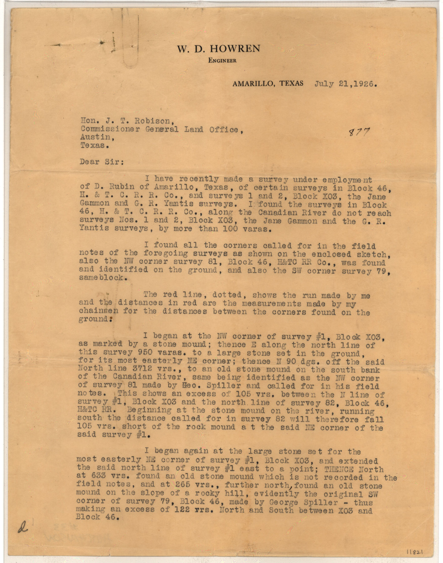
Hutchinson County Sketch File 33
W. D. Howren's sk. Of surs. In Blks. 46, X03, etc. South of Canadian River
-
Map/Doc
11821
-
Collection
General Map Collection
-
Object Dates
7/21/1926 (Creation Date)
7/26/1926 (File Date)
7/21/1926 (Correspondence Date)
7/1926 (Survey Date)
-
People and Organizations
W.D. Howren (Surveyor/Engineer)
George Spiller (Surveyor/Engineer)
W.D. Twichell (Surveyor/Engineer)
W.D. Howren (Draftsman)
-
Counties
Hutchinson
-
Subjects
Surveying Sketch File
-
Height x Width
26.5 x 24.5 inches
67.3 x 62.2 cm
-
Medium
multi-page, multi-format
-
Scale
1:500
-
Features
Canadian River
Part of: General Map Collection
Dallam County Sketch File 16

Print $28.00
- Digital $50.00
Dallam County Sketch File 16
1993
Size 11.5 x 8.7 inches
Map/Doc 20390
America Settentrionale colle nuove scoperte fin all’anno 1688

Print $20.00
- Digital $50.00
America Settentrionale colle nuove scoperte fin all’anno 1688
1688
Size 29.7 x 37.5 inches
Map/Doc 93709
Pecos County Working Sketch Graphic Index - northeast part - sheet A

Print $20.00
- Digital $50.00
Pecos County Working Sketch Graphic Index - northeast part - sheet A
1975
Size 35.8 x 42.6 inches
Map/Doc 76666
Terrell County Working Sketch 24

Print $20.00
- Digital $50.00
Terrell County Working Sketch 24
1942
Size 16.2 x 41.3 inches
Map/Doc 62174
Map showing lands acquired for reservoir purposes in connection with Lake Worth and the boundary of territory annexed to the City of Fort Worth, Texas

Print $40.00
- Digital $50.00
Map showing lands acquired for reservoir purposes in connection with Lake Worth and the boundary of territory annexed to the City of Fort Worth, Texas
Size 46.6 x 59.6 inches
Map/Doc 62210
Duval County Working Sketch 28

Print $20.00
- Digital $50.00
Duval County Working Sketch 28
1948
Size 29.7 x 37.4 inches
Map/Doc 68752
Flight Mission No. DQO-8K, Frame 84, Galveston County

Print $20.00
- Digital $50.00
Flight Mission No. DQO-8K, Frame 84, Galveston County
1952
Size 18.6 x 22.5 inches
Map/Doc 85186
Shelby County Working Sketch 19

Print $20.00
- Digital $50.00
Shelby County Working Sketch 19
1969
Size 36.9 x 30.2 inches
Map/Doc 63872
Wheeler County Boundary File 1c

Print $4.00
- Digital $50.00
Wheeler County Boundary File 1c
Size 11.4 x 8.9 inches
Map/Doc 59870
Flight Mission No. DQN-2K, Frame 33, Calhoun County

Print $20.00
- Digital $50.00
Flight Mission No. DQN-2K, Frame 33, Calhoun County
1953
Size 18.6 x 22.2 inches
Map/Doc 84240
Current Miscellaneous File 92

Print $22.00
- Digital $50.00
Current Miscellaneous File 92
1990
Size 11.2 x 8.8 inches
Map/Doc 74265
Johnson County Sketch File 10

Print $4.00
- Digital $50.00
Johnson County Sketch File 10
1859
Size 10.1 x 8.0 inches
Map/Doc 28443
You may also like
Calcasieu Pass to Sabine Pass
Print $20.00
- Digital $50.00
Calcasieu Pass to Sabine Pass
1973
Size 44.8 x 35.6 inches
Map/Doc 69812
Polk County Sketch File 29a

Print $4.00
- Digital $50.00
Polk County Sketch File 29a
Size 12.1 x 8.2 inches
Map/Doc 34202
Montgomery County Rolled Sketch 10A
Print $20.00
- Digital $50.00
Montgomery County Rolled Sketch 10A
Size 12.1 x 18.1 inches
Map/Doc 6800
Uvalde County Rolled Sketch 9

Print $20.00
- Digital $50.00
Uvalde County Rolled Sketch 9
1924
Size 16.6 x 24.6 inches
Map/Doc 8094
Reeves County Sketch File 9

Print $20.00
- Digital $50.00
Reeves County Sketch File 9
Size 46.3 x 38.2 inches
Map/Doc 10587
Flight Mission No. CUG-3P, Frame 24, Kleberg County

Print $20.00
- Digital $50.00
Flight Mission No. CUG-3P, Frame 24, Kleberg County
1956
Size 18.4 x 22.3 inches
Map/Doc 86234
Wilbarger Co.

Print $40.00
- Digital $50.00
Wilbarger Co.
1907
Size 48.8 x 39.8 inches
Map/Doc 63127
Hutchinson County Sketch File 38

Print $40.00
- Digital $50.00
Hutchinson County Sketch File 38
1935
Size 17.6 x 14.2 inches
Map/Doc 27280
Eastland County Working Sketch 18

Print $20.00
- Digital $50.00
Eastland County Working Sketch 18
1919
Size 15.9 x 15.7 inches
Map/Doc 68799
[Sketch of T.&P. Blocks 31-34, Tsp. 3N & 4N]
![89746, [Sketch of T.&P. Blocks 31-34, Tsp. 3N & 4N], Twichell Survey Records](https://historictexasmaps.com/wmedia_w700/maps/89746-1.tif.jpg)
Print $20.00
- Digital $50.00
[Sketch of T.&P. Blocks 31-34, Tsp. 3N & 4N]
Size 42.9 x 32.2 inches
Map/Doc 89746
Jim Wells Co.

Print $20.00
- Digital $50.00
Jim Wells Co.
1966
Size 42.7 x 31.0 inches
Map/Doc 73198
Zavala County Working Sketch 24

Print $40.00
- Digital $50.00
Zavala County Working Sketch 24
1980
Size 75.6 x 42.8 inches
Map/Doc 62099