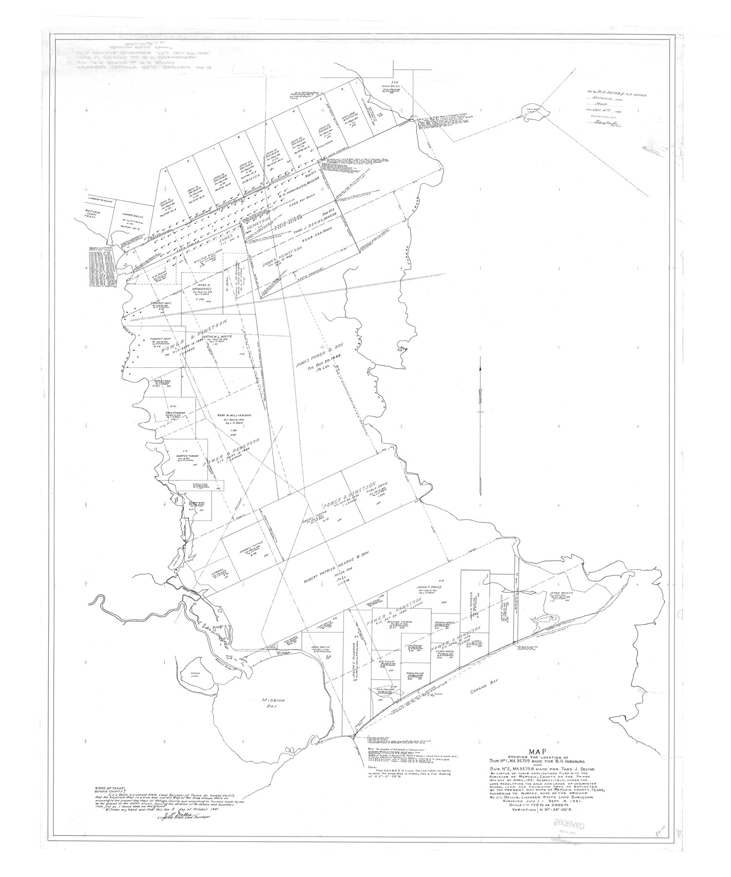
Refugio County Rolled Sketch 4
Map showing the location of sur. no. 1, MA-35759 made for B.H. Hornburg and sur. no. 2, MA-35758 made for Thos. J. Devine
-
Map/Doc
9958
-
Collection
General Map Collection
-
Object Dates
1941/10/4 (File Date)
1941/9/6 (Survey Date)
1941/10/3 (Creation Date)
-
People and Organizations
J.L. Dellis (Surveyor/Engineer)
-
Counties
Refugio
-
Subjects
Surveying Rolled Sketch
-
Height x Width
55.7 x 46.4 inches
141.5 x 117.9 cm
-
Scale
1" = 720 varas
Part of: General Map Collection
Terrell County Working Sketch 61

Print $20.00
- Digital $50.00
Terrell County Working Sketch 61
1962
Size 20.3 x 34.3 inches
Map/Doc 69582
Crane County Sketch File 3

Print $20.00
- Digital $50.00
Crane County Sketch File 3
Size 23.6 x 26.0 inches
Map/Doc 11204
Presidio County Rolled Sketch 80A

Print $20.00
- Digital $50.00
Presidio County Rolled Sketch 80A
Size 26.9 x 28.9 inches
Map/Doc 7367
Pecos County Working Sketch 114

Print $40.00
- Digital $50.00
Pecos County Working Sketch 114
1972
Size 75.7 x 38.0 inches
Map/Doc 71587
Fisher County Sketch File 9

Print $4.00
- Digital $50.00
Fisher County Sketch File 9
1893
Size 11.1 x 8.5 inches
Map/Doc 22575
Coleman County Sketch File 9

Print $24.00
- Digital $50.00
Coleman County Sketch File 9
1859
Size 12.4 x 8.2 inches
Map/Doc 18675
Flight Mission No. DQO-7K, Frame 106, Galveston County

Print $20.00
- Digital $50.00
Flight Mission No. DQO-7K, Frame 106, Galveston County
1952
Size 18.5 x 22.6 inches
Map/Doc 85121
Calhoun County Boundary File 5

Print $10.00
- Digital $50.00
Calhoun County Boundary File 5
Size 14.2 x 8.8 inches
Map/Doc 51009
Kleberg County NRC Article 33.136 Sketch 1

Print $143.00
- Digital $50.00
Kleberg County NRC Article 33.136 Sketch 1
2000
Size 18.5 x 23.6 inches
Map/Doc 6555
Mitchell County Boundary File 66a

Print $11.00
- Digital $50.00
Mitchell County Boundary File 66a
Size 12.6 x 8.3 inches
Map/Doc 57378
Upton County Working Sketch 37

Print $20.00
- Digital $50.00
Upton County Working Sketch 37
1957
Size 41.1 x 36.9 inches
Map/Doc 69533
Ellis County Sketch File 9

Print $40.00
- Digital $50.00
Ellis County Sketch File 9
1860
Size 16.0 x 13.0 inches
Map/Doc 21843
You may also like
Karnes County Sketch File 5

Print $7.00
- Digital $50.00
Karnes County Sketch File 5
1849
Size 8.1 x 10.0 inches
Map/Doc 28554
Lamar County State Real Property Sketch 1

Print $20.00
- Digital $50.00
Lamar County State Real Property Sketch 1
2013
Size 24.0 x 36.0 inches
Map/Doc 93659
Henderson County Working Sketch 8

Print $20.00
- Digital $50.00
Henderson County Working Sketch 8
1922
Size 15.9 x 16.1 inches
Map/Doc 66141
General Highway Map, Val Verde County, Texas

Print $20.00
General Highway Map, Val Verde County, Texas
1961
Size 24.9 x 18.1 inches
Map/Doc 79694
Flight Mission No. DCL-7C, Frame 135, Kenedy County

Print $20.00
- Digital $50.00
Flight Mission No. DCL-7C, Frame 135, Kenedy County
1943
Size 15.5 x 15.3 inches
Map/Doc 86092
Interfaith's Official Map: The Woodlands, a real hometown for people and companies

Interfaith's Official Map: The Woodlands, a real hometown for people and companies
1997
Size 36.7 x 22.5 inches
Map/Doc 94285
Flight Mission No. DIX-6P, Frame 120, Aransas County

Print $20.00
- Digital $50.00
Flight Mission No. DIX-6P, Frame 120, Aransas County
1956
Size 18.7 x 22.2 inches
Map/Doc 83826
Treaty to Resolve Pending Boundary Differences and Maintain the Rio Grande and Colorado River as the International Boundary Between the United States of American and Mexico

Print $20.00
- Digital $50.00
Treaty to Resolve Pending Boundary Differences and Maintain the Rio Grande and Colorado River as the International Boundary Between the United States of American and Mexico
1970
Size 11.1 x 35.8 inches
Map/Doc 83102
Red River County Red River District

Print $20.00
- Digital $50.00
Red River County Red River District
1879
Size 24.9 x 21.8 inches
Map/Doc 3976
Brown County Sketch File 10a

Print $6.00
- Digital $50.00
Brown County Sketch File 10a
Size 11.2 x 9.8 inches
Map/Doc 16595
General Highway Map, Bell County, Texas

Print $20.00
General Highway Map, Bell County, Texas
1961
Size 18.3 x 25.1 inches
Map/Doc 79366
Castro County Sketch File 6

Print $20.00
- Digital $50.00
Castro County Sketch File 6
Size 20.8 x 15.6 inches
Map/Doc 11059