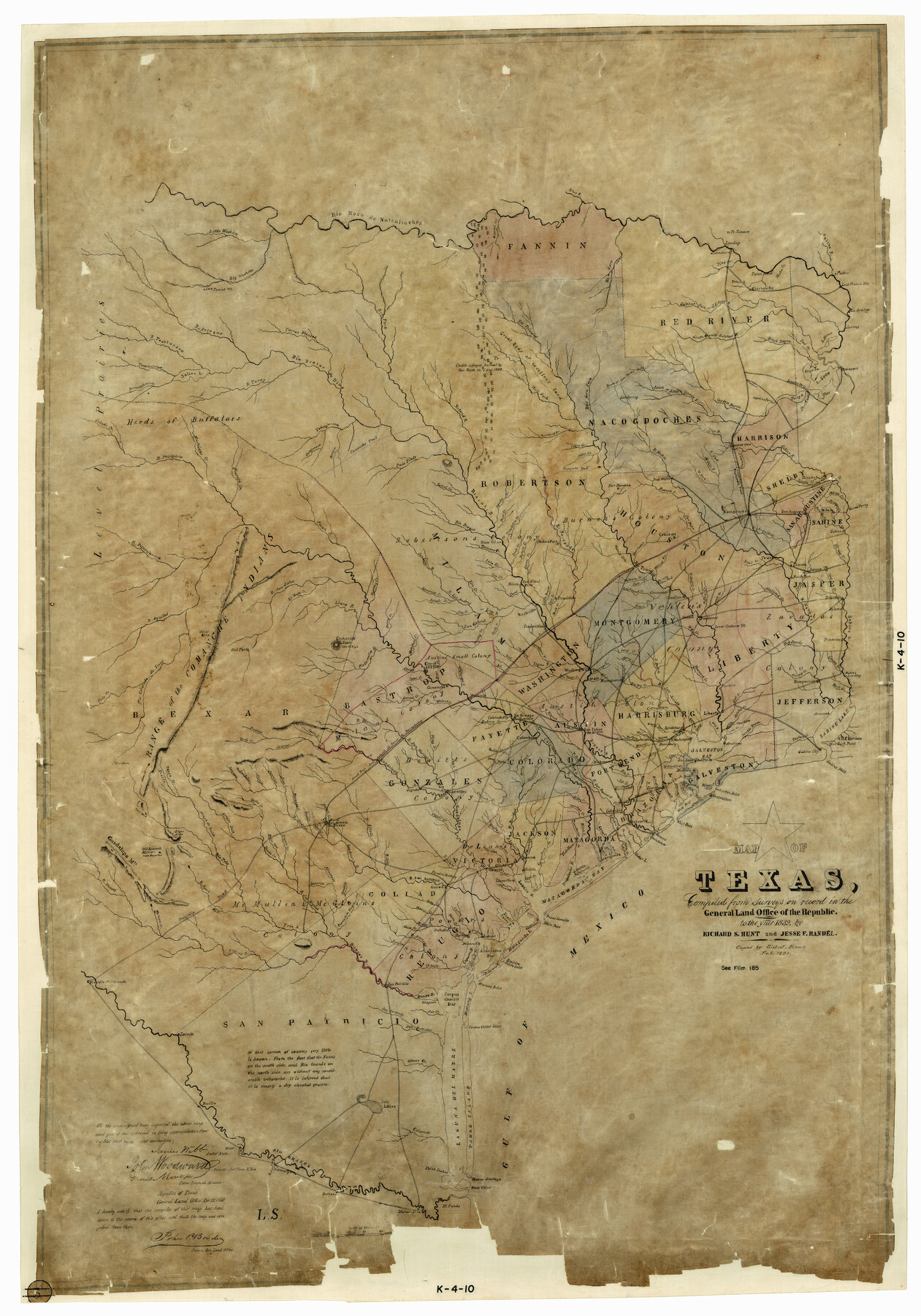
Map of Texas Compiled from surveys on record in the General Land Office of the Republic to the year 1839
K-4-10
-
Map/Doc
1891
-
Collection
General Map Collection
-
Object Dates
1891 (Creation Date)
-
People and Organizations
Sid. J. Rowe (Tracer)
Jesse F. Randel (Compiler)
Richard S. Hunt (Compiler)
-
Subjects
Republic of Texas
-
Height x Width
36.6 x 25.7 inches
93.0 x 65.3 cm
-
Comments
Facsimile tracing, copied in 1891.
Part of: General Map Collection
Edwards County Working Sketch 22

Print $20.00
- Digital $50.00
Edwards County Working Sketch 22
1938
Size 15.3 x 18.5 inches
Map/Doc 68898
Map of Kyle, Lockhart & Southern Ry.

Print $40.00
- Digital $50.00
Map of Kyle, Lockhart & Southern Ry.
1882
Size 14.5 x 94.9 inches
Map/Doc 64285
Aransas County Sketch File 24a

Print $42.00
- Digital $50.00
Aransas County Sketch File 24a
1941
Size 11.6 x 8.6 inches
Map/Doc 13195
Bandera County Sketch File 20

Print $40.00
- Digital $50.00
Bandera County Sketch File 20
Size 18.7 x 13.6 inches
Map/Doc 10894
Foard County Sketch File 32

Print $4.00
- Digital $50.00
Foard County Sketch File 32
1950
Size 14.5 x 9.0 inches
Map/Doc 22864
Karnes County Sketch File 12

Print $14.00
- Digital $50.00
Karnes County Sketch File 12
1889
Size 12.7 x 8.0 inches
Map/Doc 28604
Reeves County Rolled Sketch 8

Print $40.00
- Digital $50.00
Reeves County Rolled Sketch 8
Size 22.6 x 64.6 inches
Map/Doc 9848
Map of Sabine County

Print $20.00
- Digital $50.00
Map of Sabine County
1896
Size 26.6 x 19.3 inches
Map/Doc 4010
Kinney County Working Sketch 6

Print $20.00
- Digital $50.00
Kinney County Working Sketch 6
1908
Size 19.6 x 23.9 inches
Map/Doc 70188
Liberty County Sketch File 33a

Print $4.00
- Digital $50.00
Liberty County Sketch File 33a
1874
Size 7.9 x 8.2 inches
Map/Doc 29969
Brooks County Working Sketch 1

Print $3.00
- Digital $50.00
Brooks County Working Sketch 1
Size 9.1 x 9.3 inches
Map/Doc 67785
Crockett County

Print $40.00
- Digital $50.00
Crockett County
1882
Size 57.1 x 67.6 inches
Map/Doc 82212
You may also like
Through Storyland to Sunset Seas

Through Storyland to Sunset Seas
1895
Size 8.9 x 6.7 inches
Map/Doc 96606
Dawson County

Print $20.00
- Digital $50.00
Dawson County
1959
Size 43.1 x 35.1 inches
Map/Doc 95476
Marion County Working Sketch 38

Print $20.00
- Digital $50.00
Marion County Working Sketch 38
1991
Size 35.5 x 39.9 inches
Map/Doc 70814
[Office Sketch of Jesse McGee survey in Sabine and Newton Counties]
![543, [Office Sketch of Jesse McGee survey in Sabine and Newton Counties], Maddox Collection](https://historictexasmaps.com/wmedia_w700/maps/543.tif.jpg)
Print $20.00
- Digital $50.00
[Office Sketch of Jesse McGee survey in Sabine and Newton Counties]
1910
Size 13.4 x 15.1 inches
Map/Doc 543
College Park Addition to the City of Lubbock Located on Section 9, Block B

Print $20.00
- Digital $50.00
College Park Addition to the City of Lubbock Located on Section 9, Block B
Size 12.9 x 15.9 inches
Map/Doc 92277
General Highway Map, Galveston County, Texas

Print $20.00
General Highway Map, Galveston County, Texas
1961
Size 18.2 x 24.6 inches
Map/Doc 79476
General Highway Map, Coke County, Texas

Print $20.00
General Highway Map, Coke County, Texas
1940
Size 18.4 x 25.2 inches
Map/Doc 79049
Flight Mission No. DQN-7K, Frame 8, Calhoun County

Print $20.00
- Digital $50.00
Flight Mission No. DQN-7K, Frame 8, Calhoun County
1953
Size 18.5 x 22.2 inches
Map/Doc 84459
Kerr County Working Sketch 27

Print $20.00
- Digital $50.00
Kerr County Working Sketch 27
1970
Size 25.4 x 20.8 inches
Map/Doc 70058
Flight Mission No. DQN-2K, Frame 144, Calhoun County

Print $20.00
- Digital $50.00
Flight Mission No. DQN-2K, Frame 144, Calhoun County
1953
Size 18.7 x 22.4 inches
Map/Doc 84313
Navarro County Sketch File 3

Print $8.00
- Digital $50.00
Navarro County Sketch File 3
1847
Size 10.2 x 8.1 inches
Map/Doc 32300
McMullen County Working Sketch 31

Print $20.00
- Digital $50.00
McMullen County Working Sketch 31
1957
Size 39.9 x 25.9 inches
Map/Doc 70732