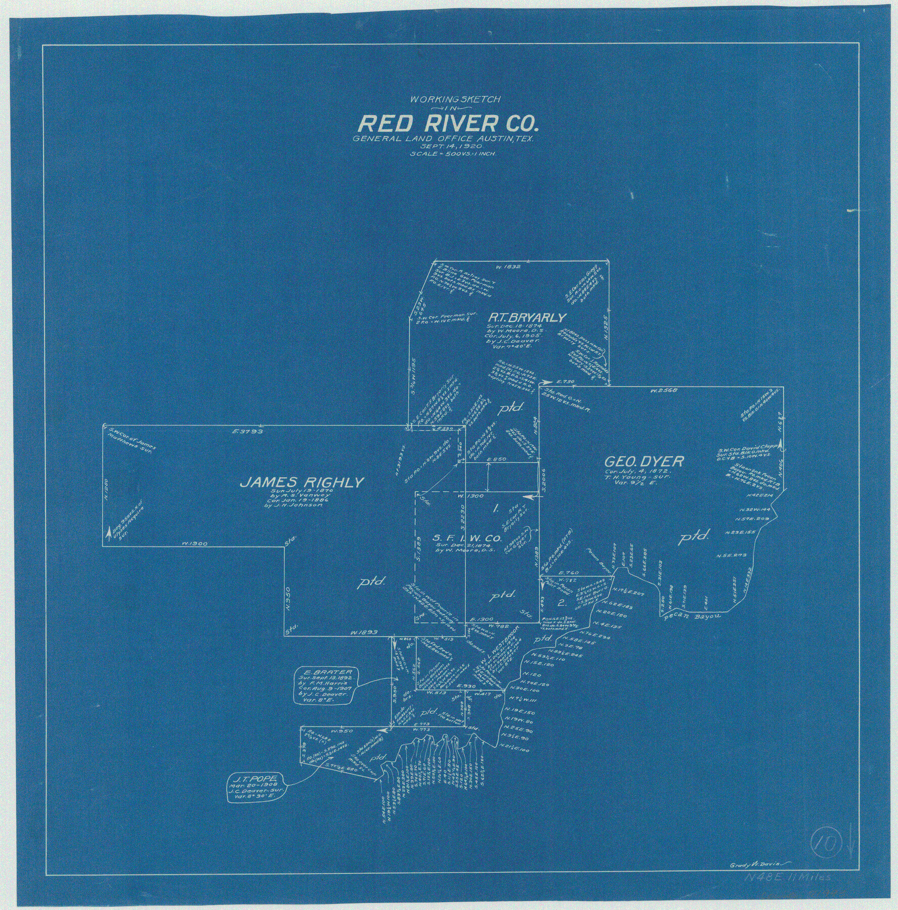
Red River County Working Sketch 10
-
Map/Doc
71993
-
Collection
General Map Collection
-
Object Dates
9/14/1920 (Creation Date)
-
People and Organizations
Grady W. Davis (Draftsman)
-
Counties
Red River
-
Subjects
Surveying Working Sketch
-
Height x Width
19.1 x 18.8 inches
48.5 x 47.8 cm
-
Scale
1" = 500 varas
Part of: General Map Collection
Harris County Boundary File 39

Print $40.00
- Digital $50.00
Harris County Boundary File 39
Size 9.1 x 3.9 inches
Map/Doc 54306
Palo Pinto County Sketch File 3

Print $20.00
- Digital $50.00
Palo Pinto County Sketch File 3
1850
Size 24.6 x 19.3 inches
Map/Doc 12132
Johnson County Working Sketch 4

Print $20.00
- Digital $50.00
Johnson County Working Sketch 4
1948
Size 26.5 x 24.6 inches
Map/Doc 66617
Sutton County Rolled Sketch 70

Print $40.00
- Digital $50.00
Sutton County Rolled Sketch 70
Size 48.7 x 37.0 inches
Map/Doc 9982
Reagan County Working Sketch 21

Print $20.00
- Digital $50.00
Reagan County Working Sketch 21
1955
Size 23.4 x 19.9 inches
Map/Doc 71863
Winkler County Working Sketch 10

Print $40.00
- Digital $50.00
Winkler County Working Sketch 10
1960
Size 30.3 x 61.0 inches
Map/Doc 72604
Matagorda County Boundary File 1a

Print $8.00
- Digital $50.00
Matagorda County Boundary File 1a
Size 14.2 x 8.6 inches
Map/Doc 56889
Travis County Working Sketch 35

Print $20.00
- Digital $50.00
Travis County Working Sketch 35
1966
Size 30.4 x 35.5 inches
Map/Doc 69419
Presidio County Rolled Sketch 131A

Print $20.00
- Digital $50.00
Presidio County Rolled Sketch 131A
1975
Size 30.5 x 24.9 inches
Map/Doc 10706
Flight Mission No. BQR-3K, Frame 155, Brazoria County

Print $20.00
- Digital $50.00
Flight Mission No. BQR-3K, Frame 155, Brazoria County
1952
Size 18.7 x 22.4 inches
Map/Doc 83982
Flight Mission No. DIX-10P, Frame 69, Aransas County

Print $20.00
- Digital $50.00
Flight Mission No. DIX-10P, Frame 69, Aransas County
1956
Size 18.8 x 22.4 inches
Map/Doc 83930
Bexar County Working Sketch 7

Print $20.00
- Digital $50.00
Bexar County Working Sketch 7
1947
Size 21.8 x 37.6 inches
Map/Doc 67323
You may also like
General Highway Map, Garza County, Texas

Print $20.00
General Highway Map, Garza County, Texas
1940
Size 18.1 x 24.6 inches
Map/Doc 79098
El Paso County Rolled Sketch 57B

Print $40.00
- Digital $50.00
El Paso County Rolled Sketch 57B
1984
Size 49.0 x 37.1 inches
Map/Doc 8880
Hopkins County Sketch File 4

Print $47.00
- Digital $50.00
Hopkins County Sketch File 4
Size 21.2 x 18.4 inches
Map/Doc 4565
Flight Mission No. DQN-1K, Frame 157, Calhoun County

Print $20.00
- Digital $50.00
Flight Mission No. DQN-1K, Frame 157, Calhoun County
1953
Size 18.4 x 22.2 inches
Map/Doc 84216
Plat Showing Land Owned by City of Lubbock out of Section 3, Block O

Print $20.00
- Digital $50.00
Plat Showing Land Owned by City of Lubbock out of Section 3, Block O
Size 40.4 x 31.1 inches
Map/Doc 92876
Coryell County Sketch File 17 1/4

Print $4.00
- Digital $50.00
Coryell County Sketch File 17 1/4
Size 8.7 x 14.9 inches
Map/Doc 19377
Udell -V- Hughes Sketch

Print $20.00
- Digital $50.00
Udell -V- Hughes Sketch
Size 41.6 x 26.7 inches
Map/Doc 90894
General Highway Map, San Augustine County, Texas

Print $20.00
General Highway Map, San Augustine County, Texas
1940
Size 24.8 x 18.3 inches
Map/Doc 79235
Map of the Northwest Portion of Hutchinson County Showing the Proposed Resurvey of Block M24

Print $20.00
- Digital $50.00
Map of the Northwest Portion of Hutchinson County Showing the Proposed Resurvey of Block M24
Size 32.4 x 30.1 inches
Map/Doc 91237
Flight Mission No. BQR-3K, Frame 156, Brazoria County

Print $20.00
- Digital $50.00
Flight Mission No. BQR-3K, Frame 156, Brazoria County
1952
Size 18.6 x 22.4 inches
Map/Doc 83983
[Randall County map]
![91752, [Randall County map], Twichell Survey Records](https://historictexasmaps.com/wmedia_w700/maps/91752-1.tif.jpg)
Print $20.00
- Digital $50.00
[Randall County map]
Size 21.3 x 17.0 inches
Map/Doc 91752
Crockett County Working Sketch 97

Print $20.00
- Digital $50.00
Crockett County Working Sketch 97
1979
Size 39.4 x 37.4 inches
Map/Doc 68430