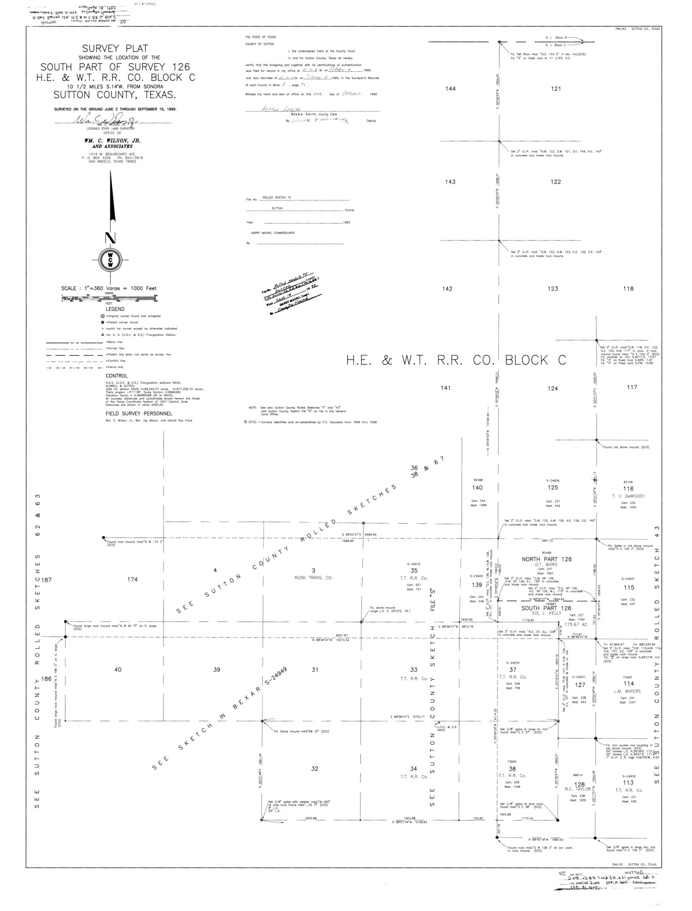
Sutton County Rolled Sketch 70
Survey plat showing the location of the south part of survey 126, H. E. & W. T. R.R. Co. Block C
-
Map/Doc
9982
-
Collection
General Map Collection
-
Object Dates
1995/9/15 (Survey Date)
1995/9/18 (File Date)
-
People and Organizations
Wm. C. Wilson, Jr. (Surveyor/Engineer)
-
Counties
Sutton
-
Subjects
Surveying Rolled Sketch
-
Height x Width
48.7 x 37.0 inches
123.7 x 94.0 cm
-
Medium
mylar, print
-
Scale
1" = 360 varas
Part of: General Map Collection
Montgomery County Rolled Sketch 18

Print $40.00
- Digital $50.00
Montgomery County Rolled Sketch 18
Size 51.4 x 25.3 inches
Map/Doc 9528
Stonewall County Rolled Sketch 24B

Print $40.00
- Digital $50.00
Stonewall County Rolled Sketch 24B
1954
Size 50.1 x 43.1 inches
Map/Doc 9964
Flight Mission No. DQO-2K, Frame 91, Galveston County

Print $20.00
- Digital $50.00
Flight Mission No. DQO-2K, Frame 91, Galveston County
1952
Size 18.8 x 22.5 inches
Map/Doc 85018
Harris County NRC Article 33.136 Sketch 4

Print $22.00
- Digital $50.00
Harris County NRC Article 33.136 Sketch 4
2001
Size 36.1 x 24.3 inches
Map/Doc 61600
S. M. S. Flat Top Ranch

Print $6.00
- Digital $50.00
S. M. S. Flat Top Ranch
1955
Size 23.2 x 32.8 inches
Map/Doc 2102
Ward County Rolled Sketch PMY

Print $40.00
- Digital $50.00
Ward County Rolled Sketch PMY
1935
Size 14.4 x 74.5 inches
Map/Doc 10104
Jackson County Sketch File 22

Print $10.00
- Digital $50.00
Jackson County Sketch File 22
Size 11.2 x 8.7 inches
Map/Doc 27698
Montague County Rolled Sketch 8

Print $20.00
- Digital $50.00
Montague County Rolled Sketch 8
Size 25.4 x 21.8 inches
Map/Doc 6792
Brewster County Sketch File 39

Print $4.00
- Digital $50.00
Brewster County Sketch File 39
Size 12.8 x 8.9 inches
Map/Doc 16300
Dimmit County Sketch File 42

Print $2.00
- Digital $50.00
Dimmit County Sketch File 42
1901
Size 6.2 x 3.9 inches
Map/Doc 21171
Cooke County Working Sketch 31

Print $20.00
- Digital $50.00
Cooke County Working Sketch 31
1980
Size 27.0 x 32.2 inches
Map/Doc 68268
Galveston County Sketch File 18

Print $4.00
- Digital $50.00
Galveston County Sketch File 18
Size 5.5 x 8.0 inches
Map/Doc 23388
You may also like
Reagan County Rolled Sketch 2

Print $40.00
- Digital $50.00
Reagan County Rolled Sketch 2
1903
Size 52.4 x 37.3 inches
Map/Doc 10621
General Highway Map, Johnson County, Texas

Print $20.00
General Highway Map, Johnson County, Texas
1940
Size 18.3 x 24.8 inches
Map/Doc 79149
Kerr County Working Sketch 23

Print $20.00
- Digital $50.00
Kerr County Working Sketch 23
1966
Size 33.4 x 41.0 inches
Map/Doc 70054
Bandera County Boundary File 3

Print $2.00
- Digital $50.00
Bandera County Boundary File 3
Size 4.3 x 8.8 inches
Map/Doc 50266

![88956, Hood Co[unty], Library of Congress](https://historictexasmaps.com/wmedia_w700/maps/88956.tif.jpg)
Coke County Boundary File 2

Print $64.00
- Digital $50.00
Coke County Boundary File 2
Size 49.0 x 9.0 inches
Map/Doc 51580
Ector County Boundary File 3

Print $18.00
- Digital $50.00
Ector County Boundary File 3
Size 9.0 x 4.4 inches
Map/Doc 52836
Fort Bend County Sketch File 4

Print $4.00
- Digital $50.00
Fort Bend County Sketch File 4
1876
Size 10.0 x 8.4 inches
Map/Doc 22885
Kinney County Rolled Sketch 9

Print $20.00
- Digital $50.00
Kinney County Rolled Sketch 9
Size 39.4 x 27.5 inches
Map/Doc 6538
Map of the country upon the Brazos and Big Witchita Rivers

Print $20.00
- Digital $50.00
Map of the country upon the Brazos and Big Witchita Rivers
1854
Size 30.3 x 34.9 inches
Map/Doc 4663
Potter County Rolled Sketch 11

Print $20.00
- Digital $50.00
Potter County Rolled Sketch 11
1986
Size 21.6 x 27.4 inches
Map/Doc 7324