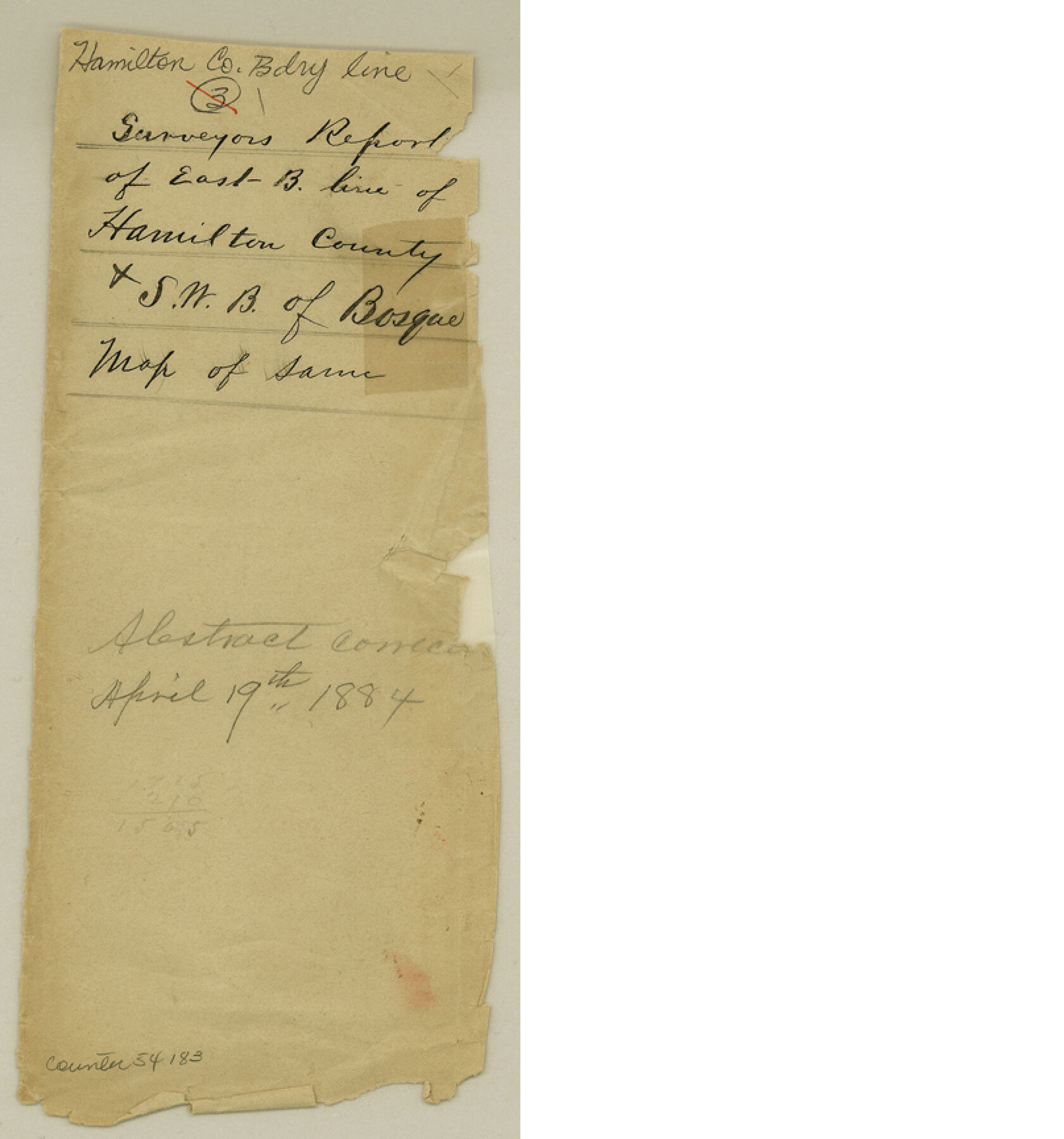
Hamilton County Boundary File 1
Report of East Boundary line Hamilton Co.
-
Map/Doc
54183
-
Collection
General Map Collection
-
Counties
Hamilton
-
Subjects
County Boundaries
-
Height x Width
8.6 x 8.1 inches
21.8 x 20.6 cm
Part of: General Map Collection
Lampasas County

Print $20.00
- Digital $50.00
Lampasas County
1972
Size 35.6 x 44.6 inches
Map/Doc 95565
Kimble County

Print $40.00
- Digital $50.00
Kimble County
1890
Size 38.8 x 58.1 inches
Map/Doc 78414
Flight Mission No. DQN-2K, Frame 121, Calhoun County

Print $20.00
- Digital $50.00
Flight Mission No. DQN-2K, Frame 121, Calhoun County
1953
Size 16.3 x 16.3 inches
Map/Doc 84297
Red River County Sketch File 11

Print $4.00
- Digital $50.00
Red River County Sketch File 11
Size 11.8 x 8.1 inches
Map/Doc 35127
Grayson County Working Sketch 27

Print $20.00
- Digital $50.00
Grayson County Working Sketch 27
1988
Size 29.8 x 35.9 inches
Map/Doc 63266
Southern Pacific R.R. and connections

Print $20.00
- Digital $50.00
Southern Pacific R.R. and connections
1883
Size 27.9 x 32.5 inches
Map/Doc 94270
Culberson County Rolled Sketch 69

Print $20.00
- Digital $50.00
Culberson County Rolled Sketch 69
Size 33.5 x 22.9 inches
Map/Doc 76425
Calhoun County Boundary File 2

Print $50.00
- Digital $50.00
Calhoun County Boundary File 2
Size 9.1 x 7.7 inches
Map/Doc 50968
Jeff Davis County Working Sketch 3

Print $20.00
- Digital $50.00
Jeff Davis County Working Sketch 3
1914
Size 17.8 x 16.9 inches
Map/Doc 66498
Sherman County Sketch File 6

Print $2.00
- Digital $50.00
Sherman County Sketch File 6
1993
Size 14.6 x 9.1 inches
Map/Doc 36724
Isogonic Chart and Meridian Changes, University Land, Hudspeth County, Texas

Print $20.00
- Digital $50.00
Isogonic Chart and Meridian Changes, University Land, Hudspeth County, Texas
Size 28.5 x 34.1 inches
Map/Doc 62953
Briscoe County Working Sketch 3

Print $20.00
- Digital $50.00
Briscoe County Working Sketch 3
1916
Size 28.1 x 22.0 inches
Map/Doc 67806
You may also like
Matagorda County Sketch File 8

Print $4.00
- Digital $50.00
Matagorda County Sketch File 8
1877
Size 12.9 x 8.0 inches
Map/Doc 30750
Dawson County

Print $20.00
- Digital $50.00
Dawson County
1959
Size 42.4 x 34.8 inches
Map/Doc 73127
Presidio County Sketch File 3

Print $6.00
- Digital $50.00
Presidio County Sketch File 3
1941
Size 8.5 x 7.7 inches
Map/Doc 34423
Leon County Working Sketch 58

Print $20.00
- Digital $50.00
Leon County Working Sketch 58
1986
Size 27.7 x 43.3 inches
Map/Doc 70458
Hidalgo County Working Sketch 6

Print $20.00
- Digital $50.00
Hidalgo County Working Sketch 6
1960
Size 21.4 x 20.4 inches
Map/Doc 66183
[Map of Nueces Bay Showing Old Leases]
![2924, [Map of Nueces Bay Showing Old Leases], General Map Collection](https://historictexasmaps.com/wmedia_w700/maps/2924-1.tif.jpg)
Print $20.00
- Digital $50.00
[Map of Nueces Bay Showing Old Leases]
1936
Size 18.0 x 22.9 inches
Map/Doc 2924
Fort Worth, Tex. "The Queen of the Prairies," County Seat of Tarrant County

Print $20.00
Fort Worth, Tex. "The Queen of the Prairies," County Seat of Tarrant County
1886
Size 26.0 x 33.3 inches
Map/Doc 89082
Stanton Acres, a Subdivision of Tracts 2 and 3, Block 1; and Tract 1, Block 2]
![91336, Stanton Acres, a Subdivision of Tracts 2 and 3, Block 1; and Tract 1, Block 2], Twichell Survey Records](https://historictexasmaps.com/wmedia_w700/maps/91336-1.tif.jpg)
Print $3.00
- Digital $50.00
Stanton Acres, a Subdivision of Tracts 2 and 3, Block 1; and Tract 1, Block 2]
Size 9.4 x 11.8 inches
Map/Doc 91336
Map of the City of Aransas Pass

Print $20.00
- Digital $50.00
Map of the City of Aransas Pass
1905
Size 28.3 x 21.4 inches
Map/Doc 97266
Hunt County Sketch File 21

Print $4.00
- Digital $50.00
Hunt County Sketch File 21
Size 8.1 x 5.8 inches
Map/Doc 27122
Flight Mission No. BQY-4M, Frame 43, Harris County

Print $20.00
- Digital $50.00
Flight Mission No. BQY-4M, Frame 43, Harris County
1953
Size 18.6 x 22.3 inches
Map/Doc 85258
