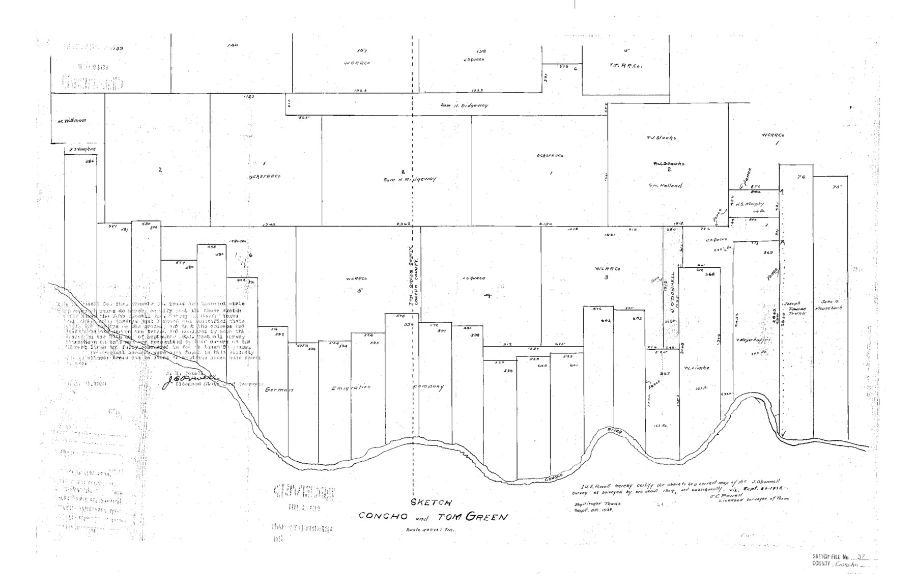
Concho County Sketch File 37
Sketch Concho and Tom Green
-
Map/Doc
11162
-
Collection
General Map Collection
-
Object Dates
1938/9/20 (Creation Date)
1938/9/28 (File Date)
-
People and Organizations
J.E. Powell (Surveyor/Engineer)
-
Counties
Concho Tom Green
-
Subjects
Surveying Sketch File
-
Height x Width
18.7 x 29.1 inches
47.5 x 73.9 cm
-
Medium
paper, photocopy
-
Scale
1:500
-
Features
Concho River
Part of: General Map Collection
Yoakum County Sketch File 3

Print $54.00
- Digital $50.00
Yoakum County Sketch File 3
1892
Size 14.2 x 8.8 inches
Map/Doc 40705
Houston County Sketch File 24

Print $4.00
- Digital $50.00
Houston County Sketch File 24
1867
Size 14.2 x 8.2 inches
Map/Doc 26796
Waller County Sketch File 1

Print $14.00
- Digital $50.00
Waller County Sketch File 1
Size 8.1 x 6.9 inches
Map/Doc 39563
Intracoastal Waterway - Port Arthur to Galveston Bay

Print $20.00
- Digital $50.00
Intracoastal Waterway - Port Arthur to Galveston Bay
1957
Size 27.0 x 38.6 inches
Map/Doc 69830
Dallas County Working Sketch 4

Print $20.00
- Digital $50.00
Dallas County Working Sketch 4
1935
Size 24.1 x 30.4 inches
Map/Doc 68570
Webb County Sketch File 2 and 2A

Print $20.00
- Digital $50.00
Webb County Sketch File 2 and 2A
Size 39.8 x 29.6 inches
Map/Doc 10428
Garza County Rolled Sketch 12

Print $20.00
- Digital $50.00
Garza County Rolled Sketch 12
1916
Size 31.5 x 26.0 inches
Map/Doc 6069
Jeff Davis County Working Sketch 46

Print $20.00
- Digital $50.00
Jeff Davis County Working Sketch 46
1991
Size 38.8 x 36.7 inches
Map/Doc 66541
Waller County

Print $20.00
- Digital $50.00
Waller County
1945
Size 46.4 x 27.1 inches
Map/Doc 77449
Throckmorton County Sketch File 7b

Print $4.00
- Digital $50.00
Throckmorton County Sketch File 7b
Size 13.0 x 6.5 inches
Map/Doc 38097
Cherokee County Rolled Sketch 3

Print $40.00
- Digital $50.00
Cherokee County Rolled Sketch 3
1955
Size 55.5 x 35.2 inches
Map/Doc 8597
Map of Zavalla County

Print $20.00
- Digital $50.00
Map of Zavalla County
1876
Size 22.5 x 33.2 inches
Map/Doc 4181
You may also like
[Surveys in the Bexar District along the Balcones, Cibolo and Leon Creeks]
![63, [Surveys in the Bexar District along the Balcones, Cibolo and Leon Creeks], General Map Collection](https://historictexasmaps.com/wmedia_w700/maps/63.tif.jpg)
Print $3.00
- Digital $50.00
[Surveys in the Bexar District along the Balcones, Cibolo and Leon Creeks]
1842
Size 10.6 x 12.4 inches
Map/Doc 63
Duval County Rolled Sketch 46

Print $20.00
- Digital $50.00
Duval County Rolled Sketch 46
1985
Size 24.9 x 36.1 inches
Map/Doc 5761
Brown County Rolled Sketch 2A

Print $20.00
- Digital $50.00
Brown County Rolled Sketch 2A
1984
Size 25.6 x 37.4 inches
Map/Doc 5350
The Republic County of Montgomery. February 2, 1842

Print $20.00
The Republic County of Montgomery. February 2, 1842
2020
Size 19.9 x 21.7 inches
Map/Doc 96239
Harris County Rolled Sketch 42

Print $20.00
- Digital $50.00
Harris County Rolled Sketch 42
1919
Size 15.7 x 19.5 inches
Map/Doc 6100
Palo Pinto County Working Sketch 2

Print $20.00
- Digital $50.00
Palo Pinto County Working Sketch 2
1906
Size 15.2 x 46.2 inches
Map/Doc 71385
Reeves County Rolled Sketch 10A

Print $20.00
- Digital $50.00
Reeves County Rolled Sketch 10A
Size 22.7 x 42.0 inches
Map/Doc 7481
The Republic County of Brazoria. January 1, 1838

Print $20.00
The Republic County of Brazoria. January 1, 1838
2020
Size 14.7 x 21.8 inches
Map/Doc 96111
Flight Mission No. CLL-1N, Frame 103, Willacy County

Print $20.00
- Digital $50.00
Flight Mission No. CLL-1N, Frame 103, Willacy County
1954
Size 18.4 x 22.1 inches
Map/Doc 87037
Ochiltree County

Print $20.00
- Digital $50.00
Ochiltree County
1958
Size 43.4 x 34.4 inches
Map/Doc 73253
Uvalde County Working Sketch 62

Print $20.00
- Digital $50.00
Uvalde County Working Sketch 62
1993
Size 22.5 x 31.4 inches
Map/Doc 72132
Cherokee County

Print $40.00
- Digital $50.00
Cherokee County
1933
Size 54.7 x 38.7 inches
Map/Doc 73104