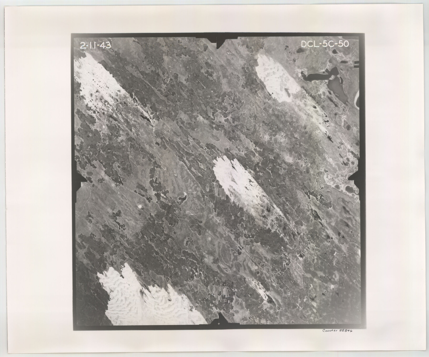
Flight Mission No. DCL-5C, Frame 50, Kenedy County
DCL-5C-50
-
Map/Doc
85846
-
Collection
General Map Collection
-
Object Dates
1943/2/11 (Creation Date)
-
People and Organizations
U. S. Department of Agriculture (Publisher)
-
Counties
Kenedy
-
Subjects
Aerial Photograph
-
Height x Width
18.6 x 22.4 inches
47.2 x 56.9 cm
-
Comments
Flown by Aerial Surveys of Pittsburgh, Inc. of Pittsburgh, Pennsylvania.
Part of: General Map Collection

Presidio County Rolled Sketch 61

Print $20.00
- Digital $50.00
Presidio County Rolled Sketch 61
1914
Size 16.0 x 19.7 inches
Map/Doc 7353
Bell County Working Sketch 12

Print $20.00
- Digital $50.00
Bell County Working Sketch 12
1956
Size 17.2 x 22.0 inches
Map/Doc 67352
Harris County Rolled Sketch 45

Print $20.00
- Digital $50.00
Harris County Rolled Sketch 45
Size 20.2 x 21.0 inches
Map/Doc 6103
Territory served by the Galveston Bay Ports, Tex.

Print $20.00
- Digital $50.00
Territory served by the Galveston Bay Ports, Tex.
Size 17.1 x 16.0 inches
Map/Doc 97165
Surveys in Reeves and Culberson Counties, Texas and Pacific Railroad Company, Blocks 58, 59, 60, and 61

Print $20.00
- Digital $50.00
Surveys in Reeves and Culberson Counties, Texas and Pacific Railroad Company, Blocks 58, 59, 60, and 61
1937
Size 30.7 x 25.3 inches
Map/Doc 2250
Outer Continental Shelf Leasing Maps (Texas Offshore Operations)

Print $20.00
- Digital $50.00
Outer Continental Shelf Leasing Maps (Texas Offshore Operations)
Size 23.4 x 13.0 inches
Map/Doc 75854
Flight Mission No. DAG-17K, Frame 65, Matagorda County

Print $20.00
- Digital $50.00
Flight Mission No. DAG-17K, Frame 65, Matagorda County
1952
Size 17.5 x 16.1 inches
Map/Doc 86327
Kendall County Boundary File 1

Print $6.00
- Digital $50.00
Kendall County Boundary File 1
Size 14.2 x 8.7 inches
Map/Doc 55743
Brewster County Working Sketch 2

Print $20.00
- Digital $50.00
Brewster County Working Sketch 2
1907
Size 29.0 x 26.4 inches
Map/Doc 67535
Edwards County Sketch File 23

Print $8.00
- Digital $50.00
Edwards County Sketch File 23
1881
Size 14.4 x 9.0 inches
Map/Doc 21747
Nueces County NRC Article 33.136 Location Key Sheet

Print $20.00
- Digital $50.00
Nueces County NRC Article 33.136 Location Key Sheet
1975
Size 27.0 x 23.0 inches
Map/Doc 88588
You may also like
Flight Mission No. DCL-7C, Frame 24, Kenedy County

Print $20.00
- Digital $50.00
Flight Mission No. DCL-7C, Frame 24, Kenedy County
1943
Size 15.5 x 15.4 inches
Map/Doc 86016
Nueces County Rolled Sketch 129 A-C

Print $6.00
- Digital $50.00
Nueces County Rolled Sketch 129 A-C
1998
Size 11.2 x 8.8 inches
Map/Doc 41616
Uvalde County Working Sketch 23

Print $20.00
- Digital $50.00
Uvalde County Working Sketch 23
1952
Size 32.0 x 26.6 inches
Map/Doc 72093
Marion County Working Sketch 28

Print $20.00
- Digital $50.00
Marion County Working Sketch 28
1975
Size 24.0 x 33.5 inches
Map/Doc 70804
[Tom Green County]
![16901, [Tom Green County], General Map Collection](https://historictexasmaps.com/wmedia_w700/maps/16901.tif.jpg)
Print $20.00
- Digital $50.00
[Tom Green County]
1888
Size 33.2 x 34.4 inches
Map/Doc 16901
Rusk County Sketch File 37

Print $20.00
Rusk County Sketch File 37
1951
Size 23.3 x 26.2 inches
Map/Doc 12275
Arroyo Colorado, Rio Hondo Sheet

Print $40.00
- Digital $50.00
Arroyo Colorado, Rio Hondo Sheet
1929
Size 35.0 x 52.6 inches
Map/Doc 65129
Map of Atascosa County, Texas

Print $20.00
- Digital $50.00
Map of Atascosa County, Texas
1879
Size 23.7 x 29.0 inches
Map/Doc 688
Ochiltree County Sketch File 8

Print $16.00
- Digital $50.00
Ochiltree County Sketch File 8
1933
Size 11.2 x 8.7 inches
Map/Doc 33186
Crockett County Sketch File 13

Print $22.00
- Digital $50.00
Crockett County Sketch File 13
Size 8.9 x 3.6 inches
Map/Doc 19665
McCulloch County Sketch File 2

Print $4.00
- Digital $50.00
McCulloch County Sketch File 2
1872
Size 12.8 x 8.1 inches
Map/Doc 31167
College Heights a Subdivision of Outlots 8-9 and 62, Division B, Austin, Texas

Print $20.00
- Digital $50.00
College Heights a Subdivision of Outlots 8-9 and 62, Division B, Austin, Texas
Size 18.5 x 14.9 inches
Map/Doc 83429