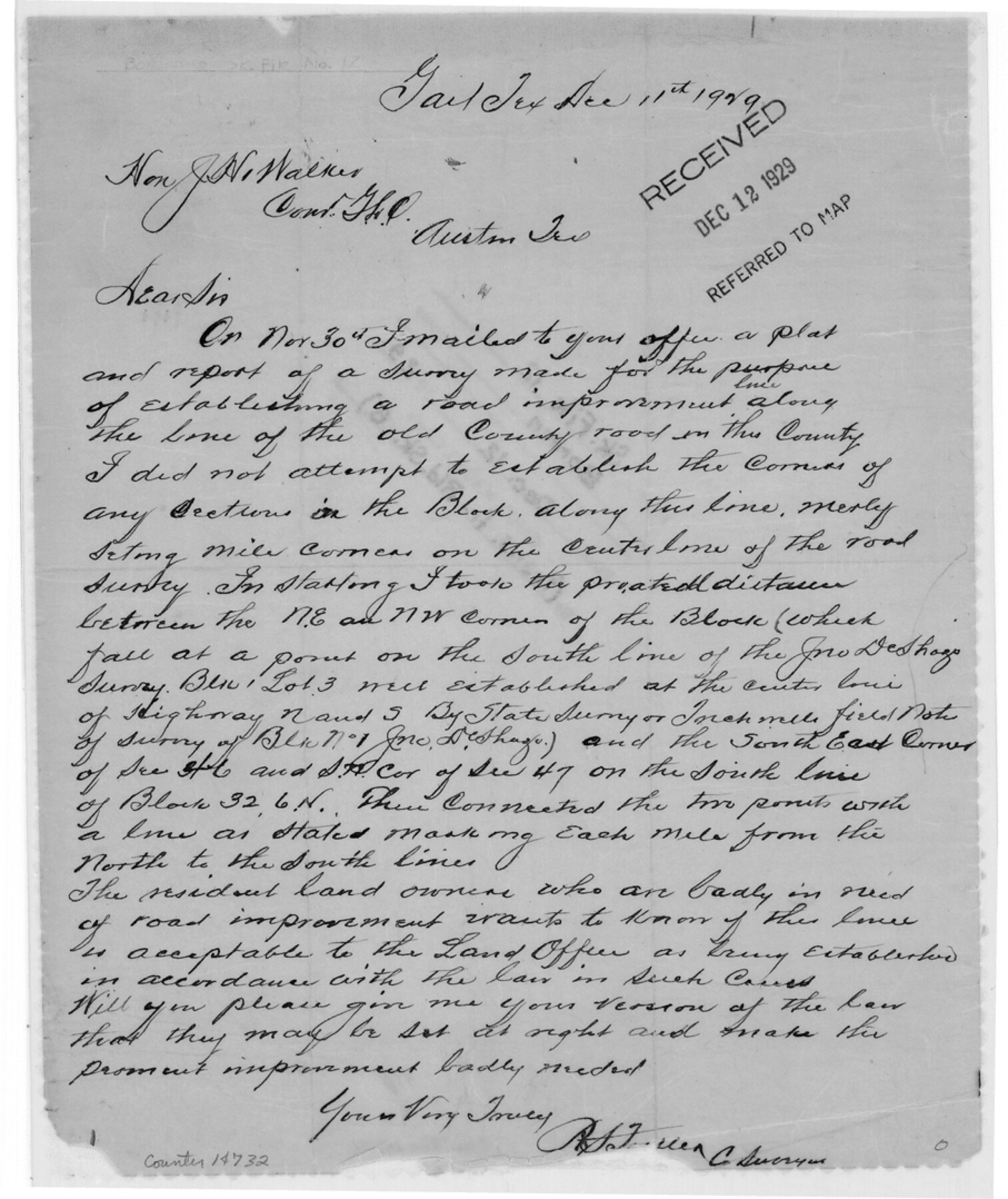
Borden County Sketch File 12
[Copy of report and petition for survey of Block 32, Township 6 North, T. & P. R.R. Co.]
-
Map/Doc
14732
-
Collection
General Map Collection
-
Object Dates
1929/12/11 (Correspondence Date)
1929/12/12 (File Date)
1929/11/29 (Correspondence Date)
-
People and Organizations
R.S. Fuller (Surveyor/Engineer)
-
Counties
Borden
-
Subjects
Surveying Sketch File
-
Height x Width
10.8 x 9.1 inches
27.4 x 23.1 cm
-
Medium
multi-page, multi-format
-
Comments
See Borden County Rolled Sketch 6 (5156) for sketch.
-
Features
Muchuka Peak
Related maps
Borden County Rolled Sketch 6

Print $20.00
- Digital $50.00
Borden County Rolled Sketch 6
Size 24.6 x 18.6 inches
Map/Doc 5156
Part of: General Map Collection
Edwards County Working Sketch 15

Print $20.00
- Digital $50.00
Edwards County Working Sketch 15
1927
Size 30.0 x 28.4 inches
Map/Doc 68891
Sterling County

Print $20.00
- Digital $50.00
Sterling County
1971
Size 42.8 x 31.1 inches
Map/Doc 77427
Tyler County Sketch File 7

Print $4.00
- Digital $50.00
Tyler County Sketch File 7
1874
Size 13.4 x 7.7 inches
Map/Doc 38637
Hall County Rolled Sketch D

Print $20.00
- Digital $50.00
Hall County Rolled Sketch D
Size 20.0 x 26.4 inches
Map/Doc 6054
Flight Mission No. DAG-17K, Frame 135, Matagorda County

Print $20.00
- Digital $50.00
Flight Mission No. DAG-17K, Frame 135, Matagorda County
1952
Size 17.4 x 16.1 inches
Map/Doc 86352
[FT. W. & R. G. Ry. Right of Way Map, Winchell to Brady, McCulloch County, Texas]
![61414, [FT. W. & R. G. Ry. Right of Way Map, Winchell to Brady, McCulloch County, Texas], General Map Collection](https://historictexasmaps.com/wmedia_w700/maps/61414.tif.jpg)
Print $40.00
- Digital $50.00
[FT. W. & R. G. Ry. Right of Way Map, Winchell to Brady, McCulloch County, Texas]
1918
Size 38.2 x 122.0 inches
Map/Doc 61414
Wilbarger County Sketch File 20

Print $4.00
- Digital $50.00
Wilbarger County Sketch File 20
1885
Size 12.7 x 8.2 inches
Map/Doc 40217
Nueces River, Clarkwood Sheet

Print $6.00
- Digital $50.00
Nueces River, Clarkwood Sheet
1942
Size 26.9 x 36.5 inches
Map/Doc 65099
Amistad International Reservoir on Rio Grande 74a

Print $20.00
- Digital $50.00
Amistad International Reservoir on Rio Grande 74a
1949
Size 28.6 x 40.0 inches
Map/Doc 75502
Flight Mission No. DAG-24K, Frame 40, Matagorda County

Print $20.00
- Digital $50.00
Flight Mission No. DAG-24K, Frame 40, Matagorda County
1953
Size 18.5 x 22.3 inches
Map/Doc 86527
Harris County Sketch File 73

Print $6.00
- Digital $50.00
Harris County Sketch File 73
1942
Size 11.3 x 8.9 inches
Map/Doc 25539
Lampasas County Sketch File 15

Print $20.00
- Digital $50.00
Lampasas County Sketch File 15
1888
Size 24.5 x 27.1 inches
Map/Doc 11975
You may also like
Purnell and Lovell Empresario Colony. October 22, 1825

Print $20.00
Purnell and Lovell Empresario Colony. October 22, 1825
2020
Size 18.1 x 21.6 inches
Map/Doc 96005
Anderson County Working Sketch 7

Print $20.00
- Digital $50.00
Anderson County Working Sketch 7
1920
Size 27.3 x 30.2 inches
Map/Doc 67006
Marion County Rolled Sketch F

Print $40.00
- Digital $50.00
Marion County Rolled Sketch F
1937
Size 43.5 x 67.1 inches
Map/Doc 9487
Lavaca County Working Sketch 26

Print $20.00
- Digital $50.00
Lavaca County Working Sketch 26
1986
Size 25.0 x 28.1 inches
Map/Doc 70379
El Paso County Rolled Sketch 58

Print $20.00
- Digital $50.00
El Paso County Rolled Sketch 58
1987
Size 18.6 x 24.6 inches
Map/Doc 5851
Carte de la côte de la Louisiane depuis la Baye St. Joseph, jusqu'à celle de St. Bernard où tous les ports et bons mouillages sont marquez par des ancres; avec la quantité de piés d'eau que l'on y trouve.

Print $20.00
Carte de la côte de la Louisiane depuis la Baye St. Joseph, jusqu'à celle de St. Bernard où tous les ports et bons mouillages sont marquez par des ancres; avec la quantité de piés d'eau que l'on y trouve.
1732
Size 11.4 x 32.7 inches
Map/Doc 93607

Travis County Rolled Sketch 28

Print $20.00
- Digital $50.00
Travis County Rolled Sketch 28
1941
Size 22.7 x 27.0 inches
Map/Doc 8030
San Jacinto County Working Sketch 38

Print $40.00
- Digital $50.00
San Jacinto County Working Sketch 38
1966
Size 41.5 x 55.9 inches
Map/Doc 63751
Live Oak County Sketch File 30

Print $6.00
- Digital $50.00
Live Oak County Sketch File 30
1925
Size 14.1 x 8.8 inches
Map/Doc 30322
Armstrong County Rolled Sketch ACP

Print $20.00
- Digital $50.00
Armstrong County Rolled Sketch ACP
1900
Size 33.0 x 35.3 inches
Map/Doc 8425
Map of Lampasas County, Texas

Print $20.00
- Digital $50.00
Map of Lampasas County, Texas
1879
Size 23.4 x 28.4 inches
Map/Doc 560