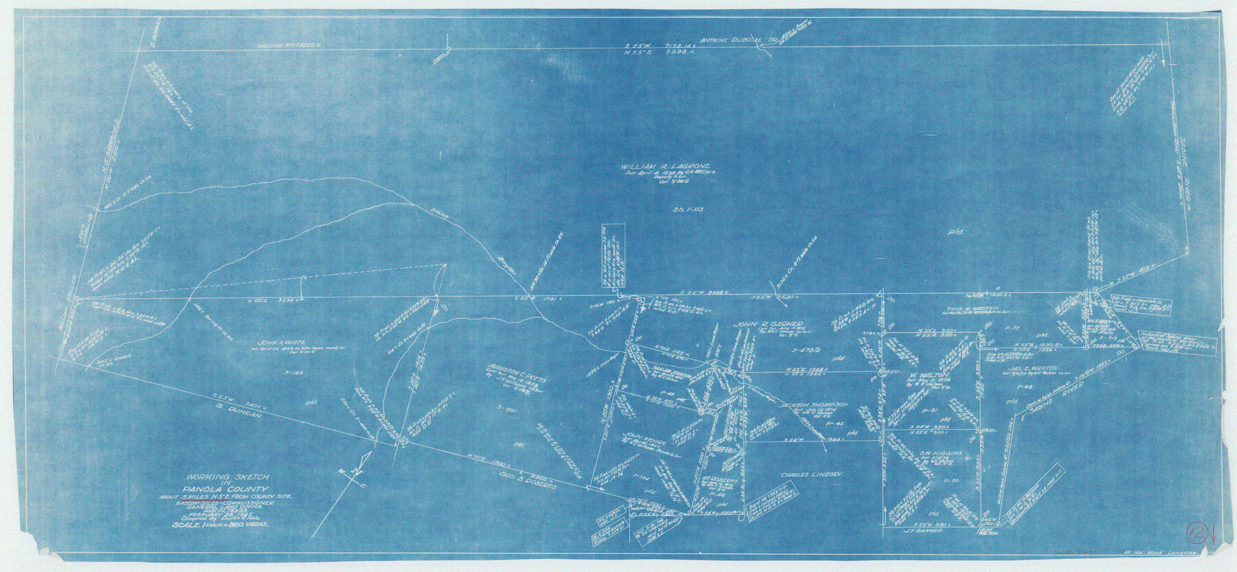
Panola County Working Sketch 12
-
Map/Doc
71421
-
Collection
General Map Collection
-
Object Dates
2/28/1945 (Creation Date)
-
People and Organizations
Curtis R. Hale (Compiler)
-
Counties
Panola
-
Subjects
Surveying Working Sketch
-
Scale
1" = 300 varas
Part of: General Map Collection
[Surveys along Neils and Turkey Creeks]
![69761, [Surveys along Neils and Turkey Creeks], General Map Collection](https://historictexasmaps.com/wmedia_w700/maps/69761.tif.jpg)
Print $2.00
- Digital $50.00
[Surveys along Neils and Turkey Creeks]
1846
Size 10.8 x 7.9 inches
Map/Doc 69761
Liberty County

Print $20.00
- Digital $50.00
Liberty County
1862
Size 24.3 x 24.8 inches
Map/Doc 3815
Fort Bend County Sketch File 24

Print $20.00
- Digital $50.00
Fort Bend County Sketch File 24
1890
Size 23.5 x 32.4 inches
Map/Doc 11509
Flight Mission No. DQO-8K, Frame 142, Galveston County

Print $20.00
- Digital $50.00
Flight Mission No. DQO-8K, Frame 142, Galveston County
1952
Size 18.6 x 22.3 inches
Map/Doc 85204
Harris County Working Sketch 49

Print $20.00
- Digital $50.00
Harris County Working Sketch 49
1944
Size 28.7 x 33.9 inches
Map/Doc 65941
Howard County Sketch File 2a

Print $20.00
- Digital $50.00
Howard County Sketch File 2a
1909
Size 32.8 x 25.6 inches
Map/Doc 11792
Brooks County Working Sketch 6

Print $20.00
- Digital $50.00
Brooks County Working Sketch 6
1917
Size 28.6 x 15.7 inches
Map/Doc 67790
Hudspeth County Working Sketch 62

Print $20.00
- Digital $50.00
Hudspeth County Working Sketch 62
1993
Size 23.9 x 32.4 inches
Map/Doc 66347
Caldwell County

Print $20.00
- Digital $50.00
Caldwell County
1935
Size 36.1 x 40.3 inches
Map/Doc 77227
Flight Mission No. DCL-6C, Frame 21, Kenedy County

Print $20.00
- Digital $50.00
Flight Mission No. DCL-6C, Frame 21, Kenedy County
1943
Size 18.7 x 22.5 inches
Map/Doc 85878
Harris County Working Sketch 66

Print $40.00
- Digital $50.00
Harris County Working Sketch 66
1955
Size 33.7 x 49.7 inches
Map/Doc 65958
Childress County Sketch File 16

Print $8.00
- Digital $50.00
Childress County Sketch File 16
1888
Size 13.9 x 8.5 inches
Map/Doc 18282
You may also like
[Sketch of expeditions, trails in Jones, Taylor, Shackelford, Callahan, Buchanan/Stephens and Eastland Counties]
![65405, [Sketch of expeditions, trails in Jones, Taylor, Shackelford, Callahan, Buchanan/Stephens and Eastland Counties], General Map Collection](https://historictexasmaps.com/wmedia_w700/maps/65405.tif.jpg)
Print $4.00
- Digital $50.00
[Sketch of expeditions, trails in Jones, Taylor, Shackelford, Callahan, Buchanan/Stephens and Eastland Counties]
1873
Size 10.8 x 18.3 inches
Map/Doc 65405
Harris County NRC Article 33.136 Sketch 4

Print $22.00
- Digital $50.00
Harris County NRC Article 33.136 Sketch 4
2001
Size 36.1 x 24.3 inches
Map/Doc 61600
Dickens County Sketch File 32

Print $20.00
- Digital $50.00
Dickens County Sketch File 32
Size 32.8 x 30.6 inches
Map/Doc 11328
Palo Pinto County Working Sketch 22

Print $20.00
- Digital $50.00
Palo Pinto County Working Sketch 22
1985
Map/Doc 71405
Hunt County Working Sketch 11

Print $20.00
- Digital $50.00
Hunt County Working Sketch 11
2002
Size 32.1 x 29.6 inches
Map/Doc 66358
Flight Mission No. CRC-2R, Frame 58, Chambers County

Print $20.00
- Digital $50.00
Flight Mission No. CRC-2R, Frame 58, Chambers County
1956
Size 18.8 x 22.6 inches
Map/Doc 84729
[Block N and part of Block B]
![90363, [Block N and part of Block B], Twichell Survey Records](https://historictexasmaps.com/wmedia_w700/maps/90363-1.tif.jpg)
Print $3.00
- Digital $50.00
[Block N and part of Block B]
Size 9.6 x 12.8 inches
Map/Doc 90363
Harris County Sketch File 81

Print $20.00
- Digital $50.00
Harris County Sketch File 81
Size 25.5 x 16.5 inches
Map/Doc 11669
Jefferson County Working Sketch 12

Print $20.00
- Digital $50.00
Jefferson County Working Sketch 12
1947
Size 29.9 x 39.4 inches
Map/Doc 66555
Duval County Sketch File 26

Print $4.00
- Digital $50.00
Duval County Sketch File 26
1882
Size 13.0 x 9.0 inches
Map/Doc 21332
Hunt County Sketch File 4a

Print $4.00
- Digital $50.00
Hunt County Sketch File 4a
1859
Size 12.6 x 8.2 inches
Map/Doc 27089
Presidio County Rolled Sketch S

Print $20.00
- Digital $50.00
Presidio County Rolled Sketch S
1915
Size 15.6 x 15.4 inches
Map/Doc 7413