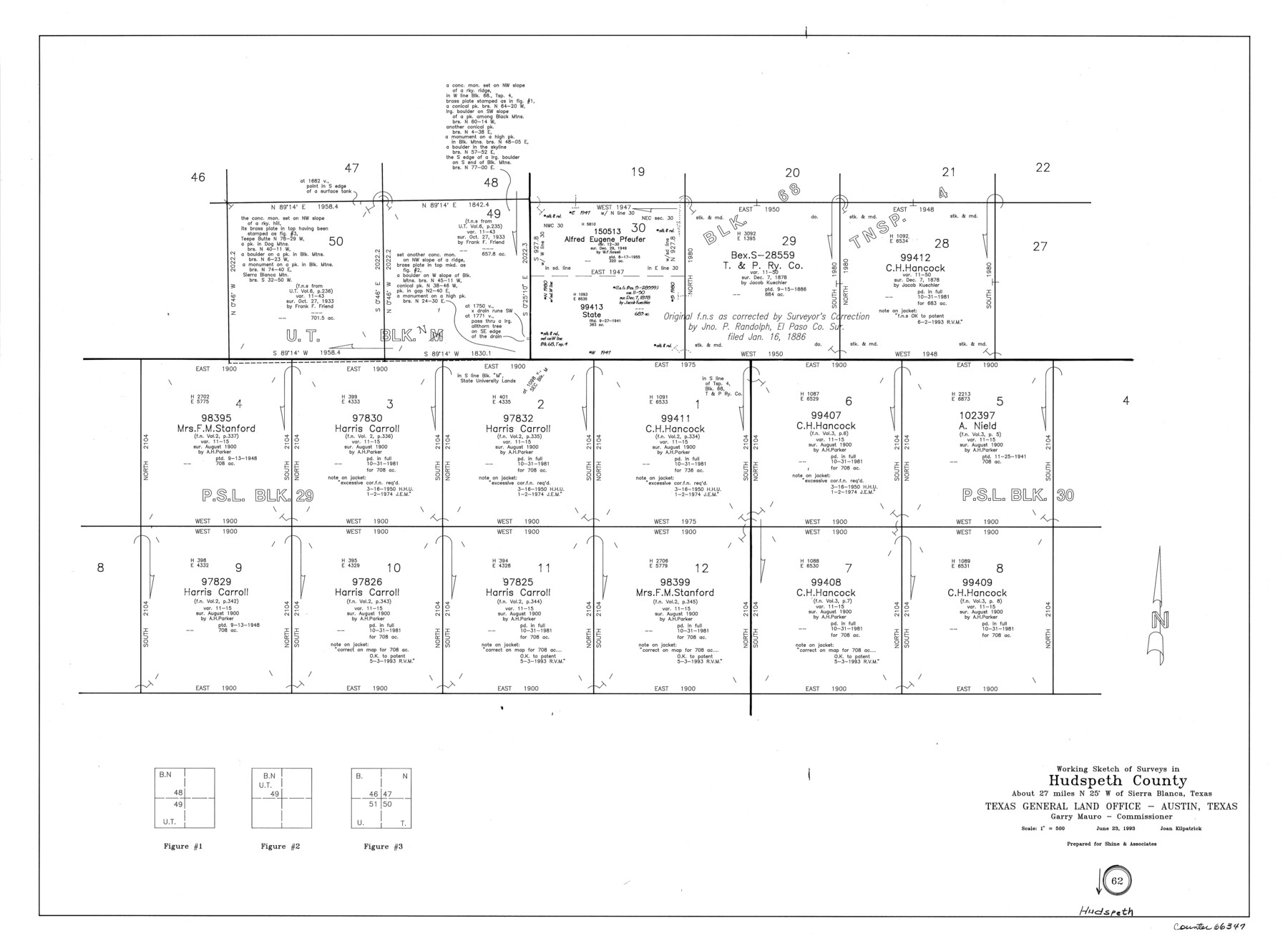
Hudspeth County Working Sketch 62
-
Map/Doc
66347
-
Collection
General Map Collection
-
Object Dates
6/23/1993 (Creation Date)
-
People and Organizations
Joan Kilpatrick (Draftsman)
-
Counties
Hudspeth
-
Subjects
Surveying Working Sketch
-
Height x Width
23.9 x 32.4 inches
60.7 x 82.3 cm
-
Scale
1" = 500 varas
Part of: General Map Collection
Lubbock County Sketch File 14

Print $4.00
- Digital $50.00
Lubbock County Sketch File 14
1892
Size 11.2 x 8.9 inches
Map/Doc 30438
Jasper County Rolled Sketch 5

Print $20.00
- Digital $50.00
Jasper County Rolled Sketch 5
1948
Size 29.0 x 24.4 inches
Map/Doc 6352
Map of Concho County

Print $20.00
- Digital $50.00
Map of Concho County
1879
Size 23.4 x 18.3 inches
Map/Doc 4523
El Paso County Working Sketch 50

Print $20.00
- Digital $50.00
El Paso County Working Sketch 50
1991
Size 25.9 x 27.7 inches
Map/Doc 69072
Jefferson County Rolled Sketch 61A

Print $20.00
- Digital $50.00
Jefferson County Rolled Sketch 61A
1928
Size 27.2 x 40.4 inches
Map/Doc 6410
[Aransas National Wildlife Refuge]
![3119, [Aransas National Wildlife Refuge], General Map Collection](https://historictexasmaps.com/wmedia_w700/maps/3119-1.tif.jpg)
Print $40.00
- Digital $50.00
[Aransas National Wildlife Refuge]
1952
Size 55.9 x 43.4 inches
Map/Doc 3119
Tom Green County Rolled Sketch 22

Print $20.00
- Digital $50.00
Tom Green County Rolled Sketch 22
1966
Size 38.0 x 43.6 inches
Map/Doc 10006
Duval County Sketch File 47

Print $6.00
- Digital $50.00
Duval County Sketch File 47
Size 11.5 x 8.8 inches
Map/Doc 21402
Atascosa County Working Sketch 26

Print $20.00
- Digital $50.00
Atascosa County Working Sketch 26
1960
Size 46.9 x 43.7 inches
Map/Doc 67222
Kinney County Working Sketch 18

Print $40.00
- Digital $50.00
Kinney County Working Sketch 18
1948
Size 56.7 x 40.5 inches
Map/Doc 70200
Llano County Sketch File 2

Print $6.00
- Digital $50.00
Llano County Sketch File 2
Size 9.6 x 8.6 inches
Map/Doc 30347
Smith County Rolled Sketch 6C

Print $20.00
- Digital $50.00
Smith County Rolled Sketch 6C
1943
Size 25.7 x 34.4 inches
Map/Doc 10701
You may also like
Flight Mission No. DQO-1K, Frame 41, Galveston County

Print $20.00
- Digital $50.00
Flight Mission No. DQO-1K, Frame 41, Galveston County
1952
Size 18.8 x 22.5 inches
Map/Doc 84984
Map of section no. 10 of a survey of Padre Island made for the Office of the Attorney General of the State of Texas

Print $40.00
- Digital $50.00
Map of section no. 10 of a survey of Padre Island made for the Office of the Attorney General of the State of Texas
1941
Size 57.2 x 40.6 inches
Map/Doc 2266

Nacogdoches County

Print $20.00
- Digital $50.00
Nacogdoches County
1950
Size 47.0 x 43.1 inches
Map/Doc 73248
Roberts County Boundary File 2c

Print $28.00
- Digital $50.00
Roberts County Boundary File 2c
Size 9.5 x 28.3 inches
Map/Doc 58363

Desdemona Oil Pool

Print $20.00
- Digital $50.00
Desdemona Oil Pool
Size 38.7 x 43.1 inches
Map/Doc 89773
Lubbock County Sketch File 14
Print $4.00
- Digital $50.00
Lubbock County Sketch File 14
1892
Size 11.2 x 8.9 inches
Map/Doc 30438
Bailey County

Print $20.00
- Digital $50.00
Bailey County
1913
Size 29.0 x 22.5 inches
Map/Doc 66708
Brewster County Sketch File FN-30

Print $4.00
- Digital $50.00
Brewster County Sketch File FN-30
1975
Size 12.0 x 8.7 inches
Map/Doc 15850
2008 Official Travel Map, Texas

2008 Official Travel Map, Texas
Size 33.4 x 36.5 inches
Map/Doc 94343
Pecos County Sketch File 62

Print $40.00
- Digital $50.00
Pecos County Sketch File 62
1919
Size 10.5 x 24.6 inches
Map/Doc 33790