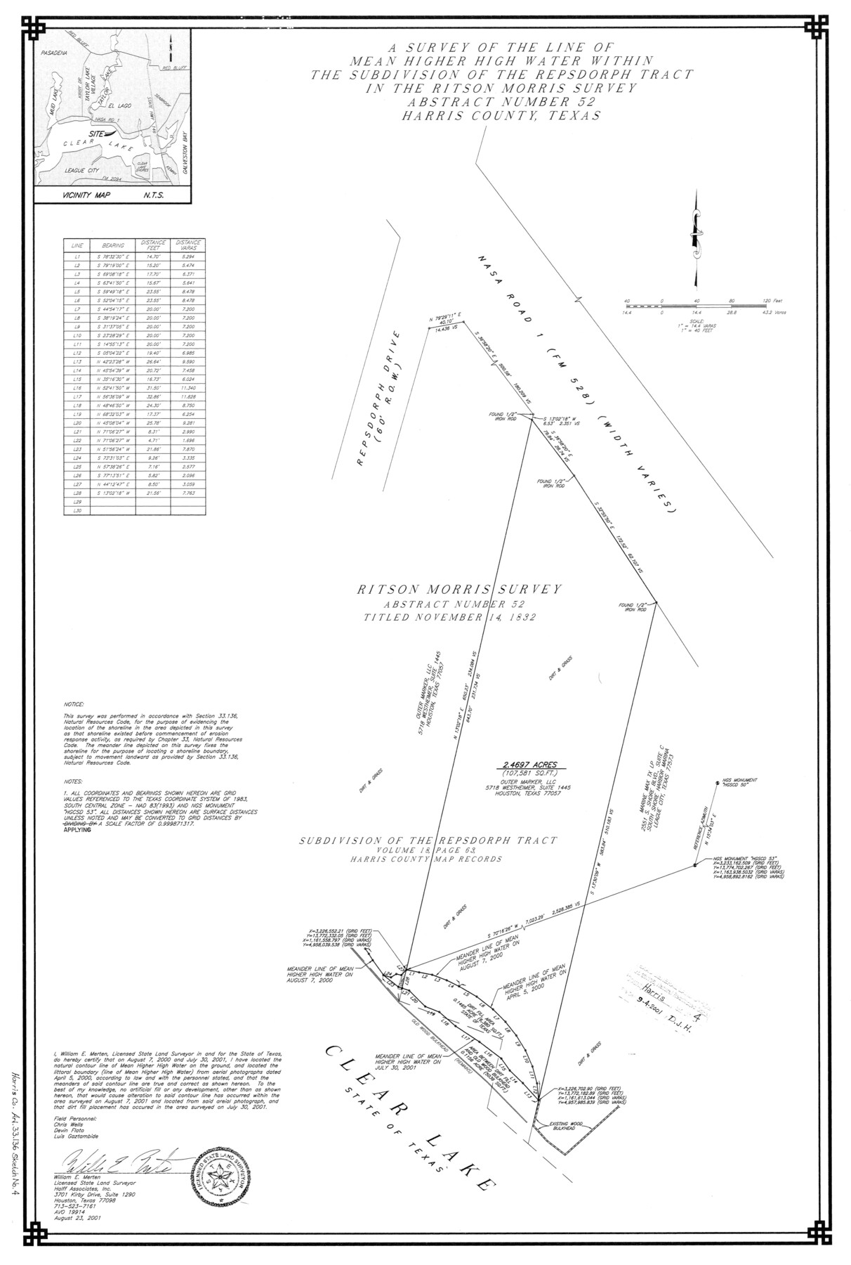
Harris County NRC Article 33.136 Sketch 4
Mean Higher High Water Line Within the Subdivision of the Repsdorph Tract in the Ritson Morris Survey, Abstract 52
Harris County NRC Article 33-136 Report 3
-
Map/Doc
61600
-
Collection
General Map Collection
-
Object Dates
2001/8/23 (Creation Date)
2001/9/4 (File Date)
-
People and Organizations
Halff Associates (Publisher)
Halff Associates (Printer)
William E. Merten (Surveyor/Engineer)
-
Counties
Harris
-
Subjects
Surveying CBS
-
Height x Width
36.1 x 24.3 inches
91.7 x 61.7 cm
-
Medium
multi-page, multi-format
-
Comments
Survey located about 23 3/4 miles South 54 degrees East of Houston, Texas.
Part of: General Map Collection
Jefferson County Working Sketch 26

Print $20.00
- Digital $50.00
Jefferson County Working Sketch 26
1977
Size 39.9 x 36.8 inches
Map/Doc 66569
Fannin County Rolled Sketch 18G

Print $20.00
- Digital $50.00
Fannin County Rolled Sketch 18G
Size 27.9 x 36.0 inches
Map/Doc 5874
A Map of Part of Panola County [Judicial District]
![328, A Map of Part of Panola County [Judicial District], General Map Collection](https://historictexasmaps.com/wmedia_w700/maps/328.tif.jpg)
Print $20.00
- Digital $50.00
A Map of Part of Panola County [Judicial District]
1841
Size 18.3 x 15.4 inches
Map/Doc 328
Right of Way & Track Map San Antonio & Aransas Pass Railway Co.

Print $40.00
- Digital $50.00
Right of Way & Track Map San Antonio & Aransas Pass Railway Co.
1919
Size 25.2 x 56.7 inches
Map/Doc 64040
Flight Mission No. BRA-8M, Frame 75, Jefferson County

Print $20.00
- Digital $50.00
Flight Mission No. BRA-8M, Frame 75, Jefferson County
1953
Size 18.6 x 22.4 inches
Map/Doc 85595
Anderson County Sketch File 26

Print $40.00
- Digital $50.00
Anderson County Sketch File 26
1954
Size 22.7 x 17.4 inches
Map/Doc 10805
Ward County Rolled Sketch 18

Print $20.00
- Digital $50.00
Ward County Rolled Sketch 18
1949
Size 31.6 x 34.0 inches
Map/Doc 10109
Kerr County Boundary File 4

Print $4.00
- Digital $50.00
Kerr County Boundary File 4
Size 11.1 x 8.3 inches
Map/Doc 64799
Fractional Township No. 1N and Township No. 2N R. No. 1E, Deaf Smith and Parmer Counties comprising Capitol Leagues 436, 437, 454, and 455 and parts of Capitol Leagues 433, 434, 435, 438, 453, 456, 457 and 458

Print $20.00
- Digital $50.00
Fractional Township No. 1N and Township No. 2N R. No. 1E, Deaf Smith and Parmer Counties comprising Capitol Leagues 436, 437, 454, and 455 and parts of Capitol Leagues 433, 434, 435, 438, 453, 456, 457 and 458
1906
Size 27.1 x 22.4 inches
Map/Doc 93965
Knox County Sketch File 21

Print $16.00
- Digital $50.00
Knox County Sketch File 21
1917
Size 3.7 x 8.6 inches
Map/Doc 29243
Galveston County Rolled Sketch 27A

Print $20.00
- Digital $50.00
Galveston County Rolled Sketch 27A
1978
Size 32.2 x 35.5 inches
Map/Doc 5962
Kenedy County Rolled Sketch 4A

Print $40.00
- Digital $50.00
Kenedy County Rolled Sketch 4A
1904
Size 40.0 x 56.5 inches
Map/Doc 9332
You may also like
Van Zandt County Sketch File 47a

Print $7.00
- Digital $50.00
Van Zandt County Sketch File 47a
1875
Size 10.0 x 8.2 inches
Map/Doc 39507

Hopkins County Sketch File 16a

Print $4.00
- Digital $50.00
Hopkins County Sketch File 16a
Size 12.1 x 7.6 inches
Map/Doc 26715
Potter County Sketch

Print $20.00
- Digital $50.00
Potter County Sketch
Size 16.3 x 20.9 inches
Map/Doc 91808
Brazos River Conservation and Reclamation District Official Boundary Line Survey

Print $20.00
- Digital $50.00
Brazos River Conservation and Reclamation District Official Boundary Line Survey
Size 25.0 x 37.0 inches
Map/Doc 90182
Photostat of section of hydrographic surveys H-5399, H-4822, H-470

Print $2.00
- Digital $50.00
Photostat of section of hydrographic surveys H-5399, H-4822, H-470
1933
Size 10.8 x 8.1 inches
Map/Doc 61157
San Saba County Boundary File 77

Print $32.00
- Digital $50.00
San Saba County Boundary File 77
Size 9.2 x 7.7 inches
Map/Doc 58577
Tom Green County Rolled Sketch 2

Print $20.00
- Digital $50.00
Tom Green County Rolled Sketch 2
Size 17.2 x 26.8 inches
Map/Doc 7992
Dimmit County Working Sketch 44

Print $20.00
- Digital $50.00
Dimmit County Working Sketch 44
1979
Size 31.7 x 34.0 inches
Map/Doc 68705
Kendall County Working Sketch 7

Print $20.00
- Digital $50.00
Kendall County Working Sketch 7
1950
Size 30.8 x 32.4 inches
Map/Doc 66679
Cottle County Boundary File 1

Print $22.00
- Digital $50.00
Cottle County Boundary File 1
Size 8.8 x 3.8 inches
Map/Doc 51944
Roberts County Working Sketch 36

Print $20.00
- Digital $50.00
Roberts County Working Sketch 36
1978
Size 26.6 x 22.3 inches
Map/Doc 63562