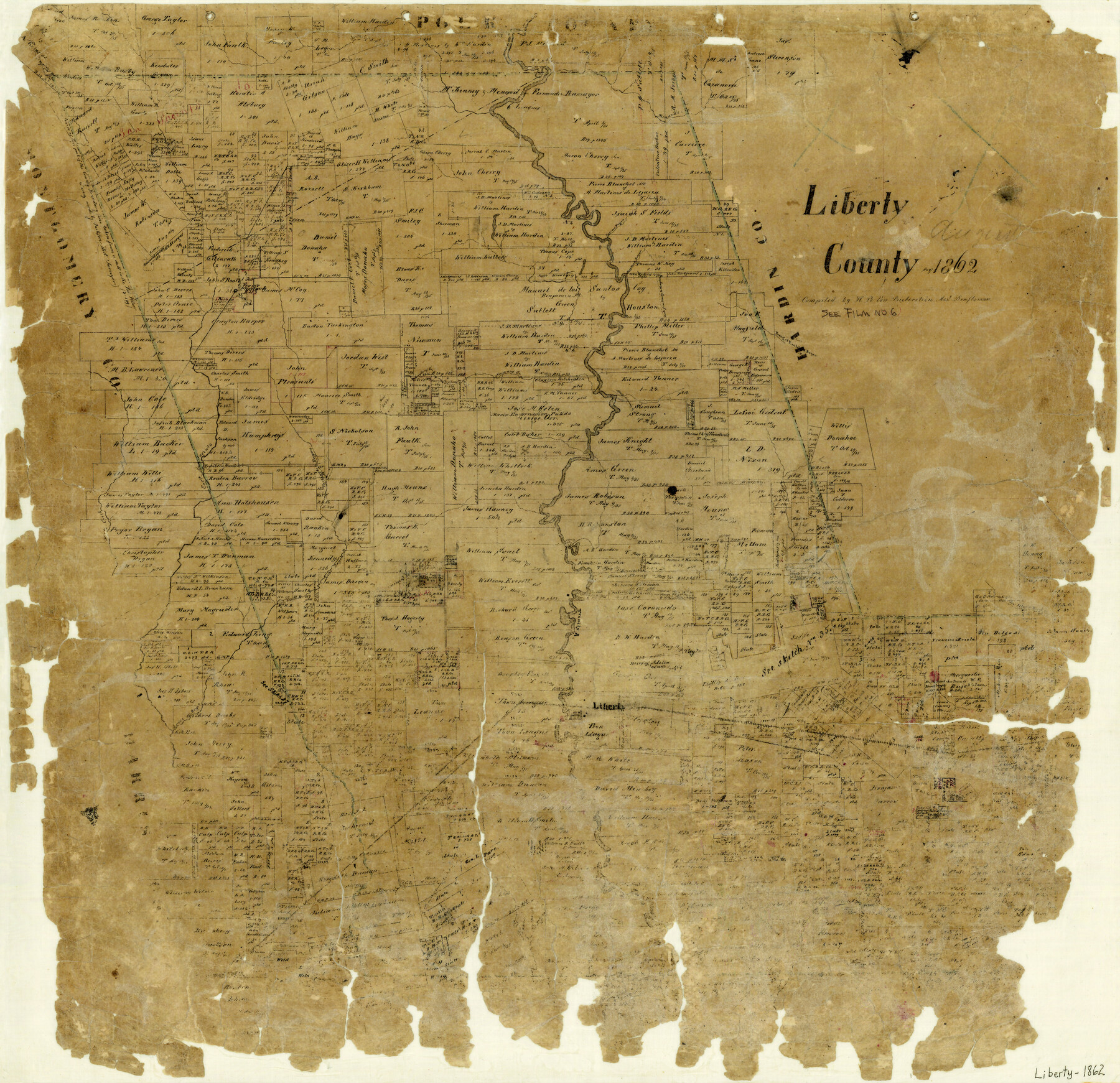
Liberty County
-
Map/Doc
3815
-
Collection
General Map Collection
-
Object Dates
8/1862 (Creation Date)
-
People and Organizations
H.B. von Bieberstein (Compiler)
-
Counties
Liberty
-
Subjects
County
-
Height x Width
24.3 x 24.8 inches
61.7 x 63.0 cm
-
Features
East San Jacinto River
Head of Tarkington Bayou
Liberty
Trinity River
Birch Creek
Luces Bayou
Head of Turtle Bayou
Batiste Creek
Tarkington Bayou
Menard's Creek
Cleveland
Baylors Creek
Newman's Creek
[Road] to Tanners Bluff
Prong of Pine Island Bayou
Route from Liberty to Nacogdoches
Deer Head Bayou
Cypress Bayou
Part of: General Map Collection
Red River County Working Sketch 52

Print $20.00
- Digital $50.00
Red River County Working Sketch 52
1971
Size 35.5 x 24.7 inches
Map/Doc 72035
Wise County Sketch File 2a

Print $4.00
- Digital $50.00
Wise County Sketch File 2a
1856
Size 12.3 x 8.1 inches
Map/Doc 40526
Travis County Rolled Sketch 37

Print $20.00
- Digital $50.00
Travis County Rolled Sketch 37
1942
Size 33.6 x 32.7 inches
Map/Doc 10737
Lubbock County Sketch File 4 and A

Print $40.00
- Digital $50.00
Lubbock County Sketch File 4 and A
Size 22.7 x 29.8 inches
Map/Doc 12016
Flight Mission No. DIX-5P, Frame 115, Aransas County

Print $20.00
- Digital $50.00
Flight Mission No. DIX-5P, Frame 115, Aransas County
1956
Size 17.5 x 17.6 inches
Map/Doc 83794
Bexar County Sketch File 29

Print $40.00
- Digital $50.00
Bexar County Sketch File 29
Size 11.3 x 36.7 inches
Map/Doc 10919
Map of Hall County

Print $20.00
- Digital $50.00
Map of Hall County
1900
Size 41.2 x 41.3 inches
Map/Doc 16842
Flight Mission No. CLL-1N, Frame 36, Willacy County

Print $20.00
- Digital $50.00
Flight Mission No. CLL-1N, Frame 36, Willacy County
1954
Size 18.3 x 22.1 inches
Map/Doc 87017
Bailey County Sketch File 5

Print $40.00
- Digital $50.00
Bailey County Sketch File 5
1907
Size 31.9 x 22.8 inches
Map/Doc 10883
Nolan County Working Sketch 5

Print $3.00
- Digital $50.00
Nolan County Working Sketch 5
1950
Size 9.7 x 13.9 inches
Map/Doc 71296
Amerique Septentrionale

Print $20.00
- Digital $50.00
Amerique Septentrionale
1650
Size 17.2 x 23.1 inches
Map/Doc 93684
Andrews County Working Sketch 14

Print $40.00
- Digital $50.00
Andrews County Working Sketch 14
1957
Size 61.6 x 37.1 inches
Map/Doc 67060
You may also like
Bandera County Sketch File 28

Print $40.00
- Digital $50.00
Bandera County Sketch File 28
Size 23.5 x 20.0 inches
Map/Doc 10897
The Chief Justice County of Liberty. Lands in Conflict with Harrisburg County

Print $20.00
The Chief Justice County of Liberty. Lands in Conflict with Harrisburg County
2020
Size 20.5 x 21.7 inches
Map/Doc 96056
[Surveys along Bray's Bayou]
![157, [Surveys along Bray's Bayou], General Map Collection](https://historictexasmaps.com/wmedia_w700/maps/157.tif.jpg)
Print $2.00
- Digital $50.00
[Surveys along Bray's Bayou]
Size 7.6 x 4.9 inches
Map/Doc 157
Pecos County Sketch File 73

Print $48.00
- Digital $50.00
Pecos County Sketch File 73
1940
Size 8.9 x 9.1 inches
Map/Doc 33876
[Blks. B9, J, D19, John Walker]
![90480, [Blks. B9, J, D19, John Walker], Twichell Survey Records](https://historictexasmaps.com/wmedia_w700/maps/90480-1.tif.jpg)
Print $20.00
- Digital $50.00
[Blks. B9, J, D19, John Walker]
Size 28.6 x 15.9 inches
Map/Doc 90480
Working Sketch from Fisher County [around Roby]
![90911, Working Sketch from Fisher County [around Roby], Twichell Survey Records](https://historictexasmaps.com/wmedia_w700/maps/90911-1.tif.jpg)
Print $20.00
- Digital $50.00
Working Sketch from Fisher County [around Roby]
1901
Size 22.7 x 31.1 inches
Map/Doc 90911
Brewster County Rolled Sketch 114

Print $20.00
- Digital $50.00
Brewster County Rolled Sketch 114
1964
Size 11.6 x 17.3 inches
Map/Doc 5273
Map of the city of Fort Worth and vicinity

Print $20.00
Map of the city of Fort Worth and vicinity
Size 38.6 x 25.9 inches
Map/Doc 93557
Nolan County Rolled Sketch 3

Print $20.00
- Digital $50.00
Nolan County Rolled Sketch 3
Size 27.9 x 26.2 inches
Map/Doc 6864
Flight Mission No. BRA-6M, Frame 92, Jefferson County

Print $20.00
- Digital $50.00
Flight Mission No. BRA-6M, Frame 92, Jefferson County
1953
Size 18.5 x 22.3 inches
Map/Doc 85435
Titus County Sketch File 7

Print $4.00
- Digital $50.00
Titus County Sketch File 7
1853
Size 10.0 x 8.2 inches
Map/Doc 38142
Haskell County Sketch File 8

Print $20.00
- Digital $50.00
Haskell County Sketch File 8
Size 28.3 x 24.7 inches
Map/Doc 11740