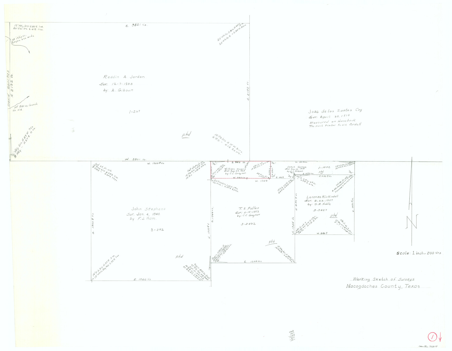
Nacogdoches County Working Sketch 1
-
Map/Doc
71217
-
Collection
General Map Collection
-
Counties
Nacogdoches
-
Subjects
Surveying Working Sketch
-
Height x Width
27.8 x 35.8 inches
70.6 x 90.9 cm
-
Scale
1" = 200 varas
Part of: General Map Collection
Dallas County Boundary File 6g

Print $6.00
- Digital $50.00
Dallas County Boundary File 6g
Size 11.2 x 8.7 inches
Map/Doc 52275
Van Zandt County Rolled Sketch 6

Print $6.00
- Digital $50.00
Van Zandt County Rolled Sketch 6
1946
Size 33.5 x 34.2 inches
Map/Doc 10091
Grayson County Working Sketch 6

Print $20.00
- Digital $50.00
Grayson County Working Sketch 6
1940
Size 28.6 x 40.5 inches
Map/Doc 63245
Baylor County Sketch File 17

Print $4.00
- Digital $50.00
Baylor County Sketch File 17
1872
Size 12.8 x 8.5 inches
Map/Doc 14189
Duval County Boundary File 3l

Print $40.00
- Digital $50.00
Duval County Boundary File 3l
Size 13.4 x 17.1 inches
Map/Doc 52761
Maverick County Rolled Sketch 16

Print $20.00
- Digital $50.00
Maverick County Rolled Sketch 16
1887
Size 21.5 x 31.9 inches
Map/Doc 6709
Map of Carson County

Print $20.00
- Digital $50.00
Map of Carson County
1898
Size 41.2 x 33.8 inches
Map/Doc 4750
Outer Continental Shelf Leasing Maps (Louisiana Offshore Operations)

Print $20.00
- Digital $50.00
Outer Continental Shelf Leasing Maps (Louisiana Offshore Operations)
1955
Size 20.2 x 15.1 inches
Map/Doc 75858
Flight Mission No. DCL-6C, Frame 98, Kenedy County

Print $20.00
- Digital $50.00
Flight Mission No. DCL-6C, Frame 98, Kenedy County
1943
Size 18.6 x 22.3 inches
Map/Doc 85928
Val Verde County Sketch File 48

Print $20.00
- Digital $50.00
Val Verde County Sketch File 48
1950
Size 18.2 x 28.9 inches
Map/Doc 12589
Map of Motley County

Print $20.00
- Digital $50.00
Map of Motley County
1902
Size 43.4 x 37.7 inches
Map/Doc 10799
Reeves County Working Sketch 60

Print $20.00
- Digital $50.00
Reeves County Working Sketch 60
1981
Size 24.7 x 36.3 inches
Map/Doc 63503
You may also like
[Plat Showing San Gabriel & 24th Street Intersection, Outlot 4, Travis County, Texas]
![75795, [Plat Showing San Gabriel & 24th Street Intersection, Outlot 4, Travis County, Texas], Maddox Collection](https://historictexasmaps.com/wmedia_w700/maps/75795.tif.jpg)
Print $2.00
- Digital $50.00
[Plat Showing San Gabriel & 24th Street Intersection, Outlot 4, Travis County, Texas]
Size 11.4 x 8.7 inches
Map/Doc 75795
Hale County Working Sketch 4

Print $20.00
- Digital $50.00
Hale County Working Sketch 4
1979
Size 22.7 x 18.7 inches
Map/Doc 63324
General Highway Map, El Paso County, Texas

Print $20.00
General Highway Map, El Paso County, Texas
1961
Size 18.2 x 24.6 inches
Map/Doc 79459
Midland County Working Sketch 15

Print $20.00
- Digital $50.00
Midland County Working Sketch 15
1953
Size 27.2 x 28.6 inches
Map/Doc 70995
Flight Mission No. BRA-7M, Frame 149, Jefferson County

Print $20.00
- Digital $50.00
Flight Mission No. BRA-7M, Frame 149, Jefferson County
1953
Size 18.7 x 22.5 inches
Map/Doc 85543
Flight Mission No. CUG-3P, Frame 80, Kleberg County

Print $20.00
- Digital $50.00
Flight Mission No. CUG-3P, Frame 80, Kleberg County
1956
Size 18.7 x 22.4 inches
Map/Doc 86255
Hood County Working Sketch 25

Print $20.00
- Digital $50.00
Hood County Working Sketch 25
1995
Size 25.8 x 37.7 inches
Map/Doc 66219
Clay County Sketch File 19

Print $5.00
- Digital $50.00
Clay County Sketch File 19
Size 9.2 x 9.9 inches
Map/Doc 18429
Flight Mission No. CGI-3N, Frame 66, Cameron County

Print $20.00
- Digital $50.00
Flight Mission No. CGI-3N, Frame 66, Cameron County
1954
Size 18.6 x 22.1 inches
Map/Doc 84560
Floyd County Boundary File 4a

Print $40.00
- Digital $50.00
Floyd County Boundary File 4a
Size 12.2 x 35.8 inches
Map/Doc 53496
The Judicial District/County of Panola. Abolished, Spring 1842

Print $20.00
The Judicial District/County of Panola. Abolished, Spring 1842
2020
Size 19.3 x 21.7 inches
Map/Doc 96342
McMullen County Working Sketch 55

Print $20.00
- Digital $50.00
McMullen County Working Sketch 55
1983
Size 15.2 x 19.2 inches
Map/Doc 70756