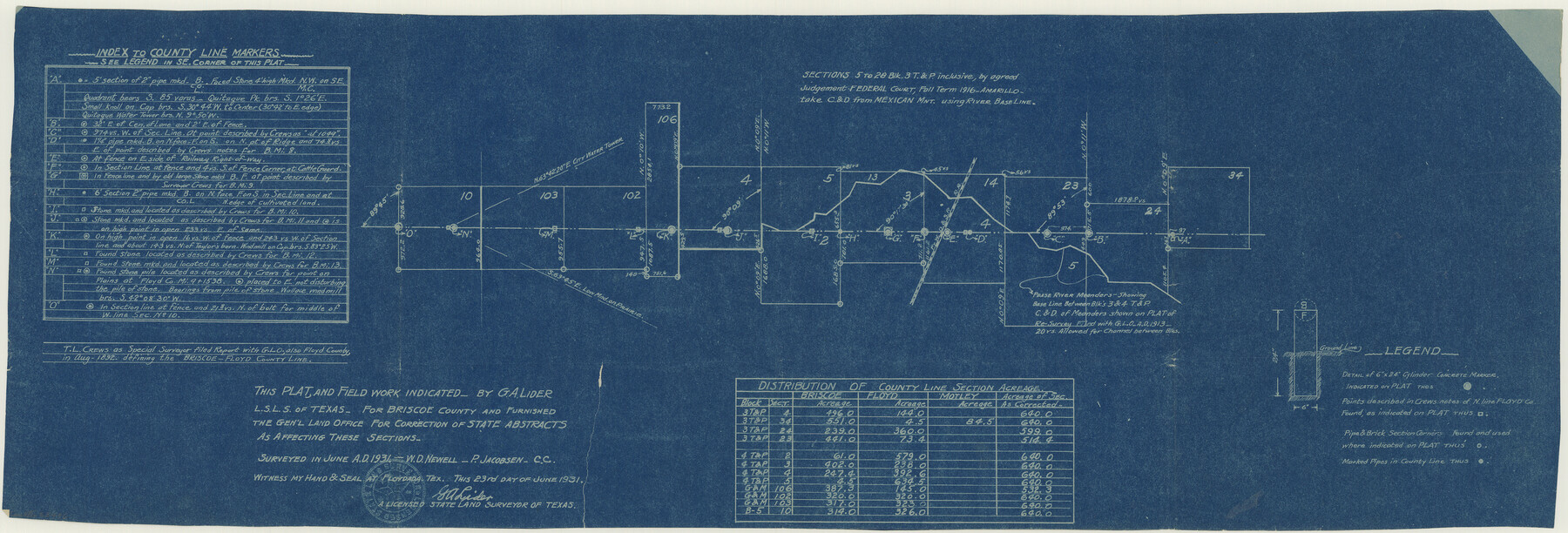
Floyd County Boundary File 4a
Plat of a part of the county line between Briscoe and Floyd Counties
-
Map/Doc
53496
-
Collection
General Map Collection
-
Counties
Floyd
-
Subjects
County Boundaries
-
Height x Width
12.2 x 35.8 inches
31.0 x 90.9 cm
Part of: General Map Collection
Winkler County

Print $20.00
- Digital $50.00
Winkler County
1890
Size 22.8 x 18.5 inches
Map/Doc 4160
Tom Green County

Print $40.00
- Digital $50.00
Tom Green County
1942
Size 55.3 x 46.8 inches
Map/Doc 73304
Duval County Working Sketch 15

Print $20.00
- Digital $50.00
Duval County Working Sketch 15
1938
Size 23.3 x 22.7 inches
Map/Doc 68728
Pecos County Working Sketch 91a

Print $40.00
- Digital $50.00
Pecos County Working Sketch 91a
1965
Size 78.9 x 32.5 inches
Map/Doc 71563
Brown County Working Sketch 7

Print $20.00
- Digital $50.00
Brown County Working Sketch 7
1954
Size 26.5 x 28.7 inches
Map/Doc 67772
Duval County Boundary File 3d

Print $8.00
- Digital $50.00
Duval County Boundary File 3d
Size 14.2 x 8.8 inches
Map/Doc 52738
Right of Way and Track Map International & Gt Northern Ry. operated by the International & Gt. Northern Ry. Co., San Antonio Division

Print $40.00
- Digital $50.00
Right of Way and Track Map International & Gt Northern Ry. operated by the International & Gt. Northern Ry. Co., San Antonio Division
1917
Size 25.7 x 63.1 inches
Map/Doc 64586
Ward County Working Sketch 42

Print $20.00
- Digital $50.00
Ward County Working Sketch 42
1970
Size 42.2 x 41.3 inches
Map/Doc 72348
Comanche County

Print $20.00
- Digital $50.00
Comanche County
1896
Size 40.5 x 45.1 inches
Map/Doc 66783
Rio Grande Rectification Project, El Paso and Juarez Valley

Print $20.00
- Digital $50.00
Rio Grande Rectification Project, El Paso and Juarez Valley
1935
Size 10.7 x 29.4 inches
Map/Doc 60867
Right of Way and Track Map, Galveston, Harrisburg & San Antonio Ry. operated by the T. & N. O. R.R. Co., Victoria Division, Rosenberg to Beeville

Print $40.00
- Digital $50.00
Right of Way and Track Map, Galveston, Harrisburg & San Antonio Ry. operated by the T. & N. O. R.R. Co., Victoria Division, Rosenberg to Beeville
1918
Size 24.4 x 57.9 inches
Map/Doc 76158
Henderson County Working Sketch 4

Print $20.00
- Digital $50.00
Henderson County Working Sketch 4
1918
Size 21.2 x 16.0 inches
Map/Doc 66137
You may also like
Austin, Texas - Congress Ave. Drainage

Print $20.00
- Digital $50.00
Austin, Texas - Congress Ave. Drainage
1905
Size 15.8 x 31.2 inches
Map/Doc 458
Texas Gulf Coast, from the Sabine River to the Rio Grande as Subdivided for Mineral Development; Galveston, Brazoria and Matagorda Counties

Print $40.00
- Digital $50.00
Texas Gulf Coast, from the Sabine River to the Rio Grande as Subdivided for Mineral Development; Galveston, Brazoria and Matagorda Counties
1976
Size 43.8 x 69.3 inches
Map/Doc 1938
Liberty County Working Sketch 48

Print $20.00
- Digital $50.00
Liberty County Working Sketch 48
1954
Size 17.7 x 18.9 inches
Map/Doc 70507
Anderson County Sketch File 22

Print $40.00
- Digital $50.00
Anderson County Sketch File 22
1925
Size 38.0 x 37.5 inches
Map/Doc 10315
Wood County Sketch File 5

Print $4.00
- Digital $50.00
Wood County Sketch File 5
1848
Size 10.7 x 9.0 inches
Map/Doc 40637
Van Zandt County Working Sketch 9

Print $20.00
- Digital $50.00
Van Zandt County Working Sketch 9
1982
Size 12.6 x 11.7 inches
Map/Doc 72259
San Saba County Sketch File 16

Print $20.00
- Digital $50.00
San Saba County Sketch File 16
1902
Size 16.9 x 18.8 inches
Map/Doc 12294
Working Sketch in Lipscomb County

Print $20.00
- Digital $50.00
Working Sketch in Lipscomb County
1910
Size 6.8 x 39.1 inches
Map/Doc 90732
Map showing lines of march and border patrols, in my Mexican Border Service, 1916-1917

Print $20.00
- Digital $50.00
Map showing lines of march and border patrols, in my Mexican Border Service, 1916-1917
1916
Size 18.7 x 41.7 inches
Map/Doc 95822
Plat of Surveys in Hidalgo Co.

Print $20.00
- Digital $50.00
Plat of Surveys in Hidalgo Co.
Size 18.2 x 9.3 inches
Map/Doc 405
Shelby County Working Sketch 23a

Print $20.00
- Digital $50.00
Shelby County Working Sketch 23a
1983
Size 28.1 x 31.0 inches
Map/Doc 63876
Duval County Working Sketch 57

Print $20.00
- Digital $50.00
Duval County Working Sketch 57
1990
Size 30.3 x 25.4 inches
Map/Doc 68781