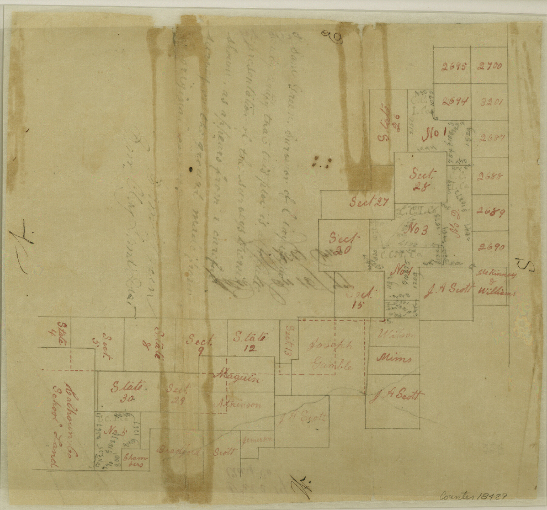
Clay County Sketch File 19
[Sketch of area in the southwest part of the county]
-
Map/Doc
18429
-
Collection
General Map Collection
-
Object Dates
1877/1/15 (File Date)
-
People and Organizations
Sam Green (Surveyor/Engineer)
-
Counties
Clay
-
Subjects
Surveying Sketch File
-
Height x Width
9.2 x 9.9 inches
23.4 x 25.1 cm
-
Medium
paper, manuscript
Part of: General Map Collection
Hamilton County Rolled Sketch 12

Print $20.00
- Digital $50.00
Hamilton County Rolled Sketch 12
1981
Size 35.2 x 28.7 inches
Map/Doc 6061
Flight Mission No. DQN-3K, Frame 7, Calhoun County

Print $20.00
- Digital $50.00
Flight Mission No. DQN-3K, Frame 7, Calhoun County
1953
Size 18.6 x 22.2 inches
Map/Doc 84339
Fractional Township No. 10 South Range No. 9 East of the Indian Meridian, Indian Territory

Print $20.00
- Digital $50.00
Fractional Township No. 10 South Range No. 9 East of the Indian Meridian, Indian Territory
1898
Size 19.3 x 24.4 inches
Map/Doc 75217

Fort Bend County Working Sketch 28

Print $20.00
- Digital $50.00
Fort Bend County Working Sketch 28
1982
Size 15.8 x 20.1 inches
Map/Doc 69234
Flight Mission No. CUG-3P, Frame 24, Kleberg County

Print $20.00
- Digital $50.00
Flight Mission No. CUG-3P, Frame 24, Kleberg County
1956
Size 18.4 x 22.3 inches
Map/Doc 86234
United States - Gulf Coast - From Latitude 26° 33' to the Rio Grande Texas

Print $20.00
- Digital $50.00
United States - Gulf Coast - From Latitude 26° 33' to the Rio Grande Texas
1918
Size 18.4 x 24.3 inches
Map/Doc 72846
Galveston County NRC Article 33.136 Sketch 22

Print $24.00
- Digital $50.00
Galveston County NRC Article 33.136 Sketch 22
2003
Size 24.2 x 36.0 inches
Map/Doc 78661
Presidio County Sketch File P2

Print $6.00
- Digital $50.00
Presidio County Sketch File P2
Size 14.3 x 8.9 inches
Map/Doc 34558
Matagorda County Rolled Sketch 30

Print $20.00
- Digital $50.00
Matagorda County Rolled Sketch 30
1937
Size 24.9 x 35.0 inches
Map/Doc 6693
Dawson County Working Sketch 21

Print $20.00
- Digital $50.00
Dawson County Working Sketch 21
1963
Size 24.0 x 24.0 inches
Map/Doc 68565
Howard County Working Sketch 11

Print $20.00
- Digital $50.00
Howard County Working Sketch 11
1962
Size 20.5 x 20.3 inches
Map/Doc 66279
You may also like
General Highway Map, Houston County, Texas

Print $20.00
General Highway Map, Houston County, Texas
1940
Size 18.3 x 24.8 inches
Map/Doc 79133
Burleson County Working Sketch 10

Print $3.00
- Digital $50.00
Burleson County Working Sketch 10
1980
Size 15.1 x 9.7 inches
Map/Doc 67729
Map of Bosque County

Print $20.00
- Digital $50.00
Map of Bosque County
1869
Size 24.1 x 23.7 inches
Map/Doc 3313
Lamar County Sketch File 3

Print $6.00
- Digital $50.00
Lamar County Sketch File 3
1864
Size 14.2 x 8.6 inches
Map/Doc 29275
Tom Green County Rolled Sketch 8

Print $20.00
- Digital $50.00
Tom Green County Rolled Sketch 8
Size 18.3 x 26.0 inches
Map/Doc 7996
[Sabine County School Land, Block D-10, A3, and B]
![90749, [Sabine County School Land, Block D-10, A3, and B], Twichell Survey Records](https://historictexasmaps.com/wmedia_w700/maps/90749-1.tif.jpg)
Print $20.00
- Digital $50.00
[Sabine County School Land, Block D-10, A3, and B]
Size 15.7 x 20.8 inches
Map/Doc 90749
[Bastrop County School Land Leagues 313 and 314, Thos. H. Cosby League 315 and El Paso County School Land League 316 and surrounding surveys]
![90819, [Bastrop County School Land Leagues 313 and 314, Thos. H. Cosby League 315 and El Paso County School Land League 316 and surrounding surveys], Twichell Survey Records](https://historictexasmaps.com/wmedia_w700/maps/90819-2.tif.jpg)
Print $3.00
- Digital $50.00
[Bastrop County School Land Leagues 313 and 314, Thos. H. Cosby League 315 and El Paso County School Land League 316 and surrounding surveys]
1898
Size 10.5 x 12.6 inches
Map/Doc 90819
Milam County Boundary File 5

Print $18.00
- Digital $50.00
Milam County Boundary File 5
Size 8.9 x 9.7 inches
Map/Doc 57223
Detail Sketch of A.B. Robertson's Ranch and J.W. James' Ranch situated in Garza and Crosby Counties, Texas

Print $40.00
- Digital $50.00
Detail Sketch of A.B. Robertson's Ranch and J.W. James' Ranch situated in Garza and Crosby Counties, Texas
Size 51.7 x 34.3 inches
Map/Doc 89754
Maps & Lists Showing Prison Lands (Oil & Gas) Leased as of June 1955

Digital $50.00
Maps & Lists Showing Prison Lands (Oil & Gas) Leased as of June 1955
Size 11.4 x 7.3 inches
Map/Doc 62868
Map of South America to illustrate Olney's school geography

Print $20.00
- Digital $50.00
Map of South America to illustrate Olney's school geography
1844
Size 12.1 x 9.5 inches
Map/Doc 93545
Flight Mission No. CRK-8P, Frame 118, Refugio County

Print $20.00
- Digital $50.00
Flight Mission No. CRK-8P, Frame 118, Refugio County
1956
Size 18.3 x 22.1 inches
Map/Doc 86973