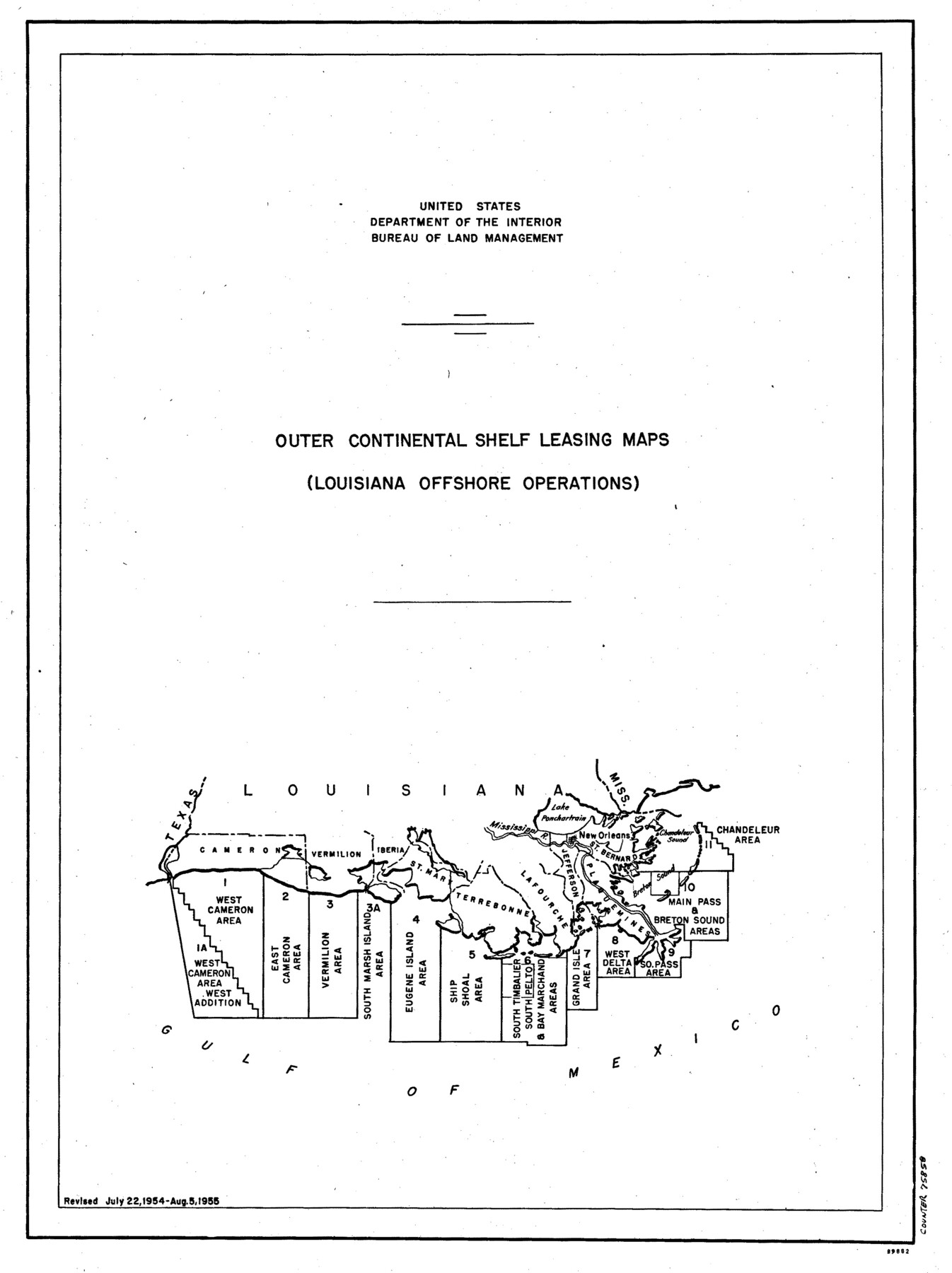
Outer Continental Shelf Leasing Maps (Louisiana Offshore Operations)
D-7-3; D-7-4
-
Map/Doc
75858
-
Collection
General Map Collection
-
Object Dates
1955/8/5 (Creation Date)
-
Subjects
Energy Offshore Submerged Area
-
Height x Width
20.2 x 15.1 inches
51.3 x 38.4 cm
Part of: General Map Collection
Matagorda County Sketch File 5

Print $4.00
- Digital $50.00
Matagorda County Sketch File 5
Size 10.0 x 8.0 inches
Map/Doc 30736
Hardin County Sketch File 48

Print $20.00
- Digital $50.00
Hardin County Sketch File 48
Size 17.8 x 18.4 inches
Map/Doc 11634
Comal County Sketch File 8

Print $6.00
- Digital $50.00
Comal County Sketch File 8
1849
Size 12.6 x 10.8 inches
Map/Doc 19013
Texas, San Antonio Bay, Hynes Bay

Print $40.00
- Digital $50.00
Texas, San Antonio Bay, Hynes Bay
1934
Size 33.0 x 48.9 inches
Map/Doc 69998
Shelby County Working Sketch 15

Print $20.00
- Digital $50.00
Shelby County Working Sketch 15
1952
Size 24.5 x 19.2 inches
Map/Doc 63868
Starr County Sketch File 52

Print $4.00
- Digital $50.00
Starr County Sketch File 52
Size 13.9 x 9.0 inches
Map/Doc 37011
Hockley County Sketch File M

Print $20.00
- Digital $50.00
Hockley County Sketch File M
Size 22.2 x 25.8 inches
Map/Doc 11777
Knox County Working Sketch 4

Print $20.00
- Digital $50.00
Knox County Working Sketch 4
1919
Size 18.0 x 25.6 inches
Map/Doc 70246
Dallas County Working Sketch 19

Print $20.00
- Digital $50.00
Dallas County Working Sketch 19
1997
Size 23.1 x 30.3 inches
Map/Doc 68585
Maps of Gulf Intracoastal Waterway, Texas - Sabine River to the Rio Grande and connecting waterways including ship channels

Print $20.00
- Digital $50.00
Maps of Gulf Intracoastal Waterway, Texas - Sabine River to the Rio Grande and connecting waterways including ship channels
1966
Size 14.6 x 22.5 inches
Map/Doc 61935
S. M. S. Flat Top Ranch

Print $6.00
- Digital $50.00
S. M. S. Flat Top Ranch
1955
Size 23.2 x 32.8 inches
Map/Doc 2102
Van Zandt County

Print $20.00
- Digital $50.00
Van Zandt County
1896
Size 26.1 x 22.4 inches
Map/Doc 4114
You may also like
Dimmit County Sketch File 11

Print $12.00
- Digital $50.00
Dimmit County Sketch File 11
1880
Size 12.9 x 8.2 inches
Map/Doc 21075
[Sketch for Mineral Application 24072, San Jacinto River]
![65608, [Sketch for Mineral Application 24072, San Jacinto River], General Map Collection](https://historictexasmaps.com/wmedia_w700/maps/65608.tif.jpg)
Print $20.00
- Digital $50.00
[Sketch for Mineral Application 24072, San Jacinto River]
1929
Size 8.6 x 14.0 inches
Map/Doc 65608
Leon County Rolled Sketch 19

Print $20.00
- Digital $50.00
Leon County Rolled Sketch 19
1982
Size 23.9 x 37.4 inches
Map/Doc 6605
[Surveys in the Bexar District along the Pedernales River]
![177, [Surveys in the Bexar District along the Pedernales River], General Map Collection](https://historictexasmaps.com/wmedia_w700/maps/177.tif.jpg)
Print $20.00
- Digital $50.00
[Surveys in the Bexar District along the Pedernales River]
1845
Size 18.7 x 11.0 inches
Map/Doc 177
[1/4 of a WWI French map of Attigny used by the 142nd Infantry for planning purposes for the Battle of Forest Ferme (farm)]
![96642, [1/4 of a WWI French map of Attigny used by the 142nd Infantry for planning purposes for the Battle of Forest Ferme (farm)], Non-GLO Digital Images](https://historictexasmaps.com/wmedia_w700/maps/96642.tif.jpg)
Print $20.00
[1/4 of a WWI French map of Attigny used by the 142nd Infantry for planning purposes for the Battle of Forest Ferme (farm)]
1918
Size 21.1 x 17.7 inches
Map/Doc 96642
Brewster County Rolled Sketch 99

Print $20.00
- Digital $50.00
Brewster County Rolled Sketch 99
1953
Size 26.6 x 22.4 inches
Map/Doc 5255
United States - Gulf Coast - Galveston to Rio Grande

Print $20.00
- Digital $50.00
United States - Gulf Coast - Galveston to Rio Grande
1940
Size 27.0 x 18.2 inches
Map/Doc 72755
Clay County Sketch File 17

Print $4.00
- Digital $50.00
Clay County Sketch File 17
1855
Size 6.8 x 8.7 inches
Map/Doc 18425
Van Zandt County

Print $20.00
- Digital $50.00
Van Zandt County
1870
Size 22.8 x 21.1 inches
Map/Doc 4638
Jim Hogg County Working Sketch 10

Print $20.00
- Digital $50.00
Jim Hogg County Working Sketch 10
Size 18.8 x 15.6 inches
Map/Doc 66596
Wilbarger County Working Sketch 10

Print $20.00
- Digital $50.00
Wilbarger County Working Sketch 10
1951
Size 23.5 x 32.3 inches
Map/Doc 72548
Brazoria County Working Sketch 24

Print $20.00
- Digital $50.00
Brazoria County Working Sketch 24
1963
Size 35.7 x 25.0 inches
Map/Doc 67509