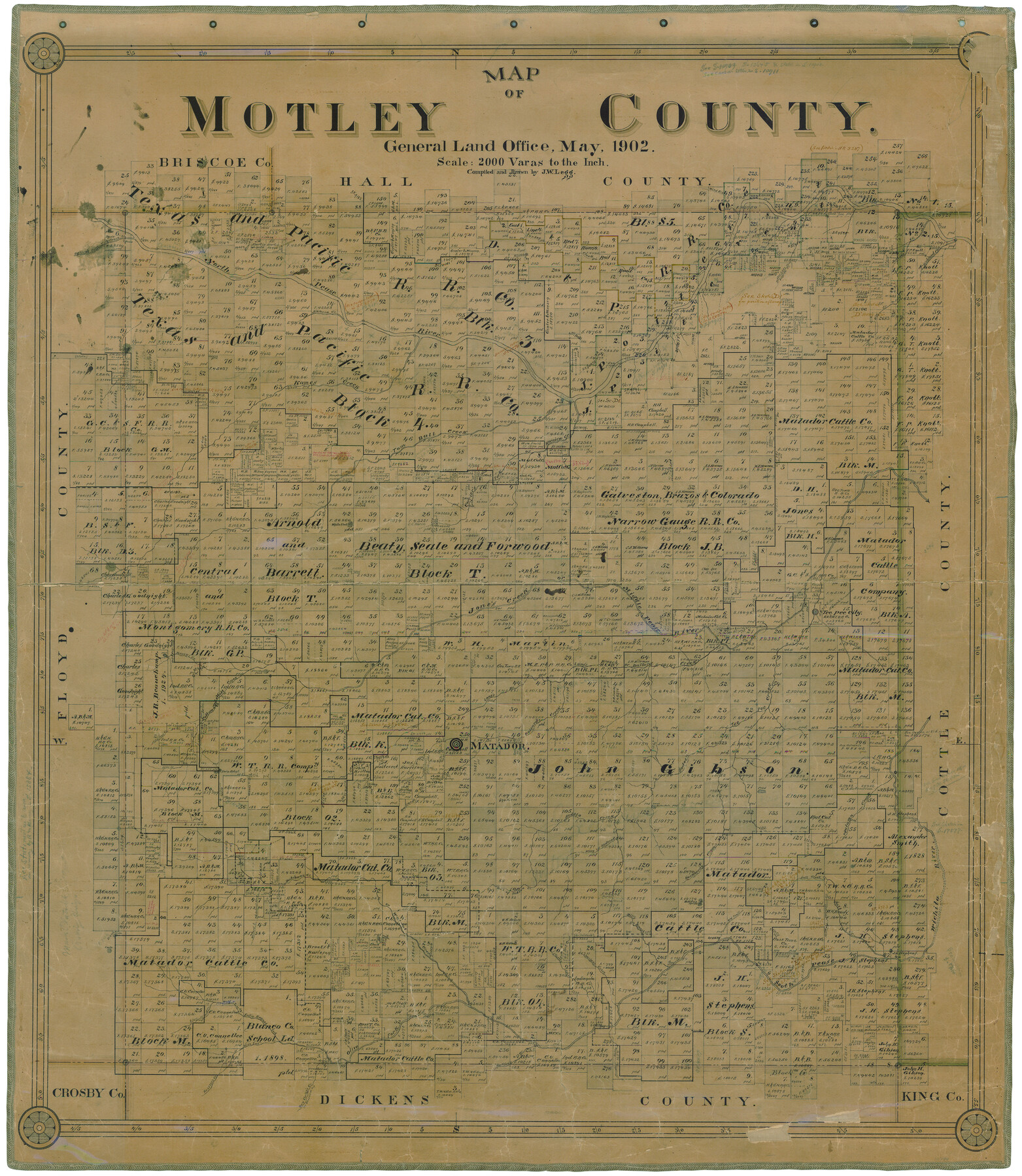
Map of Motley County
-
Map/Doc
10799
-
Collection
General Map Collection
-
Object Dates
5/1902 (Creation Date)
-
People and Organizations
Texas General Land Office (Publisher)
J. Watt Legg (Draftsman)
J. Watt Legg (Compiler)
-
Counties
Motley
-
Subjects
County
-
Height x Width
43.4 x 37.7 inches
110.2 x 95.8 cm
-
Comments
Help Save Texas History - Adopt Me!
-
Features
Warren's Fork of North Pease River
Robert's Creek
Alamosa Creek
Pease River
Dutchman Creek
Tee Pee Creek
Walnut Creek
Ballard Road
Whitehouse Road
Rustler's Creek
Dan Corley's Creek
Grapevine Creek
Sisk Creek
Joe Lake Creek
Bitter Lake Creek
Antelope Creek
Richland Creek
Quetaquae [sic] Creek
Middle Pease River
Connellee's Peak
Matador
Hell's Gap Mountains
Sallie Haynes Fork [of South Pease River]
Wolf Creek
T&P
Long's Creek
Tee Pee City
White Flat [Mountain]
Twin Mountains
Kames Creek
Dutchman Creek
Old Trail
Hornica Creek
Corrier's Fork [of North Pease River]
Long's Branch [of Middle Pease River]
Boggy Creek
John Hall Creek
Jones Creek
Cottonwood Mott Creek
Ballard's Creek
Autumn Creek
Sodosa Creek
Prong of Sodosa Creek
Head of Sodosa Creek
Bill's Branch [of South Pease River]
Hackberry Creek
Tom Ball Creek
Salt Creek
Tarrant's Creek
Wichita River
South Pease River
Darden's Cañon
Elliot's Cañon
Ballard and Whitehouse Road
South Fork of Wolf Creek
Olive Fork [of South Pease River]
Jackson's Branch [of South Pease River]
Saunder's Hollow
North Pease River
Turkey Creek
Wind River
Part of: General Map Collection
Sutton County Sketch File 50

Print $20.00
- Digital $50.00
Sutton County Sketch File 50
1941
Size 18.6 x 18.4 inches
Map/Doc 12392
Red River County

Print $20.00
- Digital $50.00
Red River County
1934
Size 45.0 x 38.6 inches
Map/Doc 77405
Galveston County NRC Article 33.136 Sketch 27

Print $126.00
- Digital $50.00
Galveston County NRC Article 33.136 Sketch 27
2003
Size 24.4 x 36.2 inches
Map/Doc 81970
Stonewall County Rolled Sketch 24B

Print $40.00
- Digital $50.00
Stonewall County Rolled Sketch 24B
1954
Size 50.1 x 43.1 inches
Map/Doc 9964
Flight Mission No. CLL-1N, Frame 107, Willacy County

Print $20.00
- Digital $50.00
Flight Mission No. CLL-1N, Frame 107, Willacy County
1954
Size 18.5 x 22.1 inches
Map/Doc 87041
Lavaca County Working Sketch 18

Print $20.00
- Digital $50.00
Lavaca County Working Sketch 18
1979
Size 37.0 x 20.3 inches
Map/Doc 70371
Hutchinson County Working Sketch 21

Print $20.00
- Digital $50.00
Hutchinson County Working Sketch 21
1965
Size 35.0 x 40.8 inches
Map/Doc 66381
Atascosa County Sketch File 3c

Print $4.00
- Digital $50.00
Atascosa County Sketch File 3c
1858
Size 14.3 x 7.3 inches
Map/Doc 13743
Map of Encinal County

Print $20.00
- Digital $50.00
Map of Encinal County
1872
Size 30.5 x 20.3 inches
Map/Doc 3513
Flight Mission No. BQR-9K, Frame 47, Brazoria County

Print $20.00
- Digital $50.00
Flight Mission No. BQR-9K, Frame 47, Brazoria County
1952
Size 18.7 x 22.4 inches
Map/Doc 84051
Map of Henderson County

Print $40.00
- Digital $50.00
Map of Henderson County
1897
Size 27.7 x 56.8 inches
Map/Doc 16849
Kinney County Working Sketch 17

Print $20.00
- Digital $50.00
Kinney County Working Sketch 17
1947
Size 29.4 x 38.7 inches
Map/Doc 70199
You may also like
Hall County Sketch File 32

Print $14.00
- Digital $50.00
Hall County Sketch File 32
1911
Size 11.2 x 8.8 inches
Map/Doc 24839
[Surveys along the Guadalupe River and Blanco Creek]
![45, [Surveys along the Guadalupe River and Blanco Creek], General Map Collection](https://historictexasmaps.com/wmedia_w700/maps/45.tif.jpg)
Print $20.00
- Digital $50.00
[Surveys along the Guadalupe River and Blanco Creek]
Size 19.5 x 15.7 inches
Map/Doc 45
Hudspeth County Rolled Sketch 74

Print $40.00
- Digital $50.00
Hudspeth County Rolled Sketch 74
1992
Size 49.5 x 38.1 inches
Map/Doc 9237
Stonewall County Sketch File 29

Print $4.00
- Digital $50.00
Stonewall County Sketch File 29
1976
Size 11.3 x 8.5 inches
Map/Doc 37306
Brazoria County NRC Article 33.136 Sketch 24

Print $24.00
Brazoria County NRC Article 33.136 Sketch 24
2025
Map/Doc 97504
Mills County Boundary File 2

Print $6.00
- Digital $50.00
Mills County Boundary File 2
Size 14.1 x 8.7 inches
Map/Doc 57278
Culberson County Working Sketch 16

Print $20.00
- Digital $50.00
Culberson County Working Sketch 16
1926
Size 17.5 x 23.4 inches
Map/Doc 68468
Pecos County Rolled Sketch 103

Print $20.00
- Digital $50.00
Pecos County Rolled Sketch 103
1940
Size 27.5 x 32.4 inches
Map/Doc 7251
Map Showing the Barranco Blanco, Rincon del Oso, and Rincon de Corpus Christi Grants

Print $40.00
- Digital $50.00
Map Showing the Barranco Blanco, Rincon del Oso, and Rincon de Corpus Christi Grants
1886
Size 58.8 x 80.1 inches
Map/Doc 16781
Marion County Working Sketch 29

Print $20.00
- Digital $50.00
Marion County Working Sketch 29
1977
Size 20.4 x 16.1 inches
Map/Doc 70805
[Blocks K3, K4, K7, K8, K14, M7, east part of Leagues]
![90592, [Blocks K3, K4, K7, K8, K14, M7, east part of Leagues], Twichell Survey Records](https://historictexasmaps.com/wmedia_w700/maps/90592-1.tif.jpg)
Print $20.00
- Digital $50.00
[Blocks K3, K4, K7, K8, K14, M7, east part of Leagues]
Size 33.4 x 31.8 inches
Map/Doc 90592
Montgomery County Working Sketch 68

Print $20.00
- Digital $50.00
Montgomery County Working Sketch 68
1972
Size 25.9 x 33.7 inches
Map/Doc 71175