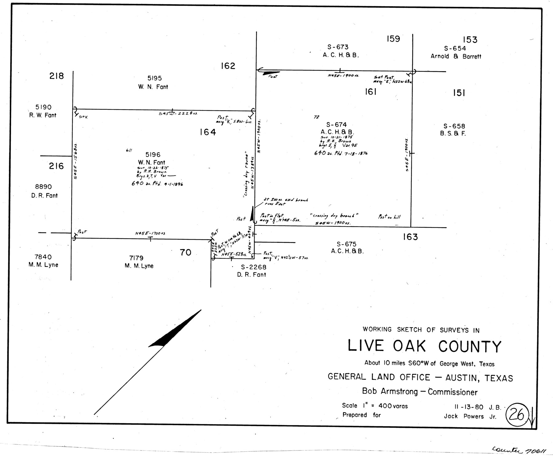
Live Oak County Working Sketch 26
-
Map/Doc
70611
-
Collection
General Map Collection
-
Object Dates
11/13/1980 (Creation Date)
-
People and Organizations
Jana Brod (Draftsman)
-
Counties
Live Oak
-
Subjects
Surveying Working Sketch
-
Height x Width
13.9 x 16.9 inches
35.3 x 42.9 cm
-
Scale
1" = 400 varas
Part of: General Map Collection
Shackelford County Working Sketch 1

Print $20.00
- Digital $50.00
Shackelford County Working Sketch 1
Size 15.1 x 18.4 inches
Map/Doc 63841
Webb County Rolled Sketch 31

Print $20.00
- Digital $50.00
Webb County Rolled Sketch 31
Size 38.8 x 44.5 inches
Map/Doc 10122
Map of Panola County

Print $20.00
- Digital $50.00
Map of Panola County
1871
Size 16.5 x 17.7 inches
Map/Doc 3938
Wichita County Sketch File 19

Print $20.00
- Digital $50.00
Wichita County Sketch File 19
Size 21.9 x 22.5 inches
Map/Doc 12681
Boundary Between the United States & Mexico Agreed upon by the Joint Commission under the Treaty of Guadalupe Hidalgo

Print $4.00
- Digital $50.00
Boundary Between the United States & Mexico Agreed upon by the Joint Commission under the Treaty of Guadalupe Hidalgo
1853
Size 18.2 x 26.8 inches
Map/Doc 72879
Cooke County Sketch File 10

Print $4.00
- Digital $50.00
Cooke County Sketch File 10
1855
Size 13.0 x 8.4 inches
Map/Doc 19242
Brewster County Working Sketch 47

Print $20.00
- Digital $50.00
Brewster County Working Sketch 47
1949
Size 42.9 x 35.4 inches
Map/Doc 67581
Reeves County Working Sketch 30

Print $20.00
- Digital $50.00
Reeves County Working Sketch 30
1969
Size 31.1 x 36.5 inches
Map/Doc 63473
Leon County Rolled Sketch 27A

Print $40.00
- Digital $50.00
Leon County Rolled Sketch 27A
Size 50.5 x 47.8 inches
Map/Doc 9437
Trinity River, Crabtree Ferry Sheet

Print $20.00
- Digital $50.00
Trinity River, Crabtree Ferry Sheet
1922
Size 41.9 x 37.8 inches
Map/Doc 65186
Gregg County Working Sketch 12

Print $20.00
- Digital $50.00
Gregg County Working Sketch 12
1940
Size 11.0 x 18.9 inches
Map/Doc 63279
Baylor County Sketch File 7

Print $4.00
- Digital $50.00
Baylor County Sketch File 7
Size 6.7 x 10.2 inches
Map/Doc 14135
You may also like
Refugio County Sketch File 26

Print $4.00
- Digital $50.00
Refugio County Sketch File 26
Size 12.9 x 8.4 inches
Map/Doc 35292
Leon County Sketch File 32

Print $4.00
- Digital $50.00
Leon County Sketch File 32
1955
Size 14.2 x 8.7 inches
Map/Doc 29832
Schleicher County

Print $40.00
- Digital $50.00
Schleicher County
1940
Size 39.4 x 56.0 inches
Map/Doc 63028
Flight Mission No. BRA-16M, Frame 177, Jefferson County

Print $20.00
- Digital $50.00
Flight Mission No. BRA-16M, Frame 177, Jefferson County
1953
Size 18.7 x 22.3 inches
Map/Doc 85775
Carta Politica

Print $20.00
- Digital $50.00
Carta Politica
1897
Size 26.2 x 34.1 inches
Map/Doc 96797
[Blocks 34-36, Township 1N]
![92032, [Blocks 34-36, Township 1N], Twichell Survey Records](https://historictexasmaps.com/wmedia_w700/maps/92032-1.tif.jpg)
Print $20.00
- Digital $50.00
[Blocks 34-36, Township 1N]
Size 37.0 x 24.0 inches
Map/Doc 92032
[Parts of Public School Land Blocks 39, 31, C-40, C-42, E. L. & R. R. Blocks H, I]
![91271, [Parts of Public School Land Blocks 39, 31, C-40, C-42, E. L. & R. R. Blocks H, I], Twichell Survey Records](https://historictexasmaps.com/wmedia_w700/maps/91271-1.tif.jpg)
Print $20.00
- Digital $50.00
[Parts of Public School Land Blocks 39, 31, C-40, C-42, E. L. & R. R. Blocks H, I]
Size 14.2 x 19.5 inches
Map/Doc 91271
Edwards County Sketch File 14 1/2

Print $20.00
- Digital $50.00
Edwards County Sketch File 14 1/2
1887
Size 18.3 x 15.3 inches
Map/Doc 11426
Jeff Davis County Sketch File 23

Print $4.00
- Digital $50.00
Jeff Davis County Sketch File 23
1927
Size 13.3 x 8.8 inches
Map/Doc 27990
Brazoria County Sketch File 24

Print $6.00
- Digital $50.00
Brazoria County Sketch File 24
1868
Size 11.3 x 10.4 inches
Map/Doc 15022
Angelina County Working Sketch 42

Print $20.00
- Digital $50.00
Angelina County Working Sketch 42
1960
Size 22.4 x 18.2 inches
Map/Doc 67125
Sherman County

Print $20.00
- Digital $50.00
Sherman County
1902
Size 41.0 x 36.7 inches
Map/Doc 63035