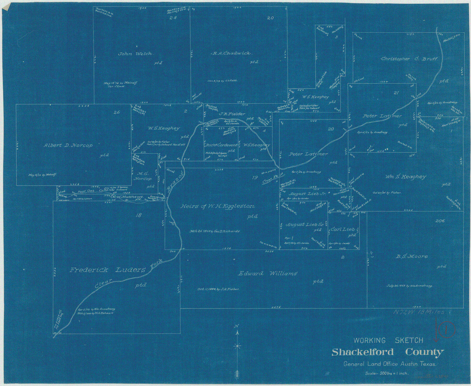
Shackelford County Working Sketch 1
-
Map/Doc
63841
-
Collection
General Map Collection
-
Counties
Shackelford
-
Subjects
Surveying Working Sketch
-
Height x Width
15.1 x 18.4 inches
38.4 x 46.7 cm
-
Scale
1" = 500 varas
Part of: General Map Collection
Liberty County Sketch File 68

Print $24.00
- Digital $50.00
Liberty County Sketch File 68
Size 11.0 x 8.5 inches
Map/Doc 94021
Real County Working Sketch 57

Print $4.00
- Digital $50.00
Real County Working Sketch 57
1962
Size 19.6 x 25.8 inches
Map/Doc 71949

[Military surveys on headwaters of Red River]
![3099, [Military surveys on headwaters of Red River], General Map Collection](https://historictexasmaps.com/wmedia_w700/maps/3099-1.tif.jpg)
Print $20.00
- Digital $50.00
[Military surveys on headwaters of Red River]
1878
Size 31.6 x 39.0 inches
Map/Doc 3099
Navigation Maps of Gulf Intracoastal Waterway, Port Arthur to Brownsville, Texas

Print $4.00
- Digital $50.00
Navigation Maps of Gulf Intracoastal Waterway, Port Arthur to Brownsville, Texas
1951
Size 16.6 x 21.6 inches
Map/Doc 65422
Map of Jefferson County

Print $20.00
- Digital $50.00
Map of Jefferson County
1840
Size 34.8 x 27.0 inches
Map/Doc 3726
Map of Titus County

Print $20.00
- Digital $50.00
Map of Titus County
1857
Size 23.8 x 34.3 inches
Map/Doc 4857
Culberson County Sketch File 22

Print $6.00
- Digital $50.00
Culberson County Sketch File 22
1934
Size 11.8 x 8.8 inches
Map/Doc 20234
Falls County Sketch File 1

Print $4.00
- Digital $50.00
Falls County Sketch File 1
1852
Size 10.7 x 8.6 inches
Map/Doc 22330
Flight Mission No. DQN-2K, Frame 95, Calhoun County

Print $20.00
- Digital $50.00
Flight Mission No. DQN-2K, Frame 95, Calhoun County
1953
Size 18.6 x 22.3 inches
Map/Doc 84285
Brewster County Rolled Sketch 53

Print $20.00
- Digital $50.00
Brewster County Rolled Sketch 53
1934
Size 43.8 x 37.6 inches
Map/Doc 8480
Hardin County

Print $20.00
- Digital $50.00
Hardin County
1940
Size 40.7 x 37.7 inches
Map/Doc 77303
You may also like
[Located Line of the Panhandle & Gulf Ry. through State Lands]
![64103, [Located Line of the Panhandle & Gulf Ry. through State Lands], General Map Collection](https://historictexasmaps.com/wmedia_w700/maps/64103.tif.jpg)
Print $40.00
- Digital $50.00
[Located Line of the Panhandle & Gulf Ry. through State Lands]
1904
Size 12.4 x 121.6 inches
Map/Doc 64103
Subdivision of Tract 2, Soash-White Industrial Addition, Part of Southeast Quarter, Section 2, Block E (Geo. W. Soash - J. B. White, Owners)

Print $20.00
- Digital $50.00
Subdivision of Tract 2, Soash-White Industrial Addition, Part of Southeast Quarter, Section 2, Block E (Geo. W. Soash - J. B. White, Owners)
1956
Size 22.8 x 17.6 inches
Map/Doc 92775
Flight Mission No. BQY-4M, Frame 119, Harris County

Print $20.00
- Digital $50.00
Flight Mission No. BQY-4M, Frame 119, Harris County
1953
Size 18.7 x 22.4 inches
Map/Doc 85287
Hays County Rolled Sketch 28

Print $20.00
- Digital $50.00
Hays County Rolled Sketch 28
1954
Size 20.2 x 37.5 inches
Map/Doc 6183
The Scarborough Company's New Railroad, Post Office & County Map of Texas, Oklahoma and Indian Territory Compiled from the Latest Government Surveys and Original Sources

Print $20.00
The Scarborough Company's New Railroad, Post Office & County Map of Texas, Oklahoma and Indian Territory Compiled from the Latest Government Surveys and Original Sources
1904
Size 43.1 x 47.8 inches
Map/Doc 93967
Kendall County Sketch File 17

Print $4.00
- Digital $50.00
Kendall County Sketch File 17
1878
Size 9.1 x 7.6 inches
Map/Doc 28709
Mills County Working Sketch 24

Print $20.00
- Digital $50.00
Mills County Working Sketch 24
1988
Size 40.3 x 36.5 inches
Map/Doc 71054
[Texas Boundary Line]
![92077, [Texas Boundary Line], Twichell Survey Records](https://historictexasmaps.com/wmedia_w700/maps/92077-1.tif.jpg)
Print $20.00
- Digital $50.00
[Texas Boundary Line]
Size 21.2 x 12.0 inches
Map/Doc 92077
San Saba County Sketch File 7a

Print $6.00
- Digital $50.00
San Saba County Sketch File 7a
1883
Size 16.4 x 10.5 inches
Map/Doc 36428
Parker County Sketch File 40

Print $4.00
- Digital $50.00
Parker County Sketch File 40
Size 8.1 x 12.7 inches
Map/Doc 33585
Flight Mission No. DAH-17M, Frame 28, Orange County

Print $20.00
- Digital $50.00
Flight Mission No. DAH-17M, Frame 28, Orange County
1953
Size 18.5 x 22.3 inches
Map/Doc 86891
El Paso County Rolled Sketch 43B

Print $20.00
- Digital $50.00
El Paso County Rolled Sketch 43B
Size 22.0 x 22.0 inches
Map/Doc 5830